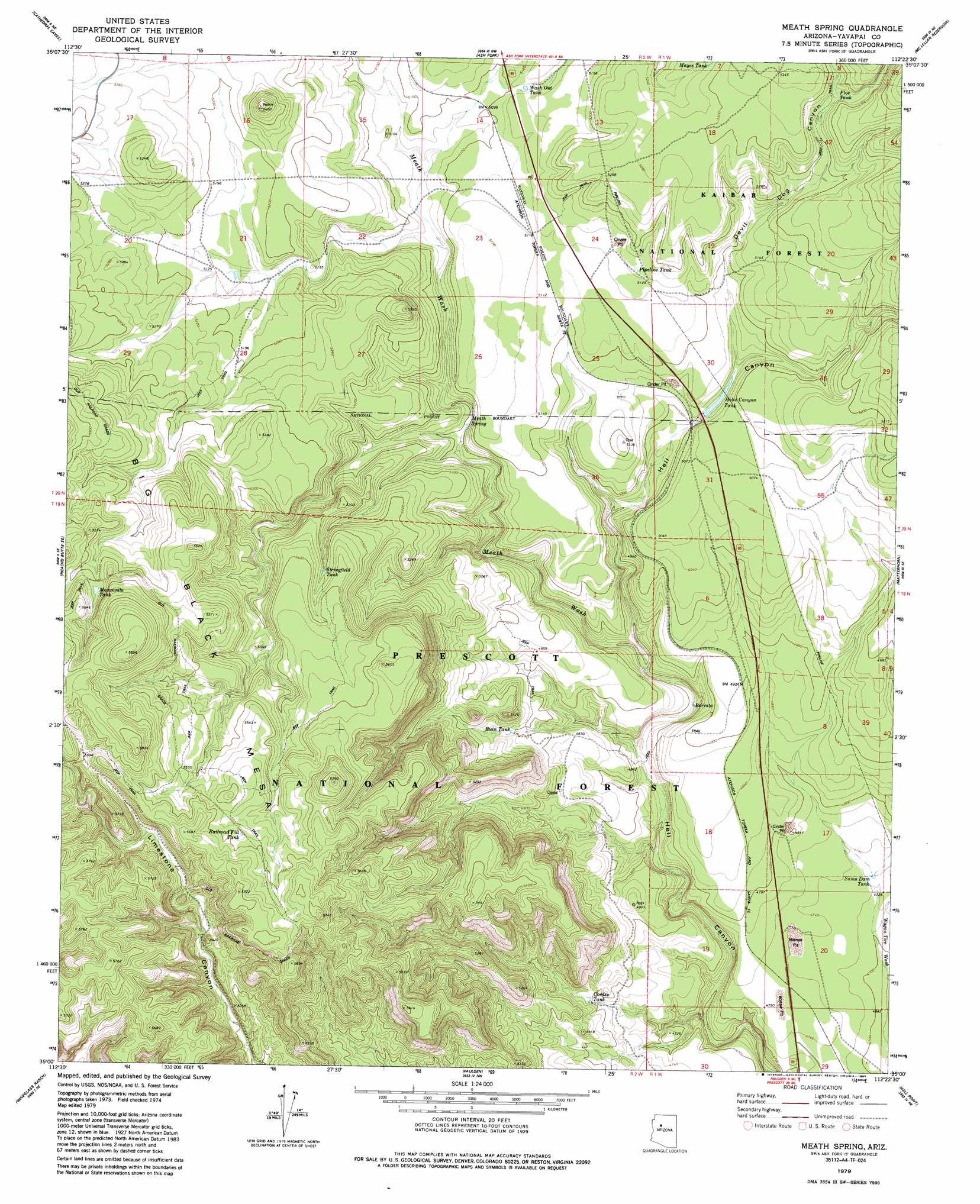
Meath Spring Topo Map Arizona
To zoom in, hover over the map of Meath Spring
USGS Topo Quad 35112a4 - 1:24,000 scale
| Topo Map Name: | Meath Spring |
| USGS Topo Quad ID: | 35112a4 |
| Print Size: | ca. 21 1/4" wide x 27" high |
| Southeast Coordinates: | 35° N latitude / 112.375° W longitude |
| Map Center Coordinates: | 35.0625° N latitude / 112.4375° W longitude |
| U.S. State: | AZ |
| Filename: | o35112a4.jpg |
| Download Map JPG Image: | Meath Spring topo map 1:24,000 scale |
| Map Type: | Topographic |
| Topo Series: | 7.5´ |
| Map Scale: | 1:24,000 |
| Source of Map Images: | United States Geological Survey (USGS) |
| Alternate Map Versions: |
Meath Spring AZ 1979, updated 1979 Download PDF Buy paper map Meath Spring AZ 1979, updated 1985 Download PDF Buy paper map Meath Spring AZ 2012 Download PDF Buy paper map Meath Spring AZ 2014 Download PDF Buy paper map |
| FStopo: | US Forest Service topo Meath Spring is available: Download FStopo PDF Download FStopo TIF |
1:24,000 Topo Quads surrounding Meath Spring
Crookton |
Horse Trap Mesa |
Fitzgerald Hill |
Hearst Mountain |
Williams North |
Picacho Butte |
Cathedral Caves |
Ash Fork |
Mclellan Reservoir |
Williams South |
South Butte |
Picacho Butte Se |
Meath Spring |
Matterhorn |
May Tank Pocket |
Limestone Peak |
Wineglass Ranch |
Paulden |
Hell Point |
Perkinsville |
Simmons |
Sullivan Buttes |
Chino Valley North |
King Canyon |
Munds Draw |
> Back to 35112a1 at 1:100,000 scale
> Back to 35112a1 at 1:250,000 scale
> Back to U.S. Topo Maps home
Meath Spring topo map: Gazetteer
Meath Spring: Populated Places
Meath (historical) elevation 1567m 5141′Meath Spring: Reservoirs
AGF Trick Tank elevation 1724m 5656′AGF Trick Tank elevation 1672m 5485′
Barrata elevation 1450m 4757′
Bullock Tank elevation 1586m 5203′
Cordes Tank elevation 1462m 4796′
Floe Tank elevation 1600m 5249′
Hells Canyon Tank elevation 1528m 5013′
Little Water Tank elevation 1688m 5538′
Manzanita Tank elevation 1680m 5511′
Mayes Tank elevation 1613m 5291′
Pipeline Tank elevation 1568m 5144′
Railroad Fill Tank elevation 1702m 5583′
Ruin Tank elevation 1497m 4911′
Sams Dam Tank elevation 1441m 4727′
Stringfield Tank elevation 1618m 5308′
Wash Out Tank elevation 1560m 5118′
Meath Spring: Springs
Meath Spring elevation 1525m 5003′Meath Spring: Streams
Meath Wash elevation 1458m 4783′Meath Spring: Valleys
Devil Dog Canyon elevation 1532m 5026′Meath Spring digital topo map on disk
Buy this Meath Spring topo map showing relief, roads, GPS coordinates and other geographical features, as a high-resolution digital map file on DVD: