Williams South Topo Map Arizona
To zoom in, hover over the map of Williams South
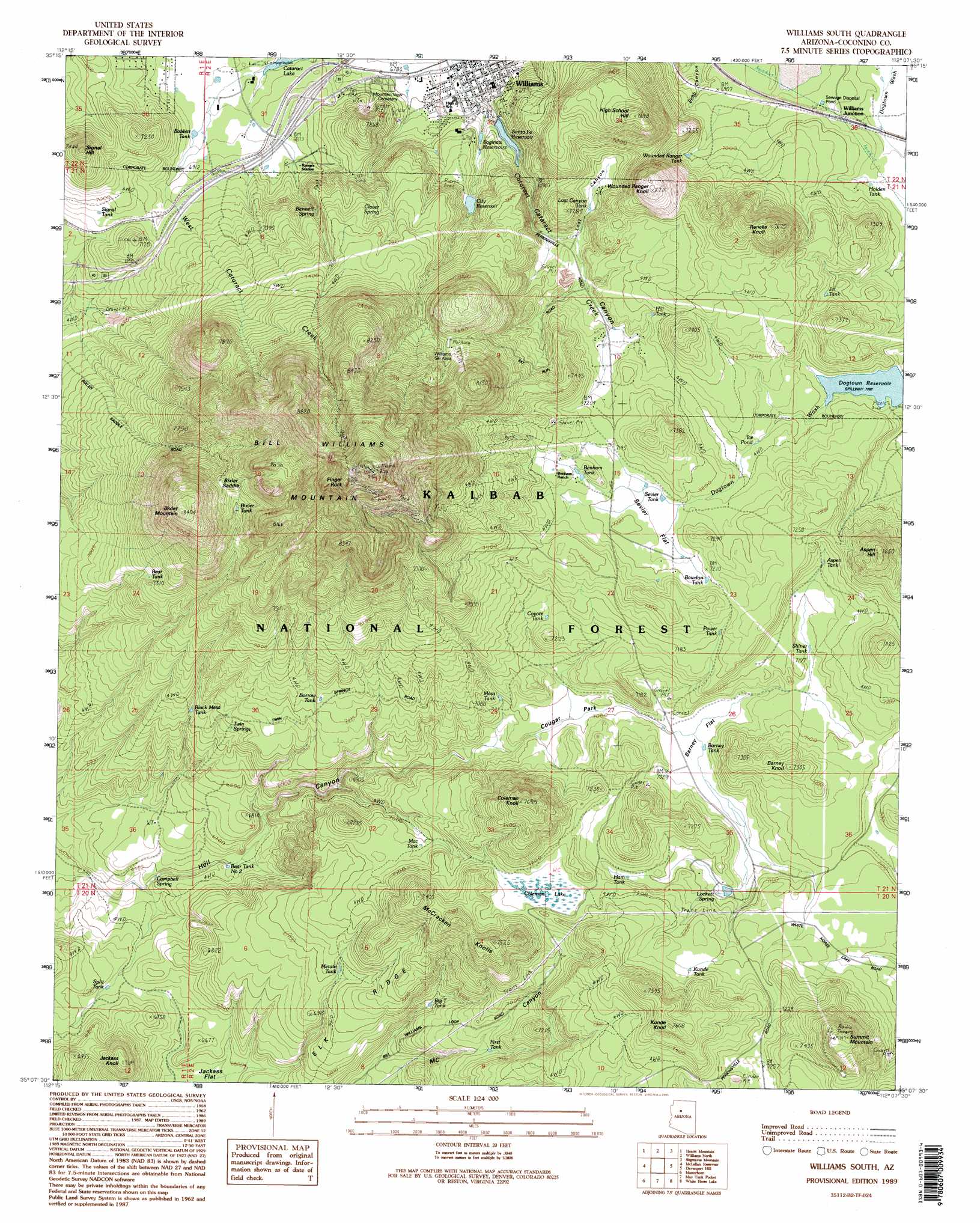
USGS Topo Quad 35112b2 - 1:24,000 scale
| Topo Map Name: | Williams South |
| USGS Topo Quad ID: | 35112b2 |
| Print Size: | ca. 21 1/4" wide x 27" high |
| Southeast Coordinates: | 35.125° N latitude / 112.125° W longitude |
| Map Center Coordinates: | 35.1875° N latitude / 112.1875° W longitude |
| U.S. State: | AZ |
| Filename: | o35112b2.jpg |
| Download Map JPG Image: | Williams South topo map 1:24,000 scale |
| Map Type: | Topographic |
| Topo Series: | 7.5´ |
| Map Scale: | 1:24,000 |
| Source of Map Images: | United States Geological Survey (USGS) |
| Alternate Map Versions: |
Williams South AZ 1989, updated 1990 Download PDF Buy paper map Williams South AZ 1989, updated 1995 Download PDF Buy paper map Williams South AZ 1989, updated 1995 Download PDF Buy paper map Williams South AZ 2012 Download PDF Buy paper map Williams South AZ 2014 Download PDF Buy paper map |
| FStopo: | US Forest Service topo Williams South is available: Download FStopo PDF Download FStopo TIF |
1:24,000 Topo Quads surrounding Williams South
Stanford Tank |
Cataract Tank |
Howard Mesa |
Squaw Mountain |
Moritz Ridge |
Fitzgerald Hill |
Hearst Mountain |
Williams North |
Sitgreaves Mountain |
Parks |
Ash Fork |
Mclellan Reservoir |
Williams South |
Davenport Hill |
Garland Prairie |
Meath Spring |
Matterhorn |
May Tank Pocket |
White Horse Lake |
Sycamore Point |
Paulden |
Hell Point |
Perkinsville |
Sycamore Basin |
Loy Butte |
> Back to 35112a1 at 1:100,000 scale
> Back to 35112a1 at 1:250,000 scale
> Back to U.S. Topo Maps home
Williams South topo map: Gazetteer
Williams South: Dams
City Dam elevation 2199m 7214′Concrete Dam elevation 2106m 6909′
Dogtown Dam elevation 2155m 7070′
Perrin Dam elevation 2089m 6853′
Railroad Dam elevation 2112m 6929′
Williams South: Flats
Barney Flat elevation 2137m 7011′Cougar Park elevation 2140m 7020′
Sevier Flat elevation 2189m 7181′
Williams South: Gaps
Bixler Saddle elevation 2366m 7762′Williams South: Lakes
Ice Pond elevation 2172m 7125′Williams South: Parks
Benham Snow Play Area elevation 2193m 7194′Dogtown Picnic Ground elevation 2175m 7135′
Williams Ski Area elevation 2394m 7854′
Williams South: Pillars
Finger Rock elevation 2728m 8950′Williams South: Populated Places
Williams elevation 2063m 6768′Williams Junction elevation 2119m 6952′
Williams South: Reservoirs
Aspen Tank elevation 2169m 7116′AZ Trick Tank elevation 2196m 7204′
Babbitt Tank elevation 2090m 6856′
Barney Tank elevation 2140m 7020′
Bear Tank elevation 2211m 7253′
Bear Tank Number Two elevation 2007m 6584′
Benham Tank elevation 2207m 7240′
Big T Tank elevation 2084m 6837′
Bixler Tank elevation 2330m 7644′
Black Mesa Tank elevation 2145m 7037′
Borrow Tank elevation 2171m 7122′
Bowdon Tank elevation 2197m 7208′
Burro Tank elevation 2049m 6722′
Campbell Tank elevation 1999m 6558′
CB Tank elevation 2152m 7060′
City Reservoir elevation 2129m 6984′
Coyote Tank elevation 2138m 7014′
Dogtown Reservoir elevation 2155m 7070′
Eagle Tank elevation 2113m 6932′
First Tank elevation 2109m 6919′
Ham Tank elevation 2169m 7116′
Holden Tank elevation 2111m 6925′
Ice Pond Tank elevation 2171m 7122′
Jct Tank elevation 2171m 7122′
JJ Tank elevation 2054m 6738′
Kunde Tank elevation 2200m 7217′
Lazy Tank elevation 2081m 6827′
Lockett Tank elevation 2161m 7089′
Lost Canyon Tank elevation 2149m 7050′
Lower Saginaw Reservoir elevation 2089m 6853′
Mac Tank elevation 2140m 7020′
Mesa Tank elevation 2148m 7047′
Metate Tank elevation 2097m 6879′
Mountain Spring Tankds elevation 2106m 6909′
Mountain Spring Tanks elevation 2106m 6909′
Power Tank elevation 2199m 7214′
RT Tank elevation 2041m 6696′
Saginaw Reservoirs (historical) elevation 2095m 6873′
Santa Fe Reservoir elevation 2092m 6863′
Sevier Tank elevation 2188m 7178′
Shiner Tank elevation 2159m 7083′
Signal Tank elevation 2122m 6961′
Split Tank elevation 2027m 6650′
Supui Tank elevation 2124m 6968′
Upper Saginaw Reservoir elevation 2106m 6909′
Wounded Ranger Tank elevation 2132m 6994′
Williams South: Springs
Bennett Spring elevation 2176m 7139′Campbell Spring elevation 1997m 6551′
Clover Spring elevation 2191m 7188′
Lockett Spring elevation 2158m 7080′
Twin Springs elevation 2131m 6991′
Williams South: Streams
West Cataract Creek elevation 2079m 6820′Williams South: Summits
Aspen Hill elevation 2330m 7644′Barney Knoll elevation 2225m 7299′
Bill Williams Mountain elevation 2795m 9169′
Bixler Mountain elevation 2556m 8385′
Coleman Knoll elevation 2331m 7647′
High School Hill elevation 2342m 7683′
Jackass Knoll elevation 2161m 7089′
Kunde Knoll elevation 2318m 7604′
McCracken Knoll Number One elevation 2264m 7427′
McCracken Knoll Number Three elevation 2293m 7522′
McCracken Knoll Number Two elevation 2264m 7427′
McCracken Knolls elevation 2296m 7532′
Reneke Knoll elevation 2328m 7637′
Signal Hill elevation 2266m 7434′
Summit Mountain elevation 2373m 7785′
Wounded Ranger Knoll elevation 2349m 7706′
Williams South: Swamps
Coleman Lake elevation 2180m 7152′Williams South: Trails
Benham National Recreation Trail elevation 2314m 7591′Benham Trail elevation 2241m 7352′
Bill Williams National Recreation Trail elevation 2367m 7765′
Bixler Saddle Trail elevation 2504m 8215′
Williams South: Valleys
Echo Canyon elevation 2094m 6870′Lost Canyon elevation 2142m 7027′
Williams South digital topo map on disk
Buy this Williams South topo map showing relief, roads, GPS coordinates and other geographical features, as a high-resolution digital map file on DVD: