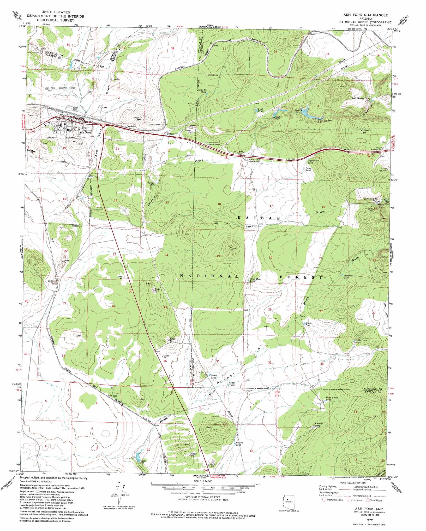
Ash Fork Topo Map Arizona
To zoom in, hover over the map of Ash Fork
USGS Topo Quad 35112b4 - 1:24,000 scale
| Topo Map Name: | Ash Fork |
| USGS Topo Quad ID: | 35112b4 |
| Print Size: | ca. 21 1/4" wide x 27" high |
| Southeast Coordinates: | 35.125° N latitude / 112.375° W longitude |
| Map Center Coordinates: | 35.1875° N latitude / 112.4375° W longitude |
| U.S. State: | AZ |
| Filename: | o35112b4.jpg |
| Download Map JPG Image: | Ash Fork topo map 1:24,000 scale |
| Map Type: | Topographic |
| Topo Series: | 7.5´ |
| Map Scale: | 1:24,000 |
| Source of Map Images: | United States Geological Survey (USGS) |
| Alternate Map Versions: |
Ash Fork AZ 1979, updated 1985 Download PDF Buy paper map Ash Fork AZ 2012 Download PDF Buy paper map Ash Fork AZ 2014 Download PDF Buy paper map |
| FStopo: | US Forest Service topo Ash Fork is available: Download FStopo PDF Download FStopo TIF |
1:24,000 Topo Quads surrounding Ash Fork
Mount Floyd |
Eagle Nest Mountain |
Stanford Tank |
Cataract Tank |
Howard Mesa |
Crookton |
Horse Trap Mesa |
Fitzgerald Hill |
Hearst Mountain |
Williams North |
Picacho Butte |
Cathedral Caves |
Ash Fork |
Mclellan Reservoir |
Williams South |
South Butte |
Picacho Butte Se |
Meath Spring |
Matterhorn |
May Tank Pocket |
Limestone Peak |
Wineglass Ranch |
Paulden |
Hell Point |
Perkinsville |
> Back to 35112a1 at 1:100,000 scale
> Back to 35112a1 at 1:250,000 scale
> Back to U.S. Topo Maps home
Ash Fork topo map: Gazetteer
Ash Fork: Airports
Ash Fork Landing Strip elevation 1567m 5141′Ash Fork: Crossings
Country Line Interchange elevation 1601m 5252′East Ash Fork Interchange elevation 1561m 5121′
Monte Carlo Interchange elevation 1618m 5308′
Welch Interchange elevation 1783m 5849′
West Ash Fork Interchange elevation 1566m 5137′
Ash Fork: Dams
Irishman Dam elevation 1578m 5177′Meath Dam elevation 1557m 5108′
Steel Dam elevation 1647m 5403′
Stone Dam elevation 1673m 5488′
Ash Fork: Flats
Putney Flat elevation 1586m 5203′Ash Fork: Populated Places
Ash Fork elevation 1566m 5137′Daze elevation 1738m 5702′
Ash Fork: Post Offices
Ash Fork Post Office elevation 1577m 5173′Ash Fork: Reservoirs
Antelope Tank elevation 1714m 5623′Ash Fork Santa Fe Railroad Company Water Tank elevation 1567m 5141′
Bridge Tank elevation 1703m 5587′
Cramer Tank elevation 1611m 5285′
Culvert Tank elevation 1751m 5744′
Depression Tank elevation 1663m 5456′
Green Tank elevation 1580m 5183′
Hells Uncle Tank elevation 1665m 5462′
Larry Tank elevation 1652m 5419′
Little Rain Tank elevation 1612m 5288′
Little Tank elevation 1592m 5223′
Masonry Number Two Reservoir elevation 1673m 5488′
Meath Tank elevation 1619m 5311′
Merchant Tank elevation 1656m 5433′
North Tank elevation 1576m 5170′
Perrin Tank elevation 1708m 5603′
Prairie Tank elevation 1573m 5160′
Rock Tank elevation 1720m 5643′
Rods Winter Camp Tank elevation 1717m 5633′
Santa Fe Tank elevation 1626m 5334′
Steel Crater elevation 1664m 5459′
Steel Dam Reservoir elevation 1647m 5403′
Wood Camp Tank elevation 1618m 5308′
Ash Fork: Streams
Johnson Creek elevation 1547m 5075′Ash Fork: Valleys
Johnson Canyon elevation 1647m 5403′Perrin Draw elevation 1546m 5072′
Ash Fork digital topo map on disk
Buy this Ash Fork topo map showing relief, roads, GPS coordinates and other geographical features, as a high-resolution digital map file on DVD: