Penitentiary Mountain Topo Map Arizona
To zoom in, hover over the map of Penitentiary Mountain
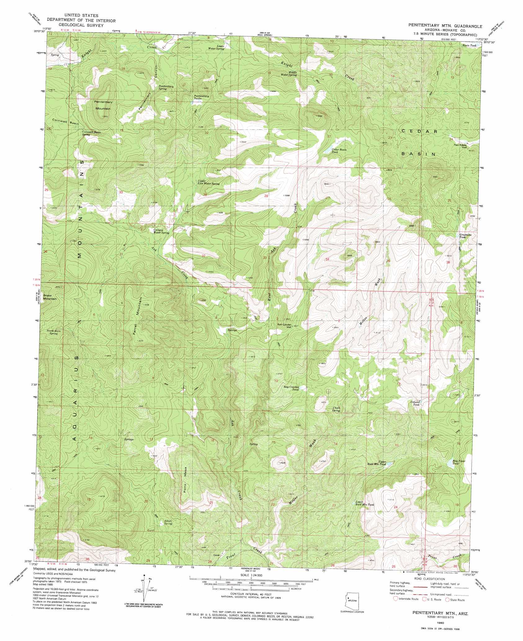
USGS Topo Quad 35113a4 - 1:24,000 scale
| Topo Map Name: | Penitentiary Mountain |
| USGS Topo Quad ID: | 35113a4 |
| Print Size: | ca. 21 1/4" wide x 27" high |
| Southeast Coordinates: | 35° N latitude / 113.375° W longitude |
| Map Center Coordinates: | 35.0625° N latitude / 113.4375° W longitude |
| U.S. State: | AZ |
| Filename: | o35113a4.jpg |
| Download Map JPG Image: | Penitentiary Mountain topo map 1:24,000 scale |
| Map Type: | Topographic |
| Topo Series: | 7.5´ |
| Map Scale: | 1:24,000 |
| Source of Map Images: | United States Geological Survey (USGS) |
| Alternate Map Versions: |
Penitentiary Mtn AZ 1980, updated 1980 Download PDF Buy paper map Penitentiary Mountain AZ 2011 Download PDF Buy paper map Penitentiary Mountain AZ 2014 Download PDF Buy paper map |
1:24,000 Topo Quads surrounding Penitentiary Mountain
Hackberry |
Valentine Se |
Tuckayou Spring |
Blye Canyon Se |
Sugarloaf Peak |
Tin Mountain Nw |
Tin Mountain |
Bull Spring |
Fort Rock Ranch |
Cross Mountain |
Bottleneck Wash |
Austin Peak |
Penitentiary Mountain |
Devils Hump |
Anvil Rock Ranch |
Pilgrim Wash |
Tom Brown Canyon |
Gonzales Wash |
Mohon Peak |
Sunrise Peak |
Gunsight Canyon |
Tule Wash |
Cedar Basin |
Pilot Knob |
Burro Mesa |
> Back to 35113a1 at 1:100,000 scale
> Back to 35112a1 at 1:250,000 scale
> Back to U.S. Topo Maps home
Penitentiary Mountain topo map: Gazetteer
Penitentiary Mountain: Basins
Cedar Basin elevation 1628m 5341′Cornwall Basin elevation 1352m 4435′
Penitentiary Mountain: Ranges
Aquarius Mountains elevation 1400m 4593′Penitentiary Mountain: Reservoirs
Basin Tank elevation 1619m 5311′Cedar Basin Tank elevation 1617m 5305′
Grapevine Tank elevation 1558m 5111′
Hay Fever Tank elevation 1417m 4648′
Lower Bald Mountain Tank elevation 1303m 4274′
Penitentiary Tanks elevation 1485m 4872′
Upper Bald Mountain Tank elevation 1336m 4383′
Penitentiary Mountain: Springs
Alkali Spring elevation 1182m 3877′Campos Water Spring elevation 1394m 4573′
Cement Tank elevation 1402m 4599′
Chalk Spring elevation 1331m 4366′
Cornwall Basin Spring elevation 1374m 4507′
Lower Water Spring elevation 1379m 4524′
Middle Water Spring elevation 1438m 4717′
North Burn Spring elevation 1478m 4849′
Penitentiary Spring elevation 1366m 4481′
Ray Cowden Tank elevation 1362m 4468′
Upper Live Water Spring elevation 1427m 4681′
Penitentiary Mountain: Streams
Ash Creek elevation 1167m 3828′East Ash Creek elevation 1317m 4320′
Penitentiary Mountain: Summits
Farrel Mountain elevation 1610m 5282′Penitentiary Mountain elevation 1618m 5308′
Pony Mesa elevation 1466m 4809′
Penitentiary Mountain: Valleys
McGee Wash elevation 1158m 3799′Penitentiary Mountain: Wells
Pasa Robles Well elevation 1580m 5183′Ruth Cowden Well elevation 1412m 4632′
Penitentiary Mountain digital topo map on disk
Buy this Penitentiary Mountain topo map showing relief, roads, GPS coordinates and other geographical features, as a high-resolution digital map file on DVD: