Valentine Topo Map Arizona
To zoom in, hover over the map of Valentine
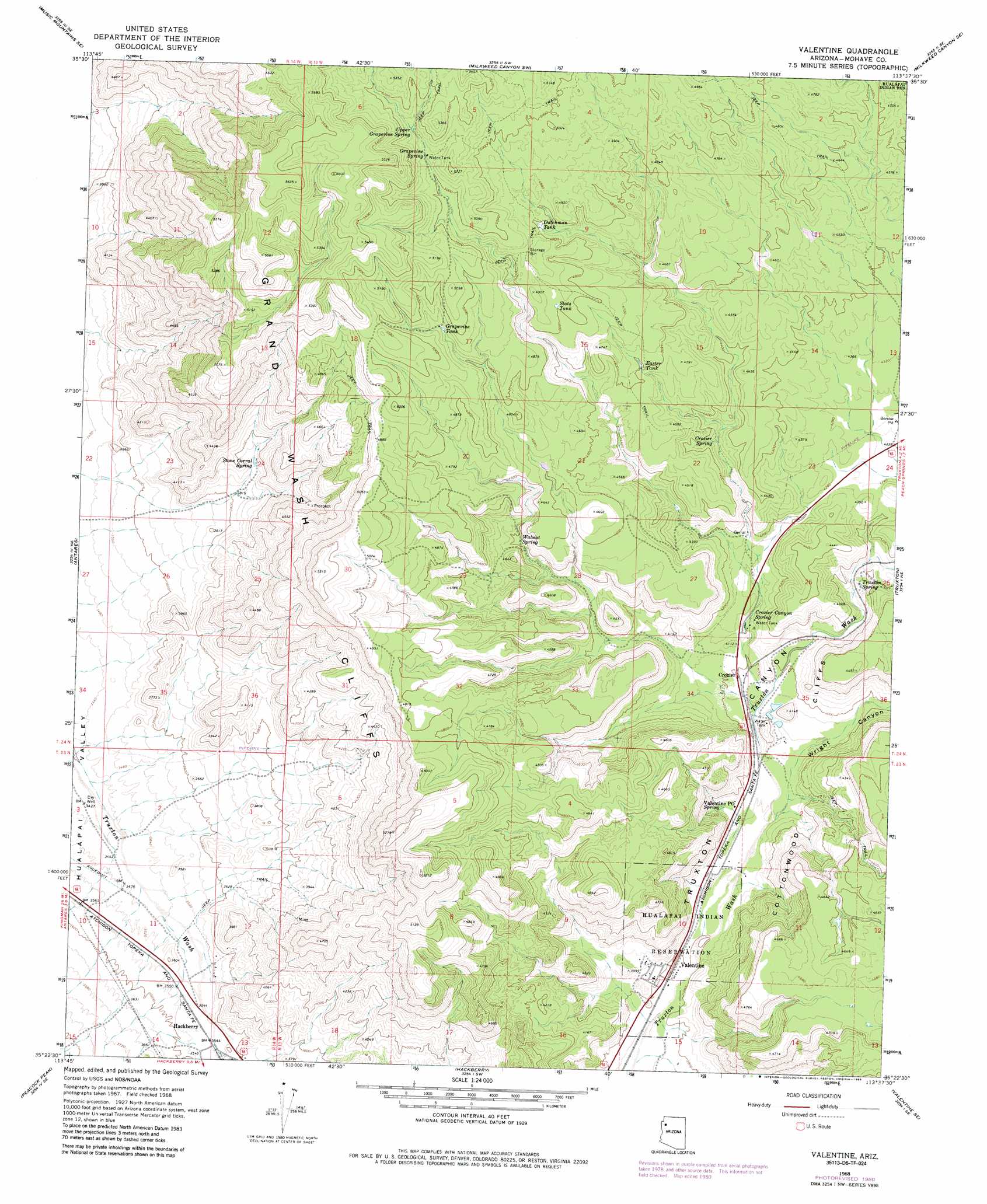
USGS Topo Quad 35113d6 - 1:24,000 scale
| Topo Map Name: | Valentine |
| USGS Topo Quad ID: | 35113d6 |
| Print Size: | ca. 21 1/4" wide x 27" high |
| Southeast Coordinates: | 35.375° N latitude / 113.625° W longitude |
| Map Center Coordinates: | 35.4375° N latitude / 113.6875° W longitude |
| U.S. State: | AZ |
| Filename: | o35113d6.jpg |
| Download Map JPG Image: | Valentine topo map 1:24,000 scale |
| Map Type: | Topographic |
| Topo Series: | 7.5´ |
| Map Scale: | 1:24,000 |
| Source of Map Images: | United States Geological Survey (USGS) |
| Alternate Map Versions: |
Valentine AZ 1968, updated 1971 Download PDF Buy paper map Valentine AZ 1968, updated 1985 Download PDF Buy paper map Valentine AZ 2011 Download PDF Buy paper map Valentine AZ 2014 Download PDF Buy paper map |
1:24,000 Topo Quads surrounding Valentine
Music Mountains Nw |
Music Mountains Ne |
Milkweed Canyon Nw |
Hindu Canyon |
Peach Springs Canyon |
Music Mountains Sw |
Music Mountains Se |
Milkweed Canyon Sw |
Milkweed Canyon Se |
Peach Springs |
Long Mountain |
Antares |
Valentine |
Truxton |
Cherokee Point |
Kingman Airport |
Peacock Peak |
Hackberry |
Valentine Se |
Tuckayou Spring |
Rattlesnake Hill |
Hualapai Spring |
Tin Mountain Nw |
Tin Mountain |
Bull Spring |
> Back to 35113a1 at 1:100,000 scale
> Back to 35112a1 at 1:250,000 scale
> Back to U.S. Topo Maps home
Valentine topo map: Gazetteer
Valentine: Populated Places
Crozier elevation 1220m 4002′Valentine elevation 1159m 3802′
Valentine: Post Offices
Valentine Post Office elevation 1190m 3904′Valentine: Reservoirs
Dutchman Tank elevation 1458m 4783′Easter Tank elevation 1402m 4599′
Grapevine Tank elevation 1485m 4872′
Slats Tank elevation 1465m 4806′
Valentine: Springs
Crozier Canyon Spring elevation 1239m 4064′Crozier Spring elevation 1316m 4317′
Grapevine Spring elevation 1537m 5042′
Stone Corral Spring elevation 1193m 3914′
Truxton Spring elevation 1245m 4084′
Upper Grapevine Spring elevation 1552m 5091′
Walnut Spring elevation 1337m 4386′
Valentine: Valleys
Wright Canyon elevation 1193m 3914′Valentine digital topo map on disk
Buy this Valentine topo map showing relief, roads, GPS coordinates and other geographical features, as a high-resolution digital map file on DVD: