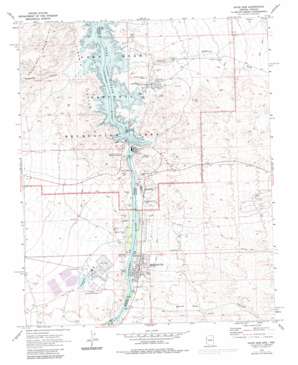
Davis Dam Topo Map Arizona
To zoom in, hover over the map of Davis Dam
USGS Topo Quad 35114b5 - 1:24,000 scale
| Topo Map Name: | Davis Dam |
| USGS Topo Quad ID: | 35114b5 |
| Print Size: | ca. 21 1/4" wide x 27" high |
| Southeast Coordinates: | 35.125° N latitude / 114.5° W longitude |
| Map Center Coordinates: | 35.1875° N latitude / 114.5625° W longitude |
| U.S. States: | AZ, NV |
| Filename: | o35114b5.jpg |
| Download Map JPG Image: | Davis Dam topo map 1:24,000 scale |
| Map Type: | Topographic |
| Topo Series: | 7.5´ |
| Map Scale: | 1:24,000 |
| Source of Map Images: | United States Geological Survey (USGS) |
| Alternate Map Versions: |
Davis Dam AZ 1970, updated 1973 Download PDF Buy paper map Davis Dam AZ 1970, updated 1982 Download PDF Buy paper map Davis Dam AZ 1970, updated 1983 Download PDF Buy paper map Davis Dam AZ 2011 Download PDF Buy paper map Davis Dam AZ 2014 Download PDF Buy paper map |
1:24,000 Topo Quads surrounding Davis Dam
> Back to 35114a1 at 1:100,000 scale
> Back to 35114a1 at 1:250,000 scale
> Back to U.S. Topo Maps home
Davis Dam topo map: Gazetteer
Davis Dam: Airports
Bullhead City Airport elevation 169m 554′Laughlin/Bullhead City Airport elevation 193m 633′
Sce Mohave Heliport elevation 215m 705′
Davis Dam: Bays
Arrowhead Cove elevation 197m 646′Beaver Cove elevation 197m 646′
Bergemeyer Cove elevation 197m 646′
Bullhead Cove elevation 197m 646′
Cabinsite Cove elevation 197m 646′
Davis Cove elevation 197m 646′
Dead Elephant Cove elevation 198m 649′
Forked Coves elevation 197m 646′
Jackrabbit Cove elevation 197m 646′
Katherine Landing elevation 197m 646′
Little Stopsign Cove elevation 197m 646′
Miners Cove elevation 197m 646′
Mohave Pass elevation 197m 646′
Navajo Cove elevation 197m 646′
Nevada Telephone Cove elevation 197m 646′
Newberry Cove elevation 197m 646′
Ninety Foot Cove elevation 197m 646′
Paiute Cove elevation 197m 646′
Rock House Cove elevation 227m 744′
Ryolite Cove elevation 197m 646′
Sand Cove elevation 197m 646′
Ski Cove elevation 197m 646′
Ski Pass elevation 197m 646′
Sour Dough Cove elevation 197m 646′
Stopsign Cove elevation 197m 646′
Telephone Cove Arizona - North elevation 197m 646′
Telephone Cove Arizona - South elevation 197m 646′
Turkey Cove elevation 197m 646′
Davis Dam: Bridges
Forbay Bridge elevation 197m 646′Davis Dam: Dams
Davis Dam elevation 194m 636′Davis Dam elevation 197m 646′
Evaporation Pond Number 6A Dam elevation 208m 682′
Evaporation Pond Number 6B Dam elevation 214m 702′
Evaporation Pond Number 6C Dam elevation 221m 725′
Evaporation Pond Number Five Dam elevation 227m 744′
Evaporation Pond Number Four Dam elevation 210m 688′
Evaporation Pond Number Three Dam elevation 209m 685′
Evaporation Pond Number Two Dam elevation 213m 698′
Mohave Generating Station Dam elevation 183m 600′
Davis Dam: Islands
Bulls Head Rock elevation 206m 675′Davis Dam: Mines
Homestake Group Mine elevation 274m 898′Katherine Extension Mine elevation 374m 1227′
Katherine Mine elevation 283m 928′
Wiley Inspiration Mine elevation 290m 951′
Davis Dam: Parks
Laughlin Park elevation 280m 918′Mountain View Park elevation 274m 898′
William Bennett Park elevation 266m 872′
Davis Dam: Pillars
Inscription Rock elevation 185m 606′Pyramid Rock elevation 197m 646′
Davis Dam: Populated Places
Bullhead City elevation 170m 557′Davis Dam elevation 162m 531′
Katherine elevation 209m 685′
Laughlin elevation 170m 557′
Davis Dam: Post Offices
Bullhead City Post Office elevation 170m 557′Davis Dam Post Office (historical) elevation 166m 544′
Laughlin Rural Branch Post Office elevation 170m 557′
Davis Dam: Reservoirs
Lake Mohave elevation 194m 636′Mohave Generating Station Reservoir elevation 183m 600′
Davis Dam: Streams
Katherine Wash elevation 197m 646′Silver Creek elevation 152m 498′
Silver Creek Wash elevation 0m 0′
Davis Dam: Summits
Loaf Rock elevation 246m 807′Davis Dam: Valleys
Bullhead Canyon elevation 153m 501′Grapevine Canyon elevation 199m 652′
Pyramid Canyon elevation 197m 646′
Pyramid Canyon elevation 197m 646′
Secret Pass Canyon elevation 0m 0′
Davis Dam digital topo map on disk
Buy this Davis Dam topo map showing relief, roads, GPS coordinates and other geographical features, as a high-resolution digital map file on DVD:
Southern Sierra Nevada, California & Southern Nevada
Buy digital topo maps: Southern Sierra Nevada, California & Southern Nevada


