Stockton Hill Topo Map Arizona
To zoom in, hover over the map of Stockton Hill
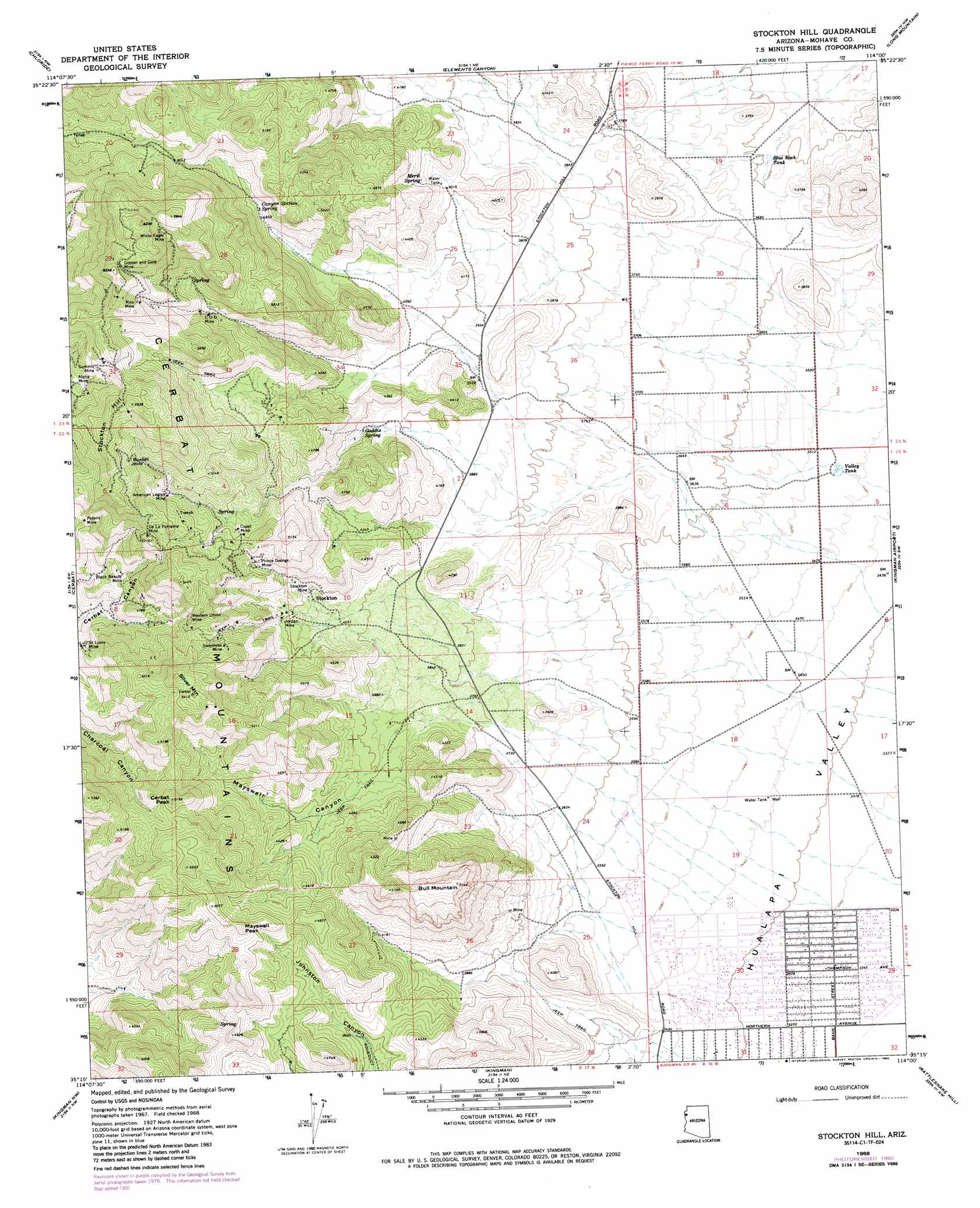
USGS Topo Quad 35114c1 - 1:24,000 scale
| Topo Map Name: | Stockton Hill |
| USGS Topo Quad ID: | 35114c1 |
| Print Size: | ca. 21 1/4" wide x 27" high |
| Southeast Coordinates: | 35.25° N latitude / 114° W longitude |
| Map Center Coordinates: | 35.3125° N latitude / 114.0625° W longitude |
| U.S. State: | AZ |
| Filename: | o35114c1.jpg |
| Download Map JPG Image: | Stockton Hill topo map 1:24,000 scale |
| Map Type: | Topographic |
| Topo Series: | 7.5´ |
| Map Scale: | 1:24,000 |
| Source of Map Images: | United States Geological Survey (USGS) |
| Alternate Map Versions: |
Stockton Hill AZ 1968, updated 1971 Download PDF Buy paper map Stockton Hill AZ 1968, updated 1980 Download PDF Buy paper map Stockton Hill AZ 1968, updated 1985 Download PDF Buy paper map Stockton Hill AZ 1968, updated 1985 Download PDF Buy paper map Stockton Hill AZ 2011 Download PDF Buy paper map Stockton Hill AZ 2014 Download PDF Buy paper map |
1:24,000 Topo Quads surrounding Stockton Hill
Dolan Springs |
Mount Tipton |
Mount Tipton Se |
Music Mountains Sw |
Music Mountains Se |
Grasshopper Junction |
Chloride |
Elements Canyon |
Long Mountain |
Antares |
Grasshopper Junction Se |
Cerbat |
Stockton Hill |
Kingman Airport |
Peacock Peak |
Secret Pass |
Kingman Nw |
Kingman |
Rattlesnake Hill |
Hualapai Spring |
Mount Nutt |
Kingman Sw |
Kingman Se |
Hualapai Peak |
Dean Peak |
> Back to 35114a1 at 1:100,000 scale
> Back to 35114a1 at 1:250,000 scale
> Back to U.S. Topo Maps home
Stockton Hill topo map: Gazetteer
Stockton Hill: Mines
Alpha Mine elevation 1557m 5108′American Legion Mine elevation 1511m 4957′
Black Beauty Mine elevation 1406m 4612′
Bluebell Mine elevation 1666m 5465′
C O D Mine elevation 1530m 5019′
Copper and Gold Mine elevation 1797m 5895′
Cupel Mine elevation 1453m 4767′
De La Fontaine Mine elevation 1612m 5288′
Jordan Mine elevation 1288m 4225′
Knight Hawk Mine elevation 1701m 5580′
McClellan Mine elevation 1416m 4645′
Polaris Mine elevation 1487m 4878′
Prince George Mine elevation 1409m 4622′
Rico Mine elevation 1710m 5610′
Saint Louis Mine elevation 0m 0′
Sixtythree Mine elevation 0m 0′
Stockton Mine elevation 1282m 4206′
Summit Mine elevation 1632m 5354′
Western Union Mine elevation 1497m 4911′
White Eagle Mine elevation 1725m 5659′
Stockton Hill: Parks
Neal Butler Park elevation 1026m 3366′Stockton Hill: Populated Places
New Kingman elevation 1023m 3356′Stockton elevation 1270m 4166′
Stockton Hill: Reservoirs
Blue Rock Tank elevation 1092m 3582′Valley Tank elevation 1064m 3490′
Stockton Hill: Springs
C O D Spring elevation 1308m 4291′Canyon Station Spring elevation 1373m 4504′
Gaddis Spring elevation 1256m 4120′
Merit Spring elevation 1266m 4153′
Stockton Hill: Summits
Bull Mountain elevation 1567m 5141′Cerbat Peak elevation 1575m 5167′
Mayswell Peak elevation 1572m 5157′
Silver Mountain elevation 0m 0′
Stockton Hill elevation 1808m 5931′
Stockton Hill: Valleys
Mayswell Canyon elevation 1183m 3881′Stockton Hill digital topo map on disk
Buy this Stockton Hill topo map showing relief, roads, GPS coordinates and other geographical features, as a high-resolution digital map file on DVD:
Southern Sierra Nevada, California & Southern Nevada
Buy digital topo maps: Southern Sierra Nevada, California & Southern Nevada