Spirit Mountain Topo Map Nevada
To zoom in, hover over the map of Spirit Mountain
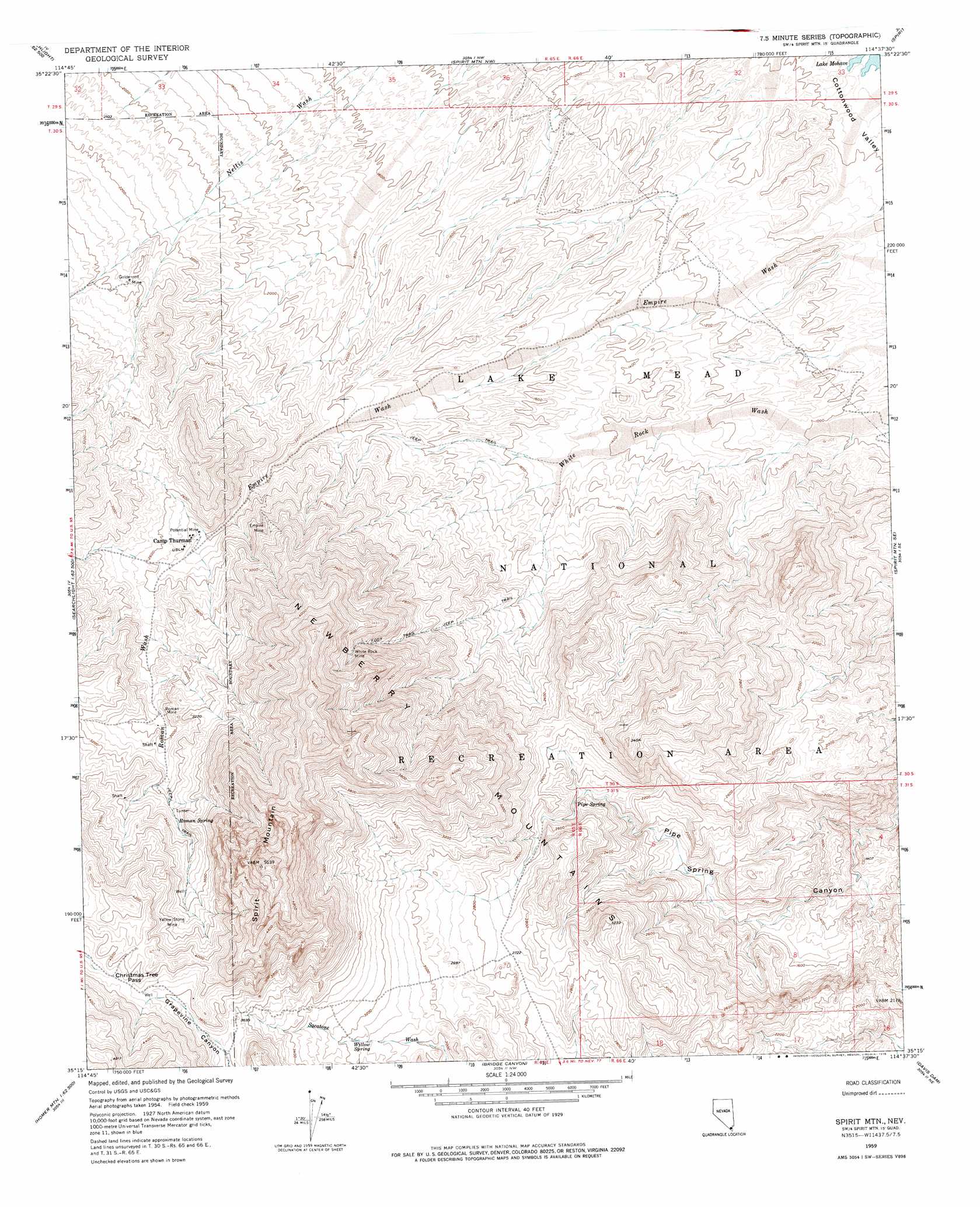
USGS Topo Quad 35114c6 - 1:24,000 scale
| Topo Map Name: | Spirit Mountain |
| USGS Topo Quad ID: | 35114c6 |
| Print Size: | ca. 21 1/4" wide x 27" high |
| Southeast Coordinates: | 35.25° N latitude / 114.625° W longitude |
| Map Center Coordinates: | 35.3125° N latitude / 114.6875° W longitude |
| U.S. State: | NV |
| Filename: | o35114c6.jpg |
| Download Map JPG Image: | Spirit Mountain topo map 1:24,000 scale |
| Map Type: | Topographic |
| Topo Series: | 7.5´ |
| Map Scale: | 1:24,000 |
| Source of Map Images: | United States Geological Survey (USGS) |
| Alternate Map Versions: |
Spirit Mtn NV 1959, updated 1960 Download PDF Buy paper map Spirit Mtn NV 1959, updated 1960 Download PDF Buy paper map Spirit Mtn NV 1959, updated 1976 Download PDF Buy paper map Spirit Mtn NV 1959, updated 1976 Download PDF Buy paper map Spirit Mountain NV 2012 Download PDF Buy paper map Spirit Mountain NV 2014 Download PDF Buy paper map |
1:24,000 Topo Quads surrounding Spirit Mountain
Nelson Sw |
Ireteba Peaks |
Mount Davis |
Mount Perkins |
Middle Water Spring |
Searchlight |
Fourth Of July Mountain |
Spirit Mountain Nw |
Spirit Mountain Ne |
Grasshopper Junction Nw |
Tenmile Well |
Searchlight Se |
Spirit Mountain |
Spirit Mountain Se |
Burns Spring |
West Of Juniper Mine |
Juniper Mine |
Bridge Canyon |
Davis Dam |
Union Pass |
Homer Mountain |
East Of Homer Mountain |
Mount Manchester |
Davis Dam Se |
Oatman |
> Back to 35114a1 at 1:100,000 scale
> Back to 35114a1 at 1:250,000 scale
> Back to U.S. Topo Maps home
Spirit Mountain topo map: Gazetteer
Spirit Mountain: Gaps
Christmas Tree Pass elevation 1204m 3950′Spirit Mountain: Mines
Empire Mine elevation 787m 2582′Goldenrod Mine elevation 720m 2362′
Jackdaw Group Mine elevation 754m 2473′
Potential Mine elevation 742m 2434′
Roman Mine elevation 897m 2942′
White Rock Mine elevation 1095m 3592′
Yellow Stone Mine elevation 1127m 3697′
Spirit Mountain: Springs
Discovery Spring elevation 820m 2690′Pipe Spring elevation 716m 2349′
Roman Spring elevation 996m 3267′
Willow Spring elevation 962m 3156′
Spirit Mountain: Streams
Roman Wash elevation 792m 2598′Spirit Mountain: Summits
Devils Thumb elevation 1574m 5164′Mount Newberry elevation 1092m 3582′
North Peak elevation 1497m 4911′
Spirit Mountain elevation 1687m 5534′
Spirit Mountain digital topo map on disk
Buy this Spirit Mountain topo map showing relief, roads, GPS coordinates and other geographical features, as a high-resolution digital map file on DVD:
Southern Sierra Nevada, California & Southern Nevada
Buy digital topo maps: Southern Sierra Nevada, California & Southern Nevada