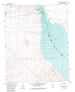
Spirit Mountain Nw Topo Map Nevada
To zoom in, hover over the map of Spirit Mountain Nw
USGS Topo Quad 35114d6 - 1:24,000 scale
| Topo Map Name: | Spirit Mountain Nw |
| USGS Topo Quad ID: | 35114d6 |
| Print Size: | ca. 21 1/4" wide x 27" high |
| Southeast Coordinates: | 35.375° N latitude / 114.625° W longitude |
| Map Center Coordinates: | 35.4375° N latitude / 114.6875° W longitude |
| U.S. States: | NV, AZ |
| Filename: | o35114d6.jpg |
| Download Map JPG Image: | Spirit Mountain Nw topo map 1:24,000 scale |
| Map Type: | Topographic |
| Topo Series: | 7.5´ |
| Map Scale: | 1:24,000 |
| Source of Map Images: | United States Geological Survey (USGS) |
| Alternate Map Versions: |
Spirit Mtn NW NV 1959, updated 1960 Download PDF Buy paper map Spirit Mtn NW NV 1959, updated 1984 Download PDF Buy paper map Spirit Mountain NW NV 2012 Download PDF Buy paper map Spirit Mountain NW NV 2014 Download PDF Buy paper map |
1:24,000 Topo Quads surrounding Spirit Mountain Nw
> Back to 35114a1 at 1:100,000 scale
> Back to 35114a1 at 1:250,000 scale
> Back to U.S. Topo Maps home
Spirit Mountain Nw topo map: Gazetteer
Spirit Mountain Nw: Airports
Cottonwood Landing Field elevation 206m 675′Spirit Mountain Nw: Areas
Cottonwood East Area elevation 197m 646′Six Mile Area elevation 197m 646′
Spirit Mountain Nw: Bays
Airport Cove elevation 197m 646′Bill Gayes Cove elevation 197m 646′
Box Cove elevation 197m 646′
Carp Cove elevation 197m 646′
Cottontail Cove elevation 197m 646′
Cottonwood Cove elevation 197m 646′
Cottonwood Island Cove elevation 197m 646′
Cottonwood Valley Cove elevation 197m 646′
Dead Cove elevation 197m 646′
Finger Cove elevation 200m 656′
Gremlin Cove elevation 197m 646′
Hog Farm Cove elevation 197m 646′
Levi Cove elevation 197m 646′
Lost Cove elevation 197m 646′
Mesa Cove elevation 197m 646′
Mesquite Cove elevation 197m 646′
Nellis Cove elevation 197m 646′
Nine Mile Coves elevation 197m 646′
North Basin Light Cove elevation 197m 646′
Pot Cove elevation 197m 646′
Sandy Point Cove elevation 197m 646′
Six Mile Cove elevation 197m 646′
Ski Cove elevation 197m 646′
Tequila Cove elevation 197m 646′
Three Sisters Cove elevation 197m 646′
Water Wheel Cove elevation 197m 646′
Windmill Cove elevation 197m 646′
Spirit Mountain Nw: Islands
Cottonwood Island (historical) elevation 197m 646′Spirit Mountain Nw: Post Offices
Cottonwood Cove Rural Branch Post Office elevation 200m 656′Spirit Mountain Nw: Rapids
Five Rapids (historical) elevation 197m 646′Spirit Mountain Nw: Streams
Nellis Wash elevation 198m 649′Spirit Mountain Nw: Valleys
Cottonwood Valley elevation 236m 774′Spirit Mountain Nw digital topo map on disk
Buy this Spirit Mountain Nw topo map showing relief, roads, GPS coordinates and other geographical features, as a high-resolution digital map file on DVD:
Southern Sierra Nevada, California & Southern Nevada
Buy digital topo maps: Southern Sierra Nevada, California & Southern Nevada


