Columbia Mountain Topo Map California
To zoom in, hover over the map of Columbia Mountain
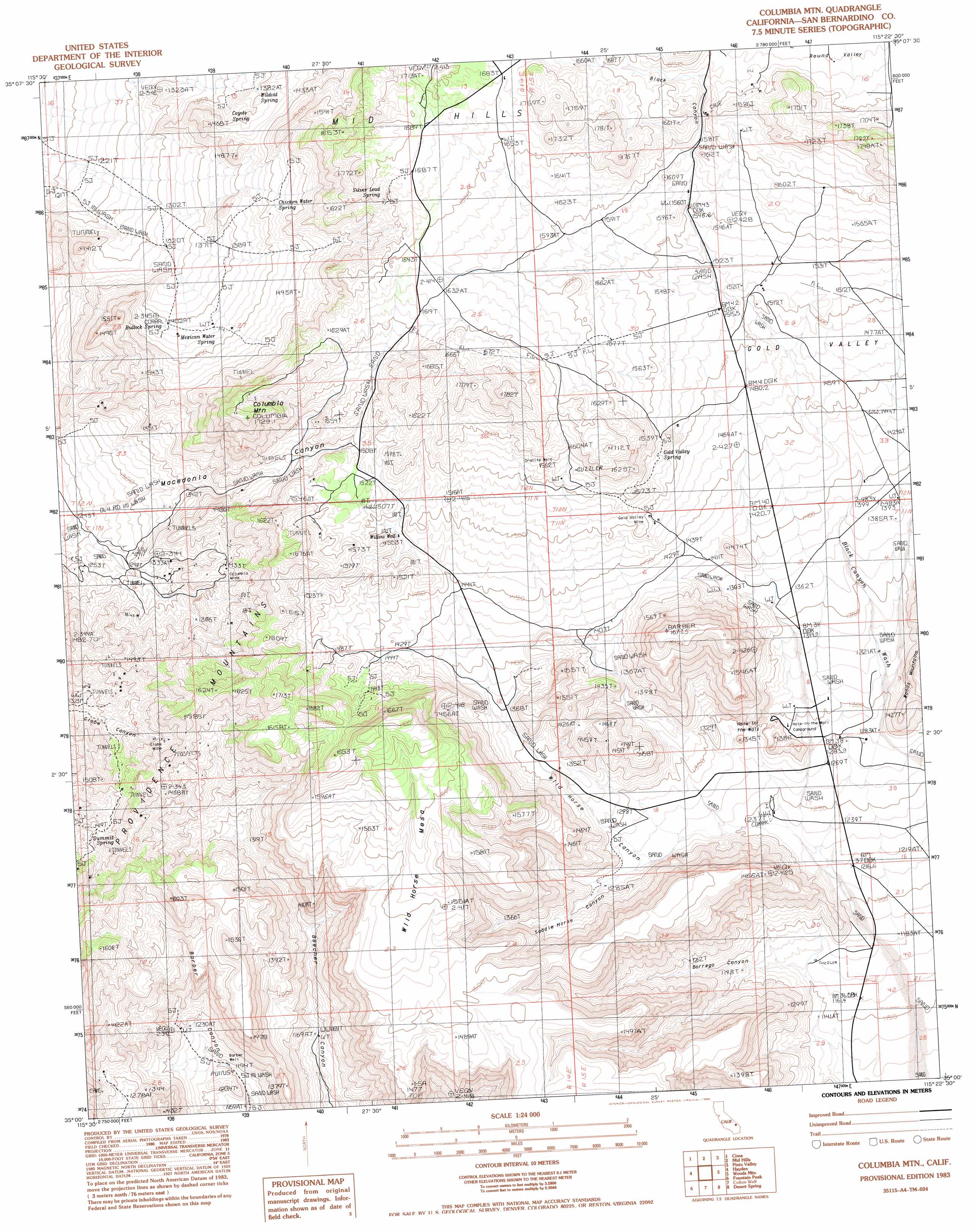
USGS Topo Quad 35115a4 - 1:24,000 scale
| Topo Map Name: | Columbia Mountain |
| USGS Topo Quad ID: | 35115a4 |
| Print Size: | ca. 21 1/4" wide x 27" high |
| Southeast Coordinates: | 35° N latitude / 115.375° W longitude |
| Map Center Coordinates: | 35.0625° N latitude / 115.4375° W longitude |
| U.S. State: | CA |
| Filename: | o35115a4.jpg |
| Download Map JPG Image: | Columbia Mountain topo map 1:24,000 scale |
| Map Type: | Topographic |
| Topo Series: | 7.5´ |
| Map Scale: | 1:24,000 |
| Source of Map Images: | United States Geological Survey (USGS) |
| Alternate Map Versions: |
Columbia Mtn CA 1983, updated 1983 Download PDF Buy paper map Columbia Mtn. CA 1983, updated 1986 Download PDF Buy paper map Columbia Mountain CA 2012 Download PDF Buy paper map Columbia Mountain CA 2015 Download PDF Buy paper map |
1:24,000 Topo Quads surrounding Columbia Mountain
Cow Cove |
Cima Dome |
Joshua |
Ivanpah |
Castle Peaks |
Marl Mountains |
Cima |
Mid Hills |
Pinto Valley |
Grotto Hills |
Kelso |
Hayden |
Columbia Mountain |
Woods Mountains |
Hackberry Mountain |
Kelso Dunes |
Fountain Peak |
Colton Well |
Desert Spring |
Fenner Hills |
Bighorn Basin |
Van Winkle Spring |
West Of Blind Hills |
Blind Hills |
Fenner |
> Back to 35115a1 at 1:100,000 scale
> Back to 35114a1 at 1:250,000 scale
> Back to U.S. Topo Maps home
Columbia Mountain topo map: Gazetteer
Columbia Mountain: Gaps
Hole-in-the Wall elevation 1300m 4265′Columbia Mountain: Mines
Columbia Mine elevation 1430m 4691′Globe Mine elevation 1481m 4858′
Gold Valley Mine elevation 1507m 4944′
Columbia Mountain: Springs
Bullock Spring elevation 1411m 4629′Chicken Water Spring elevation 1464m 4803′
Coyote Spring elevation 1360m 4461′
Gold Valley Spring elevation 1554m 5098′
Mexican Water Spring elevation 1428m 4685′
Silver Lead Spring elevation 1618m 5308′
Summit Spring elevation 1432m 4698′
Wildcat Spring elevation 1380m 4527′
Columbia Mountain: Summits
Columbia Mountain elevation 1717m 5633′Little Thorne Mountains elevation 1780m 5839′
Wild Horse Mesa elevation 1581m 5187′
Columbia Mountain: Valleys
Black Canyon elevation 1273m 4176′Borrego Canyon elevation 1155m 3789′
Gold Valley elevation 1355m 4445′
Saddle Horse Canyon elevation 1280m 4199′
Wild Horse Canyon elevation 1129m 3704′
Columbia Mountain: Wells
Barber Well elevation 1218m 3996′Granite Well elevation 1561m 5121′
Willow Well elevation 1480m 4855′
Columbia Mountain digital topo map on disk
Buy this Columbia Mountain topo map showing relief, roads, GPS coordinates and other geographical features, as a high-resolution digital map file on DVD:
Southern Sierra Nevada, California & Southern Nevada
Buy digital topo maps: Southern Sierra Nevada, California & Southern Nevada