Sheep Creek Spring Topo Map California
To zoom in, hover over the map of Sheep Creek Spring
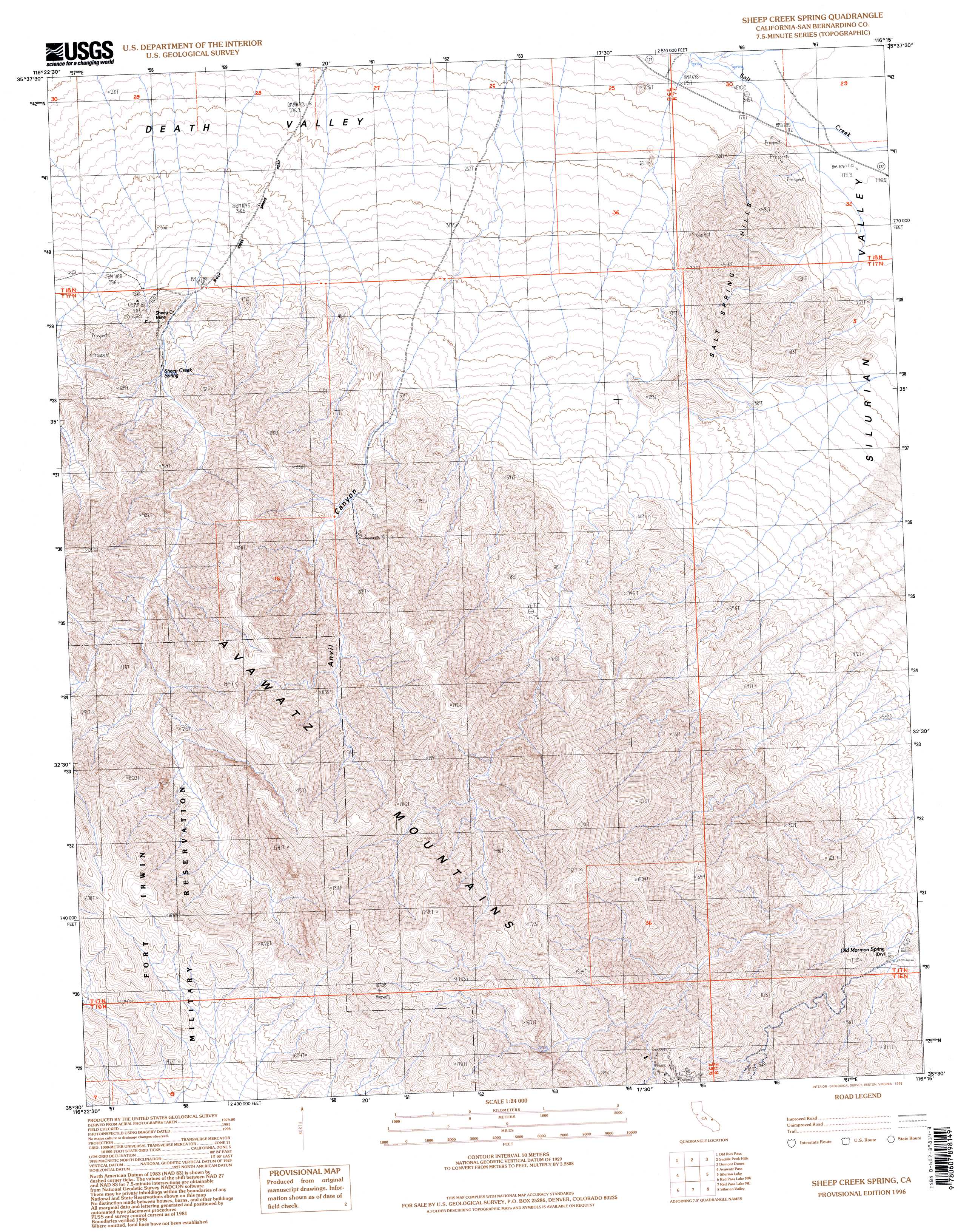
USGS Topo Quad 35116e3 - 1:24,000 scale
| Topo Map Name: | Sheep Creek Spring |
| USGS Topo Quad ID: | 35116e3 |
| Print Size: | ca. 21 1/4" wide x 27" high |
| Southeast Coordinates: | 35.5° N latitude / 116.25° W longitude |
| Map Center Coordinates: | 35.5625° N latitude / 116.3125° W longitude |
| U.S. State: | CA |
| Filename: | o35116e3.jpg |
| Download Map JPG Image: | Sheep Creek Spring topo map 1:24,000 scale |
| Map Type: | Topographic |
| Topo Series: | 7.5´ |
| Map Scale: | 1:24,000 |
| Source of Map Images: | United States Geological Survey (USGS) |
| Alternate Map Versions: |
Sheep Creek Spring CA 1985, updated 1985 Download PDF Buy paper map Sheep Creek Spring CA 1985, updated 1995 Download PDF Buy paper map Sheep Creek Spring CA 1996, updated 1998 Download PDF Buy paper map Sheep Creek Spring CA 2012 Download PDF Buy paper map Sheep Creek Spring CA 2015 Download PDF Buy paper map |
1:24,000 Topo Quads surrounding Sheep Creek Spring
Confidence Hills East |
Ibex Spring |
Ibex Pass |
Tecopa |
Tecopa Pass |
East Of Owl Lake |
Old Ibex Pass |
Saddle Peak Hills |
Dumont Dunes |
Valjean Hills |
East Of Leach Lake |
Avawatz Pass |
Sheep Creek Spring |
Silurian Lake |
Silurian Hills |
Drinkwater Lake |
Red Pass Lake Nw |
Red Pass Lake Ne |
Silurian Valley |
North Of Baker |
Tiefort Mountains |
West Of Red Pass Lake |
Red Pass Lake |
West Of Baker |
Baker |
> Back to 35116e1 at 1:100,000 scale
> Back to 35116a1 at 1:250,000 scale
> Back to U.S. Topo Maps home
Sheep Creek Spring topo map: Gazetteer
Sheep Creek Spring: Mines
Sheep Creek Mine elevation 496m 1627′Sheep Creek Spring: Ranges
Avawatz Mountains elevation 1283m 4209′Sheep Creek Spring: Springs
Old Mormon Spring elevation 630m 2066′Sheep Creek Spring elevation 533m 1748′
Sheep Creek Spring: Valleys
Anvil Canyon elevation 467m 1532′Sheep Creek Spring digital topo map on disk
Buy this Sheep Creek Spring topo map showing relief, roads, GPS coordinates and other geographical features, as a high-resolution digital map file on DVD:
Southern Sierra Nevada, California & Southern Nevada
Buy digital topo maps: Southern Sierra Nevada, California & Southern Nevada