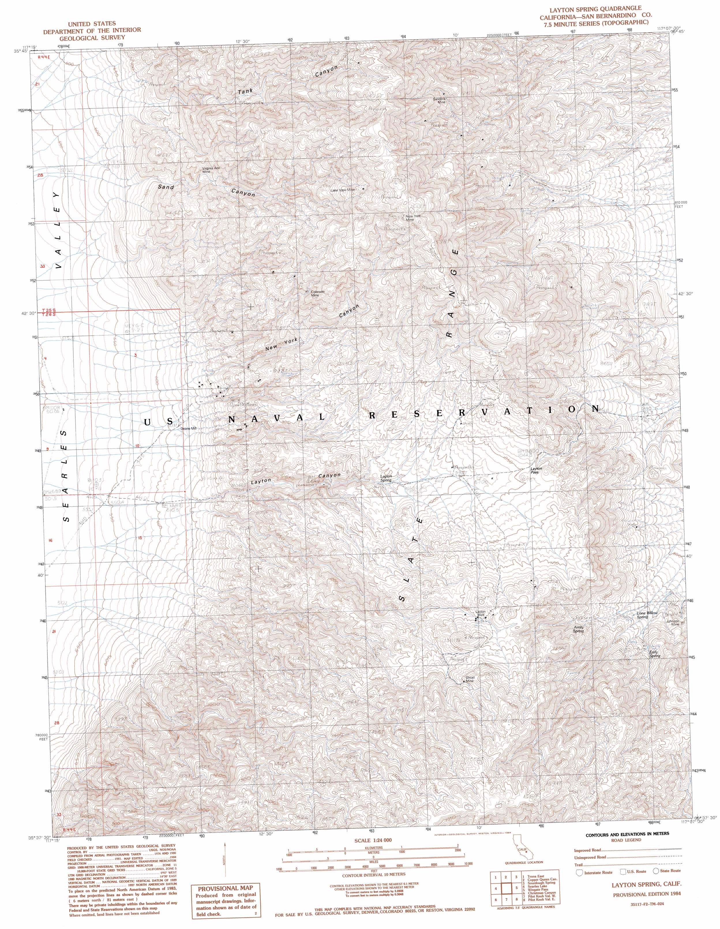
Layton Spring Topo Map California
To zoom in, hover over the map of Layton Spring
USGS Topo Quad 35117f2 - 1:24,000 scale
| Topo Map Name: | Layton Spring |
| USGS Topo Quad ID: | 35117f2 |
| Print Size: | ca. 21 1/4" wide x 27" high |
| Southeast Coordinates: | 35.625° N latitude / 117.125° W longitude |
| Map Center Coordinates: | 35.6875° N latitude / 117.1875° W longitude |
| U.S. State: | CA |
| Filename: | o35117f2.jpg |
| Download Map JPG Image: | Layton Spring topo map 1:24,000 scale |
| Map Type: | Topographic |
| Topo Series: | 7.5´ |
| Map Scale: | 1:24,000 |
| Source of Map Images: | United States Geological Survey (USGS) |
| Alternate Map Versions: |
Layton Spring CA 1984, updated 1984 Download PDF Buy paper map Layton Spring CA 2012 Download PDF Buy paper map Layton Spring CA 2015 Download PDF Buy paper map |
1:24,000 Topo Quads surrounding Layton Spring
Homewood Canyon |
Slate Range Crossing |
Manly Fall |
Manly Peak |
Anvil Spring Canyon West |
Trona West |
Trona East |
Copper Queen Canyon |
Sourdough Spring |
Wingate Wash West |
Westend |
Searles Lake |
Layton Spring |
Wingate Pass |
Hidden Spring |
Spangler Hills East |
Christmas Canyon |
Pilot Knob Valley West |
Pilot Knob Valley East |
West Of Leach Spring |
West Of Black Hills |
Black Hills |
Pilot Knob |
Eagle Crags |
West Of Nelson Lake |
> Back to 35117e1 at 1:100,000 scale
> Back to 35116a1 at 1:250,000 scale
> Back to U.S. Topo Maps home
Layton Spring topo map: Gazetteer
Layton Spring: Gaps
Layton Pass elevation 1066m 3497′Layton Spring: Mines
Colorado Mine elevation 1108m 3635′Ghost Mine elevation 1312m 4304′
Johnson Mine elevation 907m 2975′
Lake View Mine elevation 1185m 3887′
New York Mine elevation 1464m 4803′
Sandora Mine elevation 1219m 3999′
Virginia Ann Mine elevation 880m 2887′
Layton Spring: Springs
Amity Spring elevation 1048m 3438′Early Spring elevation 986m 3234′
Layton Spring elevation 922m 3024′
Lone Willow Spring elevation 936m 3070′
Layton Spring: Valleys
Layton Canyon elevation 637m 2089′New York Canyon elevation 681m 2234′
Sand Canyon elevation 652m 2139′
Tank Canyon elevation 673m 2208′
Layton Spring: Wells
Layton Well elevation 1198m 3930′Layton Spring digital topo map on disk
Buy this Layton Spring topo map showing relief, roads, GPS coordinates and other geographical features, as a high-resolution digital map file on DVD:
Southern Sierra Nevada, California & Southern Nevada
Buy digital topo maps: Southern Sierra Nevada, California & Southern Nevada