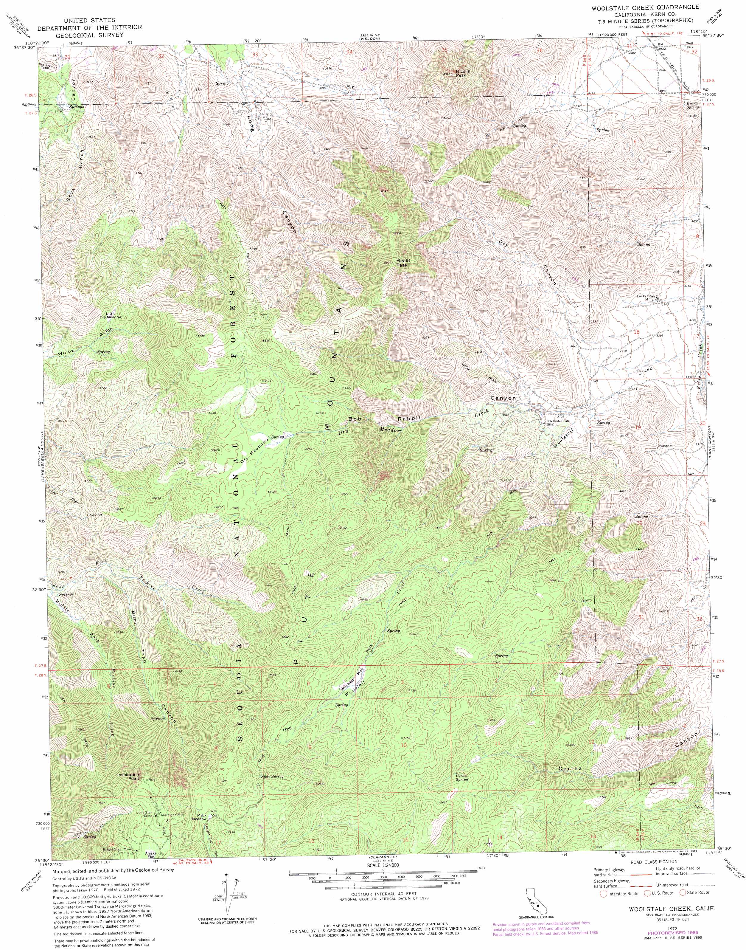
Woolstalf Creek Topo Map California
To zoom in, hover over the map of Woolstalf Creek
USGS Topo Quad 35118e3 - 1:24,000 scale
| Topo Map Name: | Woolstalf Creek |
| USGS Topo Quad ID: | 35118e3 |
| Print Size: | ca. 21 1/4" wide x 27" high |
| Southeast Coordinates: | 35.5° N latitude / 118.25° W longitude |
| Map Center Coordinates: | 35.5625° N latitude / 118.3125° W longitude |
| U.S. State: | CA |
| Filename: | o35118e3.jpg |
| Download Map JPG Image: | Woolstalf Creek topo map 1:24,000 scale |
| Map Type: | Topographic |
| Topo Series: | 7.5´ |
| Map Scale: | 1:24,000 |
| Source of Map Images: | United States Geological Survey (USGS) |
| Alternate Map Versions: |
Woolstalf Creek CA 1972, updated 1975 Download PDF Buy paper map Woolstalf Creek CA 1972, updated 1986 Download PDF Buy paper map Woolstalf Creek CA 2012 Download PDF Buy paper map Woolstalf Creek CA 2015 Download PDF Buy paper map |
| FStopo: | US Forest Service topo Woolstalf Creek is available: Download FStopo PDF Download FStopo TIF |
1:24,000 Topo Quads surrounding Woolstalf Creek
Tobias Peak |
Kernville |
Cannell Peak |
White Dome |
Lamont Peak |
Alta Sierra |
Lake Isabella North |
Weldon |
Onyx |
Walker Pass |
Miracle Hot Springs |
Lake Isabella South |
Woolstalf Creek |
Cane Canyon |
Horse Canyon |
Breckenridge Mountain |
Piute Peak |
Claraville |
Pinyon Mountain |
Dove Spring |
Oiler Peak |
Loraine |
Emerald Mountain |
Cross Mountain |
Cinco |
> Back to 35118e1 at 1:100,000 scale
> Back to 35118a1 at 1:250,000 scale
> Back to U.S. Topo Maps home
Woolstalf Creek topo map: Gazetteer
Woolstalf Creek: Flats
Dry Meadows elevation 1865m 6118′Little Dry Meadow elevation 1605m 5265′
Mack Meadow elevation 2205m 7234′
Woolstalf Meadow elevation 1979m 6492′
Woolstalf Creek: Mines
Bright Star Mine elevation 2313m 7588′Digger Pine Mine elevation 1227m 4025′
Lone Star Mine elevation 2358m 7736′
Lucky Box Mine elevation 989m 3244′
Woolstalf Creek: Populated Places
Moreland Mill elevation 2360m 7742′Woolstalf Creek: Springs
Brown Spring elevation 951m 3120′Cortez Spring elevation 1954m 6410′
Steve Spring elevation 2254m 7395′
Woolstalf Creek: Streams
Dry Meadow Creek elevation 1048m 3438′Woolstalf Creek elevation 955m 3133′
Woolstalf Creek: Summits
Heald Peak elevation 2079m 6820′Inspiration Point elevation 2385m 7824′
Nicolls Peak elevation 1844m 6049′
Woolstalf Creek: Valleys
Bear Trap Canyon elevation 1372m 4501′Bob Rabbit Canyon elevation 1050m 3444′
Dry Canyon elevation 1068m 3503′
Woolstalf Creek digital topo map on disk
Buy this Woolstalf Creek topo map showing relief, roads, GPS coordinates and other geographical features, as a high-resolution digital map file on DVD:
Southern Sierra Nevada, California & Southern Nevada
Buy digital topo maps: Southern Sierra Nevada, California & Southern Nevada