Lake Isabella South Topo Map California
To zoom in, hover over the map of Lake Isabella South
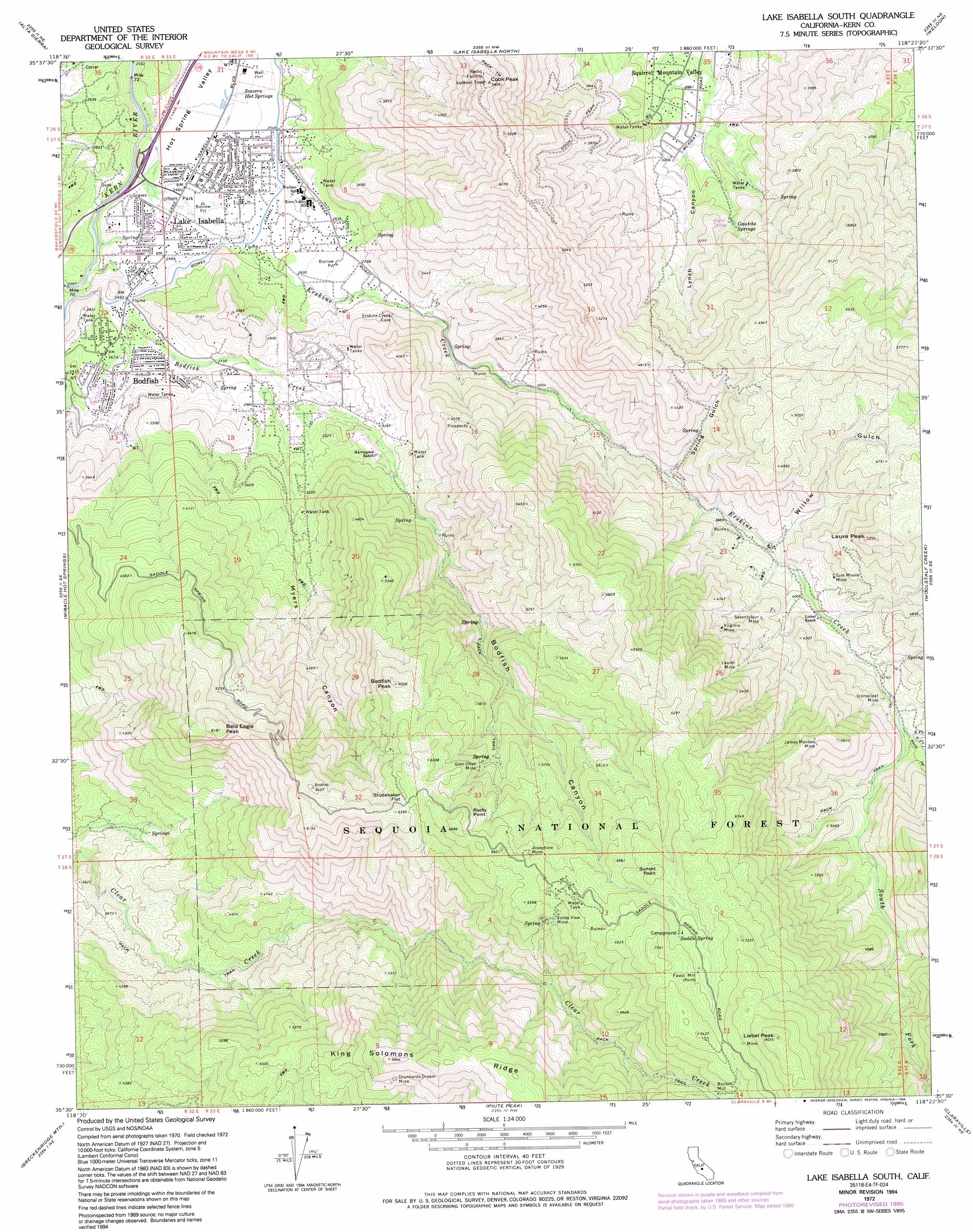
USGS Topo Quad 35118e4 - 1:24,000 scale
| Topo Map Name: | Lake Isabella South |
| USGS Topo Quad ID: | 35118e4 |
| Print Size: | ca. 21 1/4" wide x 27" high |
| Southeast Coordinates: | 35.5° N latitude / 118.375° W longitude |
| Map Center Coordinates: | 35.5625° N latitude / 118.4375° W longitude |
| U.S. State: | CA |
| Filename: | o35118e4.jpg |
| Download Map JPG Image: | Lake Isabella South topo map 1:24,000 scale |
| Map Type: | Topographic |
| Topo Series: | 7.5´ |
| Map Scale: | 1:24,000 |
| Source of Map Images: | United States Geological Survey (USGS) |
| Alternate Map Versions: |
Lake Isabella South CA 1972, updated 1975 Download PDF Buy paper map Lake Isabella South CA 1972, updated 1986 Download PDF Buy paper map Lake Isabella South CA 1972, updated 1994 Download PDF Buy paper map Lake Isabella South CA 2012 Download PDF Buy paper map Lake Isabella South CA 2015 Download PDF Buy paper map |
| FStopo: | US Forest Service topo Lake Isabella South is available: Download FStopo PDF Download FStopo TIF |
1:24,000 Topo Quads surrounding Lake Isabella South
Posey |
Tobias Peak |
Kernville |
Cannell Peak |
White Dome |
Glennville |
Alta Sierra |
Lake Isabella North |
Weldon |
Onyx |
Democrat Hot Springs |
Miracle Hot Springs |
Lake Isabella South |
Woolstalf Creek |
Cane Canyon |
Mount Adelaide |
Breckenridge Mountain |
Piute Peak |
Claraville |
Pinyon Mountain |
Bena |
Oiler Peak |
Loraine |
Emerald Mountain |
Cross Mountain |
> Back to 35118e1 at 1:100,000 scale
> Back to 35118a1 at 1:250,000 scale
> Back to U.S. Topo Maps home
Lake Isabella South topo map: Gazetteer
Lake Isabella South: Canals
Borel Canal elevation 773m 2536′Lake Isabella South: Capes
Rocky Point elevation 1866m 6122′Lake Isabella South: Flats
Studebaker Flat elevation 1891m 6204′Lake Isabella South: Mines
Devils Hole Mine elevation 1780m 5839′Devils Hole North Prospect elevation 1651m 5416′
Devils Hole South Prospect elevation 1844m 6049′
Drunkards Dream Mine elevation 1952m 6404′
Faust Mine elevation 2099m 6886′
Glen Olive Mine elevation 1803m 5915′
Heavens Delight Mine elevation 1438m 4717′
Iconoclast Mine elevation 1304m 4278′
James Morden Mine elevation 1641m 5383′
Jeanette Grant Mine elevation 1600m 5249′
Josephine Mine elevation 1977m 6486′
Laurel Mine elevation 1467m 4812′
Opportunity SubSection Number 4 Prospect elevation 1763m 5784′
Rocky Hill Prospect elevation 1542m 5059′
Seventyfour Mine elevation 1313m 4307′
Tom Moore Mine elevation 1267m 4156′
Tripoli Prospect elevation 1595m 5232′
Valley View Mine elevation 1870m 6135′
Virginia Mine elevation 1401m 4596′
White Rock Mine elevation 831m 2726′
Lake Isabella South: Parks
Uffert Park elevation 749m 2457′Lake Isabella South: Populated Places
Bodfish elevation 819m 2687′Burton Mill elevation 2049m 6722′
Lake Isabella elevation 766m 2513′
Scovern Hot Springs (historical) elevation 759m 2490′
Squirrel Mountain Valley elevation 884m 2900′
Lake Isabella South: Springs
Gautche Springs elevation 1092m 3582′Saddle Spring elevation 2100m 6889′
Scovern Hot Springs elevation 758m 2486′
Lake Isabella South: Streams
Bodfish Creek elevation 721m 2365′East Fork Erskine Creek elevation 1324m 4343′
Erskine Creek elevation 726m 2381′
Middle Fork Erskine Creek elevation 1324m 4343′
South Fork Erskine Creek elevation 1310m 4297′
Lake Isabella South: Summits
Bald Eagle Peak elevation 1882m 6174′Bodfish Peak elevation 1829m 6000′
Cook Peak elevation 1575m 5167′
Laura Peak elevation 1586m 5203′
Liebel Peak elevation 2441m 8008′
Sunset Point elevation 2099m 6886′
Lake Isabella South: Valleys
Bodfish Canyon elevation 918m 3011′Hot Spring Valley elevation 721m 2365′
Lynch Canyon elevation 954m 3129′
Myers Canyon elevation 868m 2847′
Spring Gulch elevation 1061m 3480′
Willow Gulch elevation 1153m 3782′
Lake Isabella South digital topo map on disk
Buy this Lake Isabella South topo map showing relief, roads, GPS coordinates and other geographical features, as a high-resolution digital map file on DVD:
Southern Sierra Nevada, California & Southern Nevada
Buy digital topo maps: Southern Sierra Nevada, California & Southern Nevada