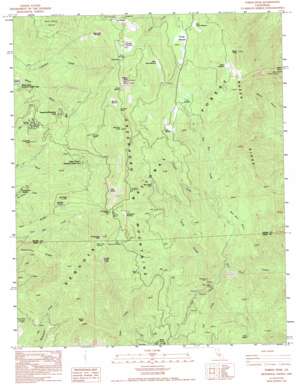
Tobias Peak Topo Map California
To zoom in, hover over the map of Tobias Peak
USGS Topo Quad 35118g5 - 1:24,000 scale
| Topo Map Name: | Tobias Peak |
| USGS Topo Quad ID: | 35118g5 |
| Print Size: | ca. 21 1/4" wide x 27" high |
| Southeast Coordinates: | 35.75° N latitude / 118.5° W longitude |
| Map Center Coordinates: | 35.8125° N latitude / 118.5625° W longitude |
| U.S. State: | CA |
| Filename: | o35118g5.jpg |
| Download Map JPG Image: | Tobias Peak topo map 1:24,000 scale |
| Map Type: | Topographic |
| Topo Series: | 7.5´ |
| Map Scale: | 1:24,000 |
| Source of Map Images: | United States Geological Survey (USGS) |
| Alternate Map Versions: |
Tobias Peak CA 1986, updated 1987 Download PDF Buy paper map Tobias Peak CA 1986, updated 1994 Download PDF Buy paper map Tobias Peak CA 2012 Download PDF Buy paper map Tobias Peak CA 2015 Download PDF Buy paper map |
| FStopo: | US Forest Service topo Tobias Peak is available: Download FStopo PDF Download FStopo TIF |
1:24,000 Topo Quads surrounding Tobias Peak
> Back to 35118e1 at 1:100,000 scale
> Back to 35118a1 at 1:250,000 scale
> Back to U.S. Topo Maps home
Tobias Peak topo map: Gazetteer
Tobias Peak: Areas
West Horse Meadow elevation 2217m 7273′Tobias Peak: Basins
Bull Run Basin elevation 1486m 4875′Tobias Peak: Flats
Baker Meadow elevation 2231m 7319′Berry Meadow elevation 2290m 7513′
Bull Run Meadow elevation 2209m 7247′
Dead Horse Meadow elevation 2233m 7326′
Dry Meadow elevation 1967m 6453′
Dunlap Meadow elevation 2020m 6627′
East Horse Meadow elevation 1995m 6545′
Frog Meadow elevation 2299m 7542′
Horse Meadow elevation 2035m 6676′
Marshall Meadow elevation 1984m 6509′
O'Quinn Meadow elevation 1415m 4642′
Poison Meadow elevation 2334m 7657′
Portuguese Meadow elevation 2156m 7073′
Tiger Flat elevation 2025m 6643′
Tobias Meadow elevation 2285m 7496′
Tyler Meadow elevation 1966m 6450′
Tobias Peak: Gaps
Bull Run Pass elevation 2302m 7552′Fir Camp Saddle elevation 2117m 6945′
Portuguese Pass elevation 2241m 7352′
Tobias Peak: Mines
Betty Lou Mine elevation 1563m 5127′Black Sambo Mine elevation 1627m 5337′
Owl Mine elevation 1772m 5813′
Silver Strand Mine elevation 1537m 5042′
Tip Top Mine elevation 2197m 7208′
Tobias Peak: Populated Places
Guernsey Mill elevation 1660m 5446′Spear Creek Summer Home Tract elevation 1803m 5915′
Sugarloaf Mountain Park elevation 1797m 5895′
Tobias Peak: Ranges
Greenhorn Mountains elevation 2523m 8277′Tobias Peak: Ridges
Baker Ridge elevation 2043m 6702′Peel Ridge elevation 1761m 5777′
Tobias Peak: Springs
Cane Spring elevation 1900m 6233′Cold Spring elevation 2110m 6922′
Spout Spring elevation 1783m 5849′
Water Gap Spring elevation 2343m 7687′
Tobias Peak: Streams
Calf Creek elevation 1411m 4629′Cow Creek elevation 1531m 5022′
Deep Creek elevation 1437m 4714′
Schultz Creek elevation 1559m 5114′
Tobias Peak: Summits
Baker Peak elevation 2392m 7847′Baker Point elevation 2360m 7742′
Bohna Peak elevation 2044m 6706′
Bull Run Peak elevation 2444m 8018′
Peel Peak elevation 2061m 6761′
Portuguese Peak elevation 2365m 7759′
Sugarloaf Peak elevation 1870m 6135′
Sunday Peak elevation 2501m 8205′
Tobias Peak elevation 2523m 8277′
Tobias Peak: Trails
Bull Run Cattle Drive elevation 2061m 6761′Tobias Trail elevation 2143m 7030′
Virginia Trail elevation 2019m 6624′
Tobias Peak: Woods
Deer Creek Grove elevation 1801m 5908′Tobias Peak digital topo map on disk
Buy this Tobias Peak topo map showing relief, roads, GPS coordinates and other geographical features, as a high-resolution digital map file on DVD:
Southern Sierra Nevada, California & Southern Nevada
Buy digital topo maps: Southern Sierra Nevada, California & Southern Nevada


