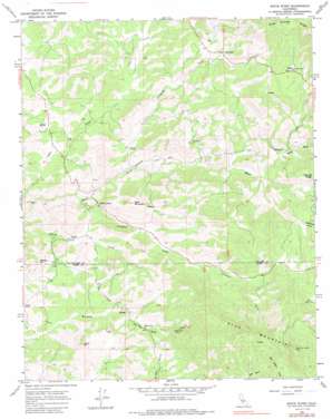
White River Topo Map California
To zoom in, hover over the map of White River
USGS Topo Quad 35118g7 - 1:24,000 scale
| Topo Map Name: | White River |
| USGS Topo Quad ID: | 35118g7 |
| Print Size: | ca. 21 1/4" wide x 27" high |
| Southeast Coordinates: | 35.75° N latitude / 118.75° W longitude |
| Map Center Coordinates: | 35.8125° N latitude / 118.8125° W longitude |
| U.S. State: | CA |
| Filename: | o35118g7.jpg |
| Download Map JPG Image: | White River topo map 1:24,000 scale |
| Map Type: | Topographic |
| Topo Series: | 7.5´ |
| Map Scale: | 1:24,000 |
| Source of Map Images: | United States Geological Survey (USGS) |
| Alternate Map Versions: |
White River CA 1965, updated 1966 Download PDF Buy paper map White River CA 1965, updated 1985 Download PDF Buy paper map White River CA 2012 Download PDF Buy paper map White River CA 2015 Download PDF Buy paper map |
1:24,000 Topo Quads surrounding White River
> Back to 35118e1 at 1:100,000 scale
> Back to 35118a1 at 1:250,000 scale
> Back to U.S. Topo Maps home
White River topo map: Gazetteer
White River: Mines
Blue Mountain Mine elevation 784m 2572′Last Chance Mine elevation 288m 944′
White River: Populated Places
White River elevation 341m 1118′White River: Ridges
Blue Mountain elevation 1457m 4780′White River: Streams
Arrastre Creek elevation 316m 1036′Chalaney Creek elevation 342m 1122′
White River: Summits
Bald Mountain elevation 726m 2381′Eclipse Hill elevation 587m 1925′
Isham Hill elevation 668m 2191′
White River: Valleys
Joe Bowen Canyon elevation 766m 2513′White River digital topo map on disk
Buy this White River topo map showing relief, roads, GPS coordinates and other geographical features, as a high-resolution digital map file on DVD:
Southern Sierra Nevada, California & Southern Nevada
Buy digital topo maps: Southern Sierra Nevada, California & Southern Nevada


