Mckittrick Summit Topo Map California
To zoom in, hover over the map of Mckittrick Summit
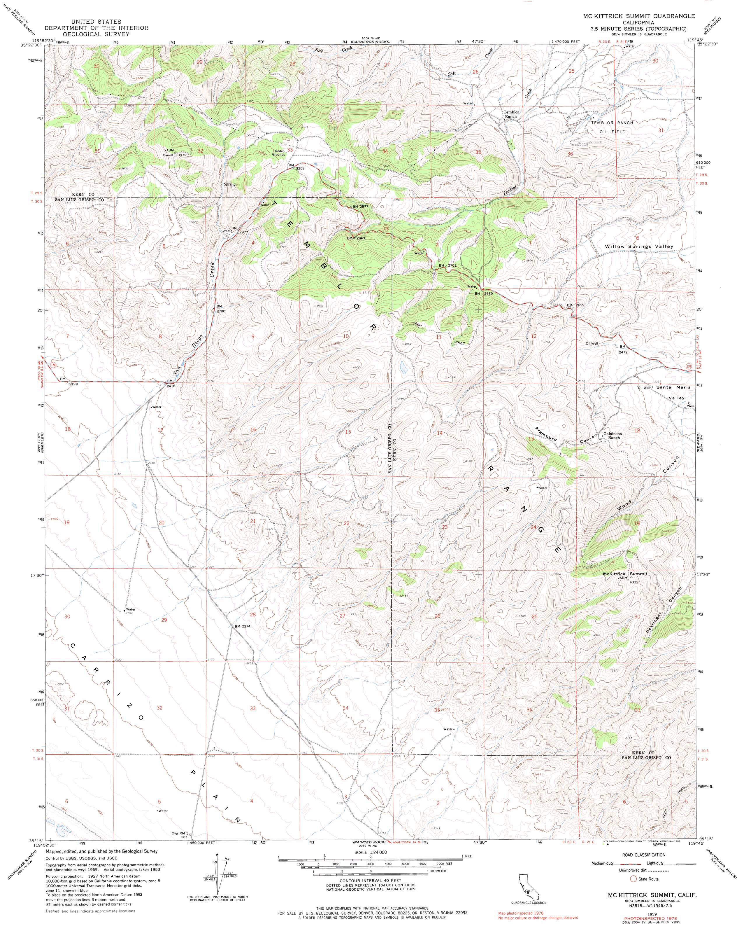
USGS Topo Quad 35119c7 - 1:24,000 scale
| Topo Map Name: | Mckittrick Summit |
| USGS Topo Quad ID: | 35119c7 |
| Print Size: | ca. 21 1/4" wide x 27" high |
| Southeast Coordinates: | 35.25° N latitude / 119.75° W longitude |
| Map Center Coordinates: | 35.3125° N latitude / 119.8125° W longitude |
| U.S. State: | CA |
| Filename: | o35119c7.jpg |
| Download Map JPG Image: | Mckittrick Summit topo map 1:24,000 scale |
| Map Type: | Topographic |
| Topo Series: | 7.5´ |
| Map Scale: | 1:24,000 |
| Source of Map Images: | United States Geological Survey (USGS) |
| Alternate Map Versions: |
Mc Kittrick Summit CA 1959, updated 1961 Download PDF Buy paper map Mc Kittrick Summit CA 1959, updated 1970 Download PDF Buy paper map Mc Kittrick Summit CA 1959, updated 1983 Download PDF Buy paper map McKittrick Summit CA 2012 Download PDF Buy paper map McKittrick Summit CA 2015 Download PDF Buy paper map |
1:24,000 Topo Quads surrounding Mckittrick Summit
Packwood Creek |
Shale Point |
Blackwells Corner |
Lost Hills |
Semitropic |
La Panza Ne |
Las Yeguas Ranch |
Carneros Rocks |
Belridge |
Lokern |
California Valley |
Simmler |
Mckittrick Summit |
Reward |
West Elk Hills |
Branch Mountain |
Chimineas Ranch |
Painted Rock |
Panorama Hills |
Fellows |
Miranda Pine Mountain |
Taylor Canyon |
Caliente Mountain |
Wells Ranch |
Elkhorn Hills |
> Back to 35119a1 at 1:100,000 scale
> Back to 35118a1 at 1:250,000 scale
> Back to U.S. Topo Maps home
Mckittrick Summit topo map: Gazetteer
Mckittrick Summit: Oilfields
Temblor Ranch Oil Field elevation 460m 1509′Mckittrick Summit: Ranges
Temblor Range elevation 1176m 3858′Mckittrick Summit: Streams
San Diego Creek elevation 659m 2162′Mckittrick Summit: Summits
McKittrick Summit elevation 1318m 4324′Mckittrick Summit: Valleys
Aramburu Canyon elevation 843m 2765′Mckittrick Summit digital topo map on disk
Buy this Mckittrick Summit topo map showing relief, roads, GPS coordinates and other geographical features, as a high-resolution digital map file on DVD:
Southern Sierra Nevada, California & Southern Nevada
Buy digital topo maps: Southern Sierra Nevada, California & Southern Nevada