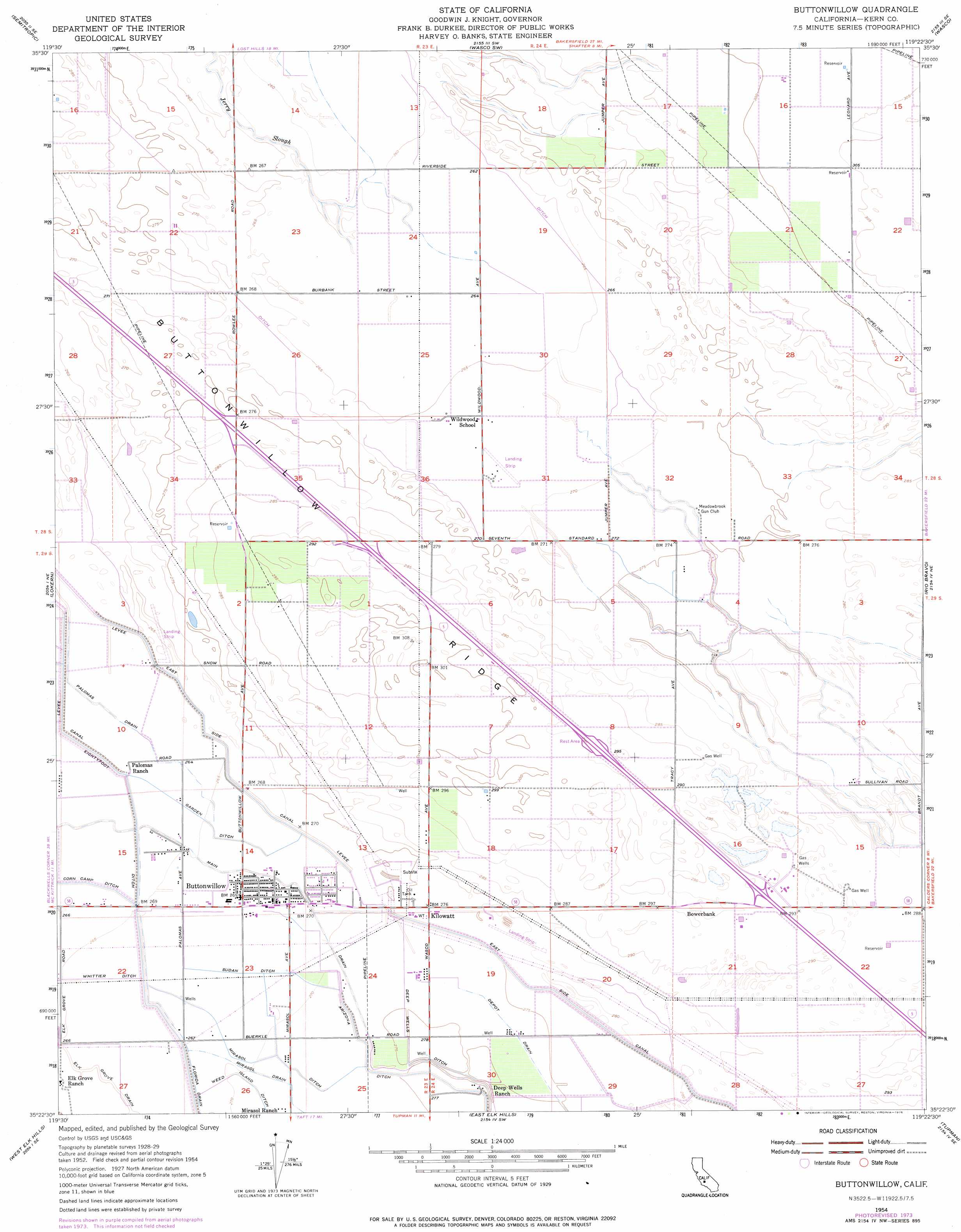
Buttonwillow Topo Map California
To zoom in, hover over the map of Buttonwillow
USGS Topo Quad 35119d4 - 1:24,000 scale
| Topo Map Name: | Buttonwillow |
| USGS Topo Quad ID: | 35119d4 |
| Print Size: | ca. 21 1/4" wide x 27" high |
| Southeast Coordinates: | 35.375° N latitude / 119.375° W longitude |
| Map Center Coordinates: | 35.4375° N latitude / 119.4375° W longitude |
| U.S. State: | CA |
| Filename: | o35119d4.jpg |
| Download Map JPG Image: | Buttonwillow topo map 1:24,000 scale |
| Map Type: | Topographic |
| Topo Series: | 7.5´ |
| Map Scale: | 1:24,000 |
| Source of Map Images: | United States Geological Survey (USGS) |
| Alternate Map Versions: |
Buttonwillow CA 1954, updated 1956 Download PDF Buy paper map Buttonwillow CA 1954, updated 1976 Download PDF Buy paper map Buttonwillow CA 1954, updated 1976 Download PDF Buy paper map Buttonwillow CA 2012 Download PDF Buy paper map Buttonwillow CA 2015 Download PDF Buy paper map |
1:24,000 Topo Quads surrounding Buttonwillow
Lost Hills Nw |
Lost Hills Ne |
Wasco Nw |
Pond |
Mcfarland |
Lost Hills |
Semitropic |
Wasco Sw |
Wasco |
Famoso |
Belridge |
Lokern |
Buttonwillow |
Rio Bravo |
Rosedale |
Reward |
West Elk Hills |
East Elk Hills |
Tupman |
Stevens |
Panorama Hills |
Fellows |
Taft |
Buena Vista Lakebed |
Millux |
> Back to 35119a1 at 1:100,000 scale
> Back to 35118a1 at 1:250,000 scale
> Back to U.S. Topo Maps home
Buttonwillow topo map: Gazetteer
Buttonwillow: Canals
Depot Drain elevation 85m 278′East Side Canal elevation 83m 272′
Eightyfoot Ditch elevation 81m 265′
Elk Grove Drain elevation 82m 269′
Garden Ditch elevation 82m 269′
Mirasol Ditch elevation 83m 272′
Sudan Ditch elevation 82m 269′
Whittier Ditch elevation 82m 269′
Buttonwillow: Parks
Buttonwillow Park elevation 83m 272′Buttonwillow: Populated Places
Bowerbank elevation 91m 298′Buttonwillow elevation 82m 269′
Kilowatt elevation 85m 278′
Buttonwillow: Post Offices
Buttonwillow Post Office elevation 82m 269′Buttonwillow digital topo map on disk
Buy this Buttonwillow topo map showing relief, roads, GPS coordinates and other geographical features, as a high-resolution digital map file on DVD:
Southern Sierra Nevada, California & Southern Nevada
Buy digital topo maps: Southern Sierra Nevada, California & Southern Nevada