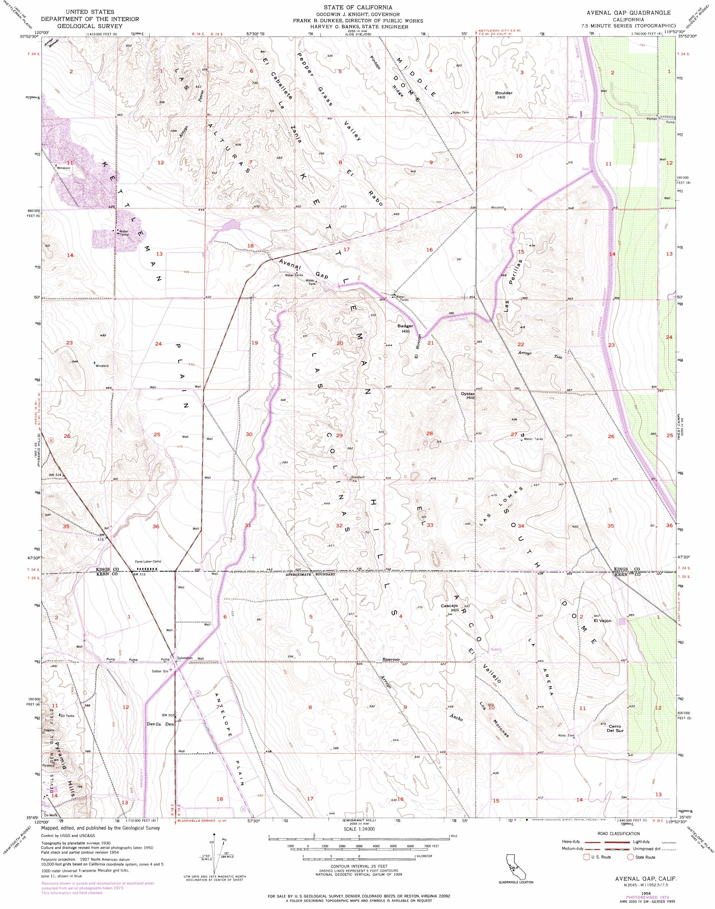
Avenal Gap Topo Map California
To zoom in, hover over the map of Avenal Gap
USGS Topo Quad 35119g8 - 1:24,000 scale
| Topo Map Name: | Avenal Gap |
| USGS Topo Quad ID: | 35119g8 |
| Print Size: | ca. 21 1/4" wide x 27" high |
| Southeast Coordinates: | 35.75° N latitude / 119.875° W longitude |
| Map Center Coordinates: | 35.8125° N latitude / 119.9375° W longitude |
| U.S. State: | CA |
| Filename: | o35119g8.jpg |
| Download Map JPG Image: | Avenal Gap topo map 1:24,000 scale |
| Map Type: | Topographic |
| Topo Series: | 7.5´ |
| Map Scale: | 1:24,000 |
| Source of Map Images: | United States Geological Survey (USGS) |
| Alternate Map Versions: |
Avenal Gap CA 1950 Download PDF Buy paper map Avenal Gap CA 1954, updated 1956 Download PDF Buy paper map Avenal Gap CA 1954, updated 1976 Download PDF Buy paper map Avenal Gap CA 1954, updated 1976 Download PDF Buy paper map Avenal Gap CA 2012 Download PDF Buy paper map Avenal Gap CA 2015 Download PDF Buy paper map |
1:24,000 Topo Quads surrounding Avenal Gap
Avenal |
La Cima |
Kettleman City |
Stratford Se |
El Rico Ranch |
Garza Peak |
Kettleman Plain |
Los Viejos |
Dudley Ridge |
Hacienda Ranch Nw |
Tent Hills |
Pyramid Hills |
Avenal Gap |
West Camp |
Lone Tree Well |
Orchard Peak |
Sawtooth Ridge |
Emigrant Hill |
Antelope Plain |
Lost Hills Nw |
Holland Canyon |
Packwood Creek |
Shale Point |
Blackwells Corner |
Lost Hills |
> Back to 35119e1 at 1:100,000 scale
> Back to 35118a1 at 1:250,000 scale
> Back to U.S. Topo Maps home
Avenal Gap topo map: Gazetteer
Avenal Gap: Flats
El Rincón elevation 114m 374′La Arena elevation 143m 469′
Avenal Gap: Gaps
Avenal Gap elevation 118m 387′Avenal Gap: Post Offices
Devils Den Post Office (historical) elevation 154m 505′Avenal Gap: Ranges
Las Colinas elevation 216m 708′Las Lomas elevation 151m 495′
Avenal Gap: Ridges
El Arco elevation 155m 508′Las Perillas elevation 139m 456′
Los Morones elevation 143m 469′
Pintojo Ridge elevation 176m 577′
South Dome elevation 144m 472′
Avenal Gap: Springs
Alamo Solo Spring elevation 167m 547′Avenal Gap: Streams
Arroyo Ancho elevation 140m 459′Arroyo Petreo elevation 143m 469′
Arroyo Tozo elevation 96m 314′
Avenal Gap: Summits
Badger Hill elevation 140m 459′Boulder Hill elevation 146m 479′
Cascajo Hill elevation 178m 583′
Cerro del Sur elevation 146m 479′
El Rabo elevation 130m 426′
El Vejón elevation 166m 544′
Oyster Hill elevation 146m 479′
Avenal Gap: Valleys
El Vallejo elevation 124m 406′La Zanja elevation 146m 479′
Pepper Grass Valley elevation 105m 344′
Avenal Gap digital topo map on disk
Buy this Avenal Gap topo map showing relief, roads, GPS coordinates and other geographical features, as a high-resolution digital map file on DVD:
Southern Sierra Nevada, California & Southern Nevada
Buy digital topo maps: Southern Sierra Nevada, California & Southern Nevada