Branch Mountain Topo Map California
To zoom in, hover over the map of Branch Mountain
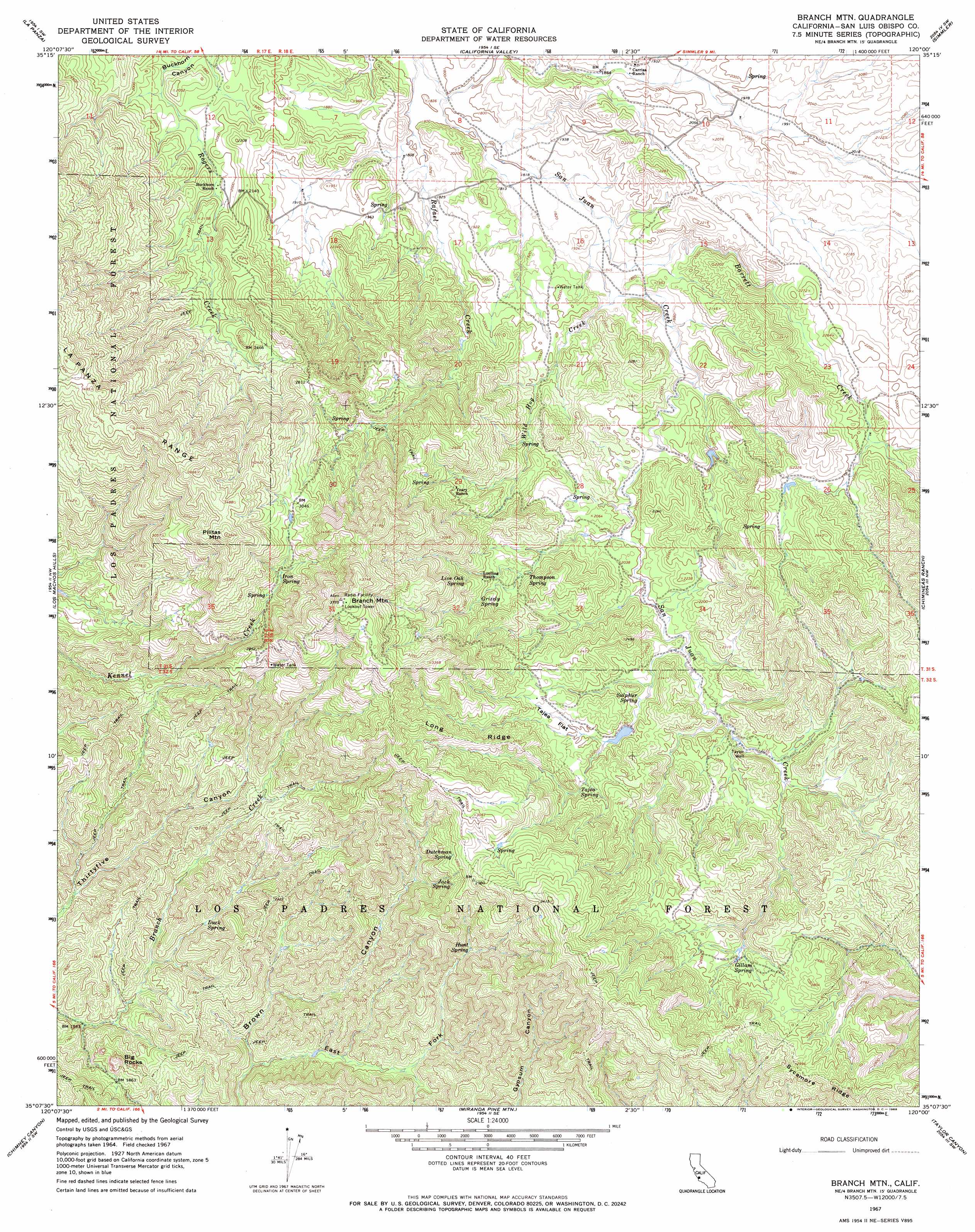
USGS Topo Quad 35120b1 - 1:24,000 scale
| Topo Map Name: | Branch Mountain |
| USGS Topo Quad ID: | 35120b1 |
| Print Size: | ca. 21 1/4" wide x 27" high |
| Southeast Coordinates: | 35.125° N latitude / 120° W longitude |
| Map Center Coordinates: | 35.1875° N latitude / 120.0625° W longitude |
| U.S. State: | CA |
| Filename: | o35120b1.jpg |
| Download Map JPG Image: | Branch Mountain topo map 1:24,000 scale |
| Map Type: | Topographic |
| Topo Series: | 7.5´ |
| Map Scale: | 1:24,000 |
| Source of Map Images: | United States Geological Survey (USGS) |
| Alternate Map Versions: |
Branch Mtn CA 1967, updated 1968 Download PDF Buy paper map Branch Mtn CA 1967, updated 1968 Download PDF Buy paper map Branch Mountain CA 1995, updated 2000 Download PDF Buy paper map Branch Mountain CA 2012 Download PDF Buy paper map Branch Mountain CA 2015 Download PDF Buy paper map |
| FStopo: | US Forest Service topo Branch Mountain is available: Download FStopo PDF Download FStopo TIF |
1:24,000 Topo Quads surrounding Branch Mountain
Camatta Ranch |
La Panza Ranch |
La Panza Ne |
Las Yeguas Ranch |
Carneros Rocks |
Pozo Summit |
La Panza |
California Valley |
Simmler |
Mckittrick Summit |
Caldwell Mesa |
Los Machos Hills |
Branch Mountain |
Chimineas Ranch |
Painted Rock |
Huasna Peak |
Chimney Canyon |
Miranda Pine Mountain |
Taylor Canyon |
Caliente Mountain |
Twitchell Dam |
Tepusquet Canyon |
Manzanita Mountain |
Bates Canyon |
Peak Mountain |
> Back to 35120a1 at 1:100,000 scale
> Back to 35120a1 at 1:250,000 scale
> Back to U.S. Topo Maps home
Branch Mountain topo map: Gazetteer
Branch Mountain: Flats
Tajea Flat elevation 679m 2227′Branch Mountain: Pillars
Big Rocks elevation 651m 2135′Branch Mountain: Ridges
Long Ridge elevation 830m 2723′Branch Mountain: Springs
Buck Spring elevation 557m 1827′Dutchman Spring elevation 846m 2775′
Gillam Spring elevation 757m 2483′
Grizzly Spring elevation 750m 2460′
Hunt Spring elevation 690m 2263′
Iron Spring elevation 842m 2762′
Jack Spring elevation 695m 2280′
Live Oak Spring elevation 789m 2588′
Sulphur Spring elevation 641m 2103′
Tajea Spring elevation 695m 2280′
Thompson Spring elevation 666m 2185′
Branch Mountain: Streams
Barrett Creek elevation 565m 1853′Wild Hog Creek elevation 565m 1853′
Branch Mountain: Summits
Branch Mountain elevation 1142m 3746′Pilitas Mountain elevation 1098m 3602′
Branch Mountain: Valleys
East Fork Brown Canyon elevation 475m 1558′Branch Mountain: Wells
Taylor Well elevation 646m 2119′Branch Mountain digital topo map on disk
Buy this Branch Mountain topo map showing relief, roads, GPS coordinates and other geographical features, as a high-resolution digital map file on DVD: