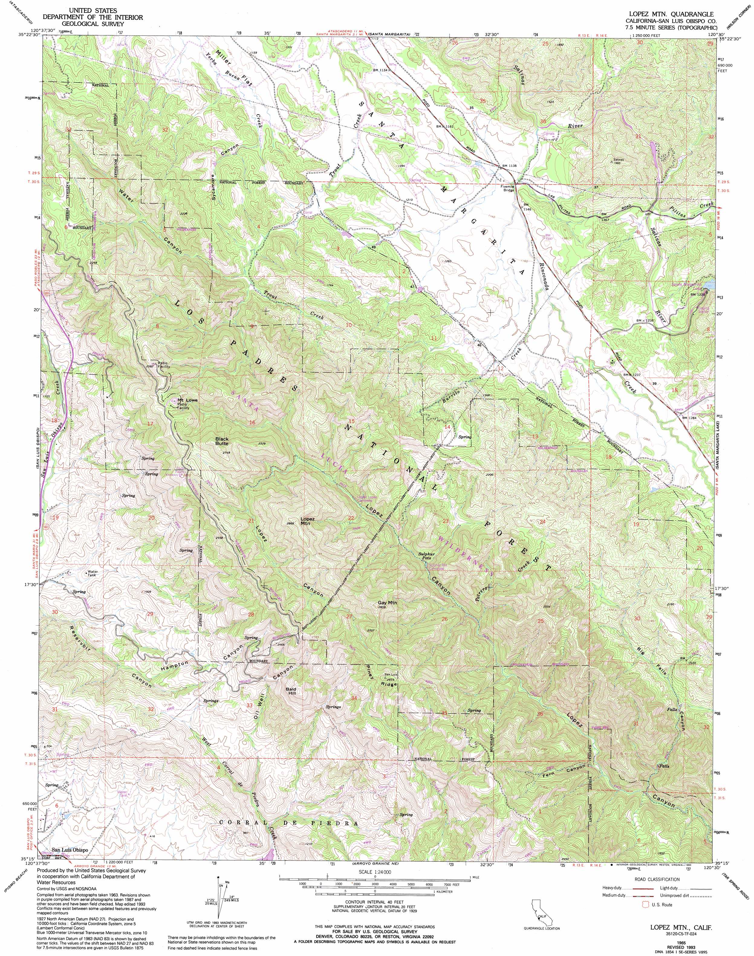
Lopez Mountain Topo Map California
To zoom in, hover over the map of Lopez Mountain
USGS Topo Quad 35120c5 - 1:24,000 scale
| Topo Map Name: | Lopez Mountain |
| USGS Topo Quad ID: | 35120c5 |
| Print Size: | ca. 21 1/4" wide x 27" high |
| Southeast Coordinates: | 35.25° N latitude / 120.5° W longitude |
| Map Center Coordinates: | 35.3125° N latitude / 120.5625° W longitude |
| U.S. State: | CA |
| Filename: | o35120c5.jpg |
| Download Map JPG Image: | Lopez Mountain topo map 1:24,000 scale |
| Map Type: | Topographic |
| Topo Series: | 7.5´ |
| Map Scale: | 1:24,000 |
| Source of Map Images: | United States Geological Survey (USGS) |
| Alternate Map Versions: |
Lopez Mountain CA 1965, updated 1966 Download PDF Buy paper map Lopez Mountain CA 1965, updated 1974 Download PDF Buy paper map Lopez Mountain CA 1965, updated 1986 Download PDF Buy paper map Lopez Mountain CA 1965, updated 1993 Download PDF Buy paper map Lopez Mountain CA 1995, updated 2000 Download PDF Buy paper map Lopez Mountain CA 2012 Download PDF Buy paper map Lopez Mountain CA 2015 Download PDF Buy paper map |
| FStopo: | US Forest Service topo Lopez Mountain is available: Download FStopo PDF Download FStopo TIF |
1:24,000 Topo Quads surrounding Lopez Mountain
York Mountain |
Templeton |
Creston |
Shedd Canyon |
Camatta Canyon |
Morro Bay North |
Atascadero |
Santa Margarita |
Wilson Corner |
Camatta Ranch |
Morro Bay South |
San Luis Obispo |
Lopez Mountain |
Santa Margarita Lake |
Pozo Summit |
Port San Luis |
Pismo Beach |
Arroyo Grande Ne |
Tar Spring Ridge |
Caldwell Mesa |
Oceano |
Nipomo |
Huasna Peak |
> Back to 35120a1 at 1:100,000 scale
> Back to 35120a1 at 1:250,000 scale
> Back to U.S. Topo Maps home
Lopez Mountain topo map: Gazetteer
Lopez Mountain: Bridges
Fivemile Bridge elevation 342m 1122′Lopez Mountain: Dams
Salinas Dam elevation 390m 1279′Lopez Mountain: Flats
Miller Flat elevation 345m 1131′Lopez Mountain: Reservoirs
Santa Margarita Lake elevation 397m 1302′Lopez Mountain: Ridges
Piney Ridge elevation 867m 2844′Lopez Mountain: Springs
Sulphur Pots elevation 376m 1233′Lopez Mountain: Streams
Burrito Creek elevation 354m 1161′Pilitas Creek elevation 351m 1151′
Potrero Creek elevation 363m 1190′
Rinconada Creek elevation 337m 1105′
Lopez Mountain: Summits
Bald Hill elevation 711m 2332′Black Butte elevation 824m 2703′
Gay Mountain elevation 850m 2788′
Lopez Mountain elevation 869m 2851′
Mount Lowe elevation 771m 2529′
Lopez Mountain: Valleys
Big Falls Canyon elevation 245m 803′Fern Canyon elevation 267m 875′
Hampton Canyon elevation 255m 836′
Oil Well Canyon elevation 228m 748′
Sycamore Canyon elevation 354m 1161′
Water Canyon elevation 385m 1263′
Lopez Mountain digital topo map on disk
Buy this Lopez Mountain topo map showing relief, roads, GPS coordinates and other geographical features, as a high-resolution digital map file on DVD: