Pyramid Hills Topo Map California
To zoom in, hover over the map of Pyramid Hills
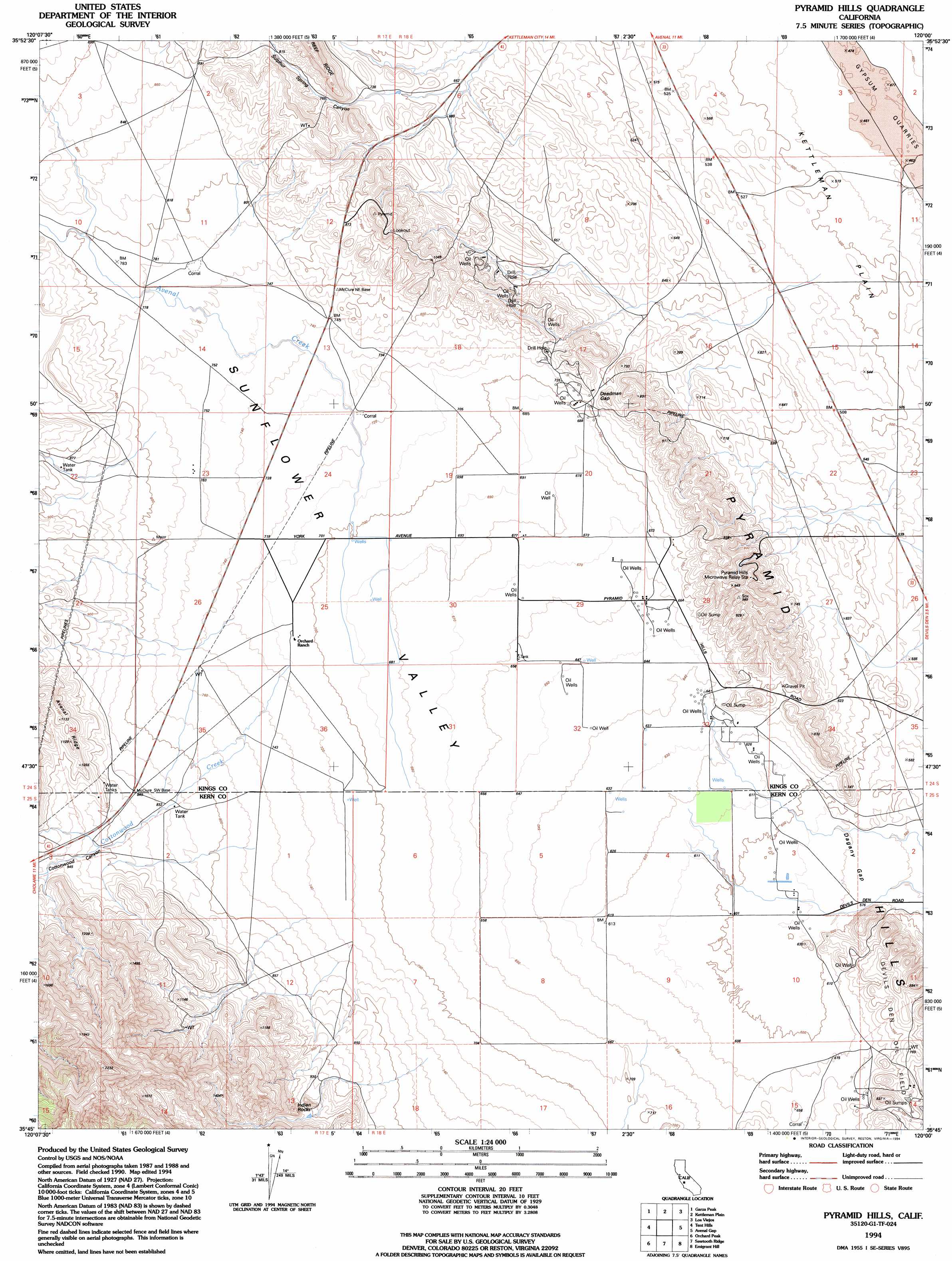
USGS Topo Quad 35120g1 - 1:24,000 scale
| Topo Map Name: | Pyramid Hills |
| USGS Topo Quad ID: | 35120g1 |
| Print Size: | ca. 21 1/4" wide x 27" high |
| Southeast Coordinates: | 35.75° N latitude / 120° W longitude |
| Map Center Coordinates: | 35.8125° N latitude / 120.0625° W longitude |
| U.S. State: | CA |
| Filename: | o35120g1.jpg |
| Download Map JPG Image: | Pyramid Hills topo map 1:24,000 scale |
| Map Type: | Topographic |
| Topo Series: | 7.5´ |
| Map Scale: | 1:24,000 |
| Source of Map Images: | United States Geological Survey (USGS) |
| Alternate Map Versions: |
Pyramid Hills CA 1953, updated 1956 Download PDF Buy paper map Pyramid Hills CA 1953, updated 1968 Download PDF Buy paper map Pyramid Hills CA 1953, updated 1976 Download PDF Buy paper map Pyramid Hills CA 1994, updated 1994 Download PDF Buy paper map Pyramid Hills CA 2012 Download PDF Buy paper map Pyramid Hills CA 2015 Download PDF Buy paper map |
1:24,000 Topo Quads surrounding Pyramid Hills
Kreyenhagen Hills |
Avenal |
La Cima |
Kettleman City |
Stratford Se |
The Dark Hole |
Garza Peak |
Kettleman Plain |
Los Viejos |
Dudley Ridge |
Cholame Valley |
Tent Hills |
Pyramid Hills |
Avenal Gap |
West Camp |
Cholame |
Orchard Peak |
Sawtooth Ridge |
Emigrant Hill |
Antelope Plain |
Camatta Canyon |
Holland Canyon |
Packwood Creek |
Shale Point |
Blackwells Corner |
> Back to 35120e1 at 1:100,000 scale
> Back to 35120a1 at 1:250,000 scale
> Back to U.S. Topo Maps home
Pyramid Hills topo map: Gazetteer
Pyramid Hills: Areas
Devil Den elevation 261m 856′Pyramid Hills: Basins
Sunflower Valley elevation 208m 682′Pyramid Hills: Gaps
Dagany Gap elevation 176m 577′Deadman Gap elevation 219m 718′
Pyramid Hills: Oilfields
Devils Den Oil Field elevation 219m 718′Pyramid Hills: Ranges
Pyramid Hills elevation 252m 826′Pyramid Hills: Streams
Arroyo Menudo elevation 145m 475′Avenal Creek elevation 212m 695′
Cottonwood Creek elevation 212m 695′
Pyramid Hills: Summits
Indian Rocks elevation 344m 1128′Pyramid Hills: Valleys
Cottonwood Canyon elevation 269m 882′Cottonwood Canyon elevation 274m 898′
Sulphur Spring Canyon elevation 203m 666′
Pyramid Hills digital topo map on disk
Buy this Pyramid Hills topo map showing relief, roads, GPS coordinates and other geographical features, as a high-resolution digital map file on DVD: