Kitty Hawk Topo Map North Carolina
To zoom in, hover over the map of Kitty Hawk
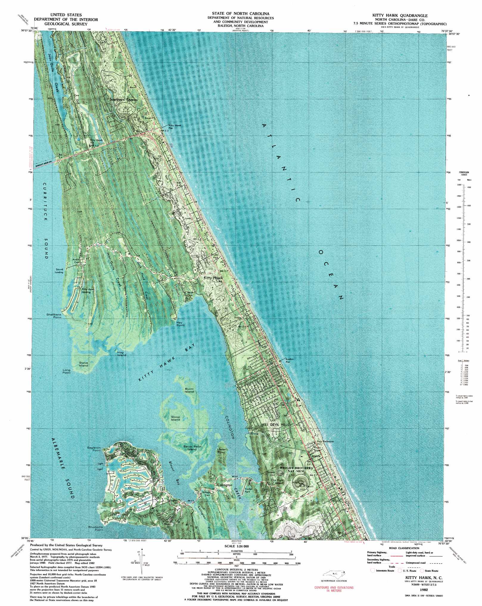
USGS Topo Quad 36075a6 - 1:24,000 scale
| Topo Map Name: | Kitty Hawk |
| USGS Topo Quad ID: | 36075a6 |
| Print Size: | ca. 21 1/4" wide x 27" high |
| Southeast Coordinates: | 36° N latitude / 75.625° W longitude |
| Map Center Coordinates: | 36.0625° N latitude / 75.6875° W longitude |
| U.S. State: | NC |
| Filename: | p36075a6.jpg |
| Download Map JPG Image: | Kitty Hawk topo map 1:24,000 scale |
| Map Type: | Orthophoto |
| Topo Series: | 7.5´ |
| Map Scale: | 1:24,000 |
| Source of Map Images: | United States Geological Survey (USGS) |
| Alternate Map Versions: |
Kitty Hawk NC 1982, updated 1983 Download PDF Buy paper map Kitty Hawk NC 2010 Download PDF Buy paper map Kitty Hawk NC 2013 Download PDF Buy paper map Kitty Hawk NC 2016 Download PDF Buy paper map |
1:24,000 Topo Quads surrounding Kitty Hawk
Coinjock |
Mossey Islands |
|||
Camden Point |
Jarvisburg |
Martin Point |
||
Point Harbor |
Kitty Hawk |
|||
East Lake |
Manns Harbor |
Manteo |
Roanoke Island Ne |
|
Buffalo City |
East Lake Se |
Wanchese |
Oregon Inlet |
> Back to 36075a1 at 1:100,000 scale
> Back to 36074a1 at 1:250,000 scale
> Back to U.S. Topo Maps home
Kitty Hawk topo map: Gazetteer
Kitty Hawk: Airports
First Flight Airport elevation 3m 9′Kitty Hawk: Bays
Baum Bay elevation 1m 3′Blount Bay elevation 0m 0′
Kitty Hawk Bay elevation 0m 0′
Tillets Cove elevation 0m 0′
Kitty Hawk: Capes
Eagleton Point elevation 0m 0′Hay Point elevation 0m 0′
Long Point elevation 0m 0′
Meter Point elevation 0m 0′
Rhodoms Point elevation 0m 0′
Shellbank Point elevation 0m 0′
Kitty Hawk: Guts
Colington Creek elevation 0m 0′Deep Ditch elevation 0m 0′
Kitty Hawk: Islands
Baum Point Island elevation 0m 0′Bum Point Island elevation 0m 0′
Burnt Island elevation 0m 0′
Colington Island elevation 2m 6′
Hog Island elevation 0m 0′
Sloop Island elevation 0m 0′
Stove Island elevation 1m 3′
Walker Island elevation 0m 0′
Kitty Hawk: Lakes
Colony Lake elevation 1m 3′Kitty Hawk: Parks
Wright Brothers National Memorial elevation 2m 6′Wright Brothers National Memorial Visitor Center elevation 3m 9′
Kitty Hawk: Populated Places
Avalon Bench elevation 2m 6′Colington elevation 1m 3′
Croatan Shores elevation 3m 9′
Eagleton elevation 2m 6′
Kill Devil Hills elevation 2m 6′
Kitty Hawk elevation 2m 6′
Kitty Hawk Beach elevation 0m 0′
Kitty Hawk: Post Offices
Kill Devil Hills Post Office elevation 2m 6′Kitty Hawk: Streams
Duck Pond Creek elevation 0m 0′Kitty Hawk: Summits
Kill Devil Hill elevation 28m 91′Kill Devil Hills elevation 2m 6′
West Hill elevation 15m 49′
Kitty Hawk digital topo map on disk
Buy this Kitty Hawk topo map showing relief, roads, GPS coordinates and other geographical features, as a high-resolution digital map file on DVD:
Atlantic Coast (NY, NJ, PA, DE, MD, VA, NC)
Buy digital topo maps: Atlantic Coast (NY, NJ, PA, DE, MD, VA, NC)
 map DVD")