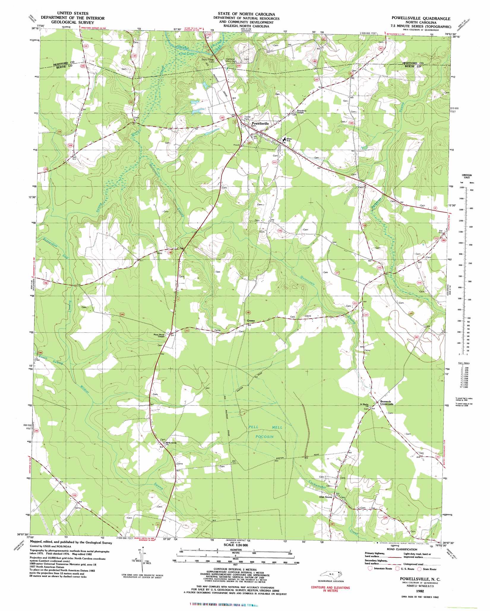
Powellsville Topo Map North Carolina
To zoom in, hover over the map of Powellsville
USGS Topo Quad 36076b8 - 1:24,000 scale
| Topo Map Name: | Powellsville |
| USGS Topo Quad ID: | 36076b8 |
| Print Size: | ca. 21 1/4" wide x 27" high |
| Southeast Coordinates: | 36.125° N latitude / 76.875° W longitude |
| Map Center Coordinates: | 36.1875° N latitude / 76.9375° W longitude |
| U.S. State: | NC |
| Filename: | o36076b8.jpg |
| Download Map JPG Image: | Powellsville topo map 1:24,000 scale |
| Map Type: | Topographic |
| Topo Series: | 7.5´ |
| Map Scale: | 1:24,000 |
| Source of Map Images: | United States Geological Survey (USGS) |
| Alternate Map Versions: |
Powellsville NC 1982, updated 1982 Download PDF Buy paper map Powellsville NC 2000, updated 2002 Download PDF Buy paper map Powellsville NC 2010 Download PDF Buy paper map Powellsville NC 2013 Download PDF Buy paper map Powellsville NC 2016 Download PDF Buy paper map |
1:24,000 Topo Quads surrounding Powellsville
Conway |
Murfreesboro |
Winton |
Gatesville |
Merchants Millpond |
Woodland |
Union |
Ahoskie |
Harrellsville |
Mintonsville |
Kelford |
Aulander |
Powellsville |
Colerain |
Valhalla |
Woodville |
Republican |
Windsor North |
Merry Hill |
Edenhouse |
Hamilton |
Quitsna |
Windsor South |
Woodard |
Westover |
> Back to 36076a1 at 1:100,000 scale
> Back to 36076a1 at 1:250,000 scale
> Back to U.S. Topo Maps home
Powellsville topo map: Gazetteer
Powellsville: Populated Places
Buzzards Crossroads elevation 19m 62′Cremo elevation 19m 62′
Elm Grove elevation 17m 55′
Powellsville elevation 20m 65′
Powellsville: Streams
Beaverdam Swamp elevation 9m 29′Eason Swamp elevation 10m 32′
Loosing Swamp elevation 7m 22′
Quioccosin Swamp elevation 7m 22′
Stony Creek elevation 5m 16′
Wildcat Swamp elevation 10m 32′
Powellsville digital topo map on disk
Buy this Powellsville topo map showing relief, roads, GPS coordinates and other geographical features, as a high-resolution digital map file on DVD:
Atlantic Coast (NY, NJ, PA, DE, MD, VA, NC)
Buy digital topo maps: Atlantic Coast (NY, NJ, PA, DE, MD, VA, NC)
 map DVD")