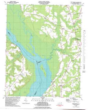
Mintonsville Topo Map North Carolina
To zoom in, hover over the map of Mintonsville
USGS Topo Quad 36076c6 - 1:24,000 scale
| Topo Map Name: | Mintonsville |
| USGS Topo Quad ID: | 36076c6 |
| Print Size: | ca. 21 1/4" wide x 27" high |
| Southeast Coordinates: | 36.25° N latitude / 76.625° W longitude |
| Map Center Coordinates: | 36.3125° N latitude / 76.6875° W longitude |
| U.S. State: | NC |
| Filename: | o36076c6.jpg |
| Download Map JPG Image: | Mintonsville topo map 1:24,000 scale |
| Map Type: | Topographic |
| Topo Series: | 7.5´ |
| Map Scale: | 1:24,000 |
| Source of Map Images: | United States Geological Survey (USGS) |
| Alternate Map Versions: |
Mintonsville NC 1982, updated 1982 Download PDF Buy paper map Mintonsville NC 1997, updated 2000 Download PDF Buy paper map Mintonsville NC 2010 Download PDF Buy paper map Mintonsville NC 2013 Download PDF Buy paper map Mintonsville NC 2016 Download PDF Buy paper map |
1:24,000 Topo Quads surrounding Mintonsville
> Back to 36076a1 at 1:100,000 scale
> Back to 36076a1 at 1:250,000 scale
> Back to U.S. Topo Maps home
Mintonsville topo map: Gazetteer
Mintonsville: Capes
Horn Point elevation 7m 22′Mintonsville: Islands
Holiday Island elevation 0m 0′Mintonsville: Populated Places
Cannon Ferry elevation 3m 9′Carter elevation 6m 19′
Chowan elevation 7m 22′
Hutson Corner elevation 11m 36′
Icaria elevation 8m 26′
Lloyd Crossroads elevation 19m 62′
Mintonsville elevation 8m 26′
Mitchells Fork elevation 8m 26′
Mount Rose elevation 7m 22′
Muddy Cross elevation 11m 36′
Old Chapel Crossroads elevation 7m 22′
Powell Crossroads elevation 7m 22′
Walton Crossroads elevation 9m 29′
Mintonsville: Reservoirs
Taylor Millpond elevation 0m 0′Welsh Pond elevation 1m 3′
Mintonsville: Streams
Beef Creek elevation 2m 6′Bennetts Creek elevation 0m 0′
Catherine Creek elevation 0m 0′
Deep Swamp Branch elevation 0m 0′
Goose Creek elevation 1m 3′
Stumpy Creek elevation 0m 0′
Trotman Creek elevation 1m 3′
Warwick Creek elevation 1m 3′
Mintonsville: Swamps
Honey Pot Swamp elevation 1m 3′Mintonsville digital topo map on disk
Buy this Mintonsville topo map showing relief, roads, GPS coordinates and other geographical features, as a high-resolution digital map file on DVD:
Atlantic Coast (NY, NJ, PA, DE, MD, VA, NC)
Buy digital topo maps: Atlantic Coast (NY, NJ, PA, DE, MD, VA, NC)


