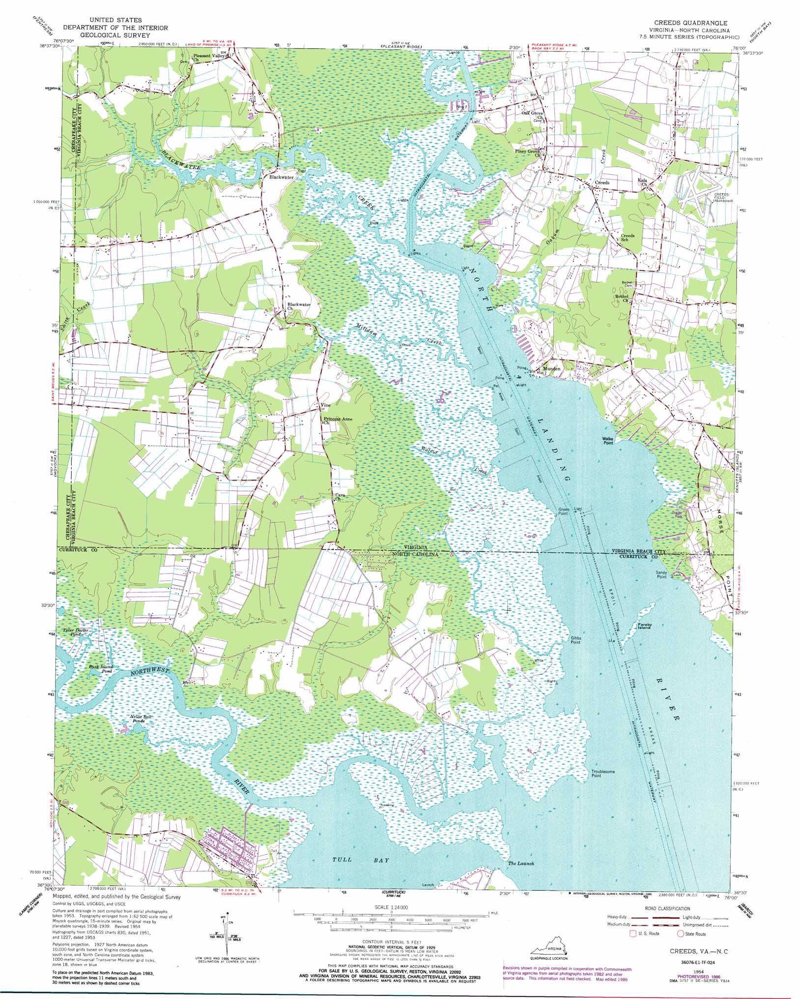
Creeds Topo Map Virginia
To zoom in, hover over the map of Creeds
USGS Topo Quad 36076e1 - 1:24,000 scale
| Topo Map Name: | Creeds |
| USGS Topo Quad ID: | 36076e1 |
| Print Size: | ca. 21 1/4" wide x 27" high |
| Southeast Coordinates: | 36.5° N latitude / 76° W longitude |
| Map Center Coordinates: | 36.5625° N latitude / 76.0625° W longitude |
| U.S. States: | VA, NC |
| Filename: | o36076e1.jpg |
| Download Map JPG Image: | Creeds topo map 1:24,000 scale |
| Map Type: | Topographic |
| Topo Series: | 7.5´ |
| Map Scale: | 1:24,000 |
| Source of Map Images: | United States Geological Survey (USGS) |
| Alternate Map Versions: |
Creeds VA 1954, updated 1956 Download PDF Buy paper map Creeds VA 1954, updated 1966 Download PDF Buy paper map Creeds VA 1954, updated 1972 Download PDF Buy paper map Creeds VA 1954, updated 1986 Download PDF Buy paper map Creeds VA 1977, updated 1979 Download PDF Buy paper map Creeds VA 2011 Download PDF Buy paper map Creeds VA 2013 Download PDF Buy paper map Creeds VA 2016 Download PDF Buy paper map |
1:24,000 Topo Quads surrounding Creeds
Norfolk South |
Kempsville |
Princess Anne |
Virginia Beach |
|
Deep Creek |
Fentress |
Pleasant Ridge |
North Bay |
|
Lake Drummond Se |
Moyock |
Creeds |
Knotts Island |
|
South Mills |
Lambs Corner |
Currituck |
Barco |
Corolla |
Pasquotank |
Elizabeth City |
Shiloh |
Coinjock |
Mossey Islands |
> Back to 36076e1 at 1:100,000 scale
> Back to 36076a1 at 1:250,000 scale
> Back to U.S. Topo Maps home
Creeds topo map: Gazetteer
Creeds: Airports
Creeds Field (historical) elevation 2m 6′Creeds Heliport elevation 1m 3′
Creeds: Bays
Tull Bay elevation 0m 0′Creeds: Capes
Gibbs Point elevation 0m 0′Green Point elevation 0m 0′
Munden Point elevation 1m 3′
Sandy Point elevation 0m 0′
Troublesome Point elevation 0m 0′
Walke Point elevation 0m 0′
Creeds: Channels
The Launch elevation 0m 0′Creeds: Islands
Faraby Island elevation 0m 0′Hog Island elevation 0m 0′
Creeds: Lakes
Buck Island Pond elevation 0m 0′Nellie Bell Ponds elevation 0m 0′
Peter Dozier Pond elevation 0m 0′
Creeds: Populated Places
Blackwater elevation 3m 9′Creeds elevation 2m 6′
Greentown elevation 0m 0′
Munden elevation 2m 6′
Pungo Ferry elevation 1m 3′
Vine elevation 3m 9′
Creeds: Streams
Blackwater Creek elevation 0m 0′Milldam Creek elevation 0m 0′
Northwest River elevation 0m 0′
Oakum Creek elevation 1m 3′
Snake Creek elevation 0m 0′
Walnut Creek elevation 0m 0′
Creeds: Woods
Gibbs Woods elevation 1m 3′Creeds digital topo map on disk
Buy this Creeds topo map showing relief, roads, GPS coordinates and other geographical features, as a high-resolution digital map file on DVD:
Atlantic Coast (NY, NJ, PA, DE, MD, VA, NC)
Buy digital topo maps: Atlantic Coast (NY, NJ, PA, DE, MD, VA, NC)
 map DVD")