Cape Henry Topo Map Virginia
To zoom in, hover over the map of Cape Henry
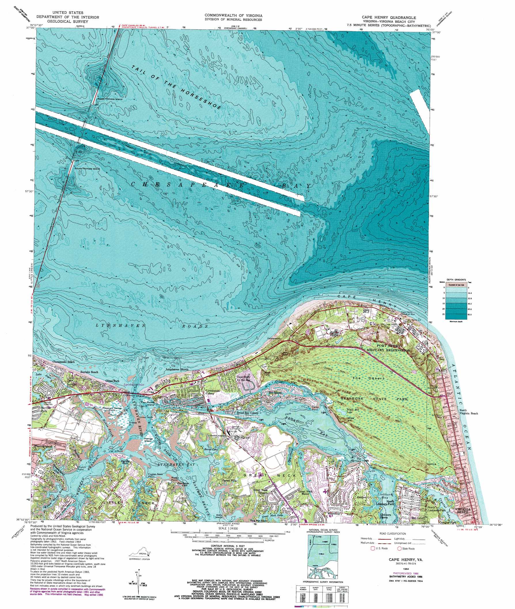
USGS Topo Quad 36076h1 - 1:24,000 scale
| Topo Map Name: | Cape Henry |
| USGS Topo Quad ID: | 36076h1 |
| Print Size: | ca. 21 1/4" wide x 27" high |
| Southeast Coordinates: | 36.875° N latitude / 76° W longitude |
| Map Center Coordinates: | 36.9375° N latitude / 76.0625° W longitude |
| U.S. State: | VA |
| Filename: | o36076h1.jpg |
| Download Map JPG Image: | Cape Henry topo map 1:24,000 scale |
| Map Type: | Topographic |
| Topo Series: | 7.5´ |
| Map Scale: | 1:24,000 |
| Source of Map Images: | United States Geological Survey (USGS) |
| Alternate Map Versions: |
Cape Henry VA 1952 Download PDF Buy paper map Cape Henry VA 1955, updated 1958 Download PDF Buy paper map Cape Henry VA 1964, updated 1967 Download PDF Buy paper map Cape Henry VA 1964, updated 1971 Download PDF Buy paper map Cape Henry VA 1964, updated 1974 Download PDF Buy paper map Cape Henry VA 1964, updated 1980 Download PDF Buy paper map Cape Henry VA 1964, updated 1987 Download PDF Buy paper map Cape Henry VA 2010 Download PDF Buy paper map Cape Henry VA 2013 Download PDF Buy paper map Cape Henry VA 2016 Download PDF Buy paper map |
1:24,000 Topo Quads surrounding Cape Henry
Poquoson East |
East Of Poquoson East |
Elliotts Creek |
Townsend |
Ship Shoal Inlet |
Hampton |
East Of Hampton |
Chesapeake Channel |
Fishermans Island |
|
Norfolk North |
Little Creek |
Cape Henry |
North Virginia Beach |
|
Norfolk South |
Kempsville |
Princess Anne |
Virginia Beach |
|
Deep Creek |
Fentress |
Pleasant Ridge |
North Bay |
> Back to 36076e1 at 1:100,000 scale
> Back to 36076a1 at 1:250,000 scale
> Back to U.S. Topo Maps home
Cape Henry topo map: Gazetteer
Cape Henry: Bays
Broad Bay elevation 2m 6′Brock Cove elevation -3m -10′
Dey Cove elevation 0m 0′
Keeling Cove elevation 0m 0′
Linkhorn Bay elevation 5m 16′
Lynnhaven Bay elevation 0m 0′
Lynnhaven Inlet elevation 0m 0′
Lynnhaven Roads elevation 0m 0′
Poorhouse Cove elevation 1m 3′
Thoroughgood Cove elevation 0m 0′
Witch Duck Bay elevation 0m 0′
Cape Henry: Bridges
Lesner Bridge elevation 0m 0′Cape Henry: Capes
Cape Henry elevation 0m 0′Caraway Point elevation 0m 0′
Carter Point elevation 2m 6′
Church Point elevation 0m 0′
Eagles Nest Point elevation 1m 3′
Grassy Point elevation 0m 0′
Great Neck elevation 7m 22′
Great Neck Point elevation 1m 3′
Hill Point elevation 2m 6′
Little Neck elevation 5m 16′
Log House Point elevation 0m 0′
Mapps Point elevation 0m 0′
Pleasure House Point elevation 1m 3′
Sandy Point elevation 4m 13′
Cape Henry: Channels
North Auxiliary Channel elevation 0m 0′South Auxiliary Channel elevation 0m 0′
The Narrows elevation 0m 0′
Cape Henry: Dams
Great Neck Dam elevation 2m 6′Thoroughgood Dam elevation 3m 9′
Cape Henry: Guts
Bayville Creek elevation 4m 13′Crab Creek elevation 0m 0′
Keeling Drain elevation 0m 0′
Long Creek elevation 0m 0′
Pleasure House Creek elevation 0m 0′
Cape Henry: Islands
Avery Island elevation 3m 9′Fish House Island elevation 0m 0′
Humes Island elevation 1m 3′
North Thimble Island elevation 0m 0′
South Thimble Island elevation 0m 0′
Cape Henry: Parks
Bayville Farms Park elevation 7m 22′First Landing State Park elevation 3m 9′
Cape Henry: Pillars
Cape Henry Memorial elevation 5m 16′Cape Henry: Populated Places
Alanton elevation 7m 22′Bay Colony elevation 4m 13′
Bay Island elevation 2m 6′
Baylake Beach elevation 3m 9′
Baylake Pines elevation 5m 16′
Bayville elevation 4m 13′
Bayville Park elevation 5m 16′
Broad Bay Colony elevation 1m 3′
Cape Henry Village elevation 4m 13′
Cape Story by the Sea elevation 1m 3′
Chesapeake Beach elevation 2m 6′
Forest Hills elevation 3m 9′
Great Neck Estates elevation 4m 13′
Great Neck Manor elevation 4m 13′
Linkhorn Shores elevation 3m 9′
Lynnhaven Colony elevation 1m 3′
Lynnhaven Shores elevation 2m 6′
North Linkhorn Park elevation 4m 13′
Ocean Park elevation 3m 9′
Cape Henry: Post Offices
Cape Henry Post Office elevation 4m 13′Fort Story Station Virginia Beach Post Office elevation 4m 13′
Cape Henry: Reservoirs
Great Neck Lake elevation 2m 6′Lake Charles elevation 3m 9′
Lake Joyce elevation 2m 6′
White Hill Lake elevation 0m 0′
Cape Henry: Streams
Dix Creek elevation 0m 0′Eastern Branch Lynnhaven River elevation 0m 0′
Lynnhaven River elevation 0m 0′
Mill Dam Creek elevation 2m 6′
Western Branch Lynnhaven River elevation 0m 0′
Cape Henry: Summits
White Hill elevation 10m 32′Cape Henry: Swamps
The Desert elevation 3m 9′Cape Henry: Trails
High Dune Trail elevation 3m 9′Lagoon Trail elevation 3m 9′
Long Creek Trail elevation 3m 9′
Main Trail elevation 3m 9′
Osmanthus Trail elevation 3m 9′
White Hill Lake Trail elevation 2m 6′
Cape Henry: Tunnels
Thimble Shoal Channel Tunnel elevation 0m 0′Cape Henry digital topo map on disk
Buy this Cape Henry topo map showing relief, roads, GPS coordinates and other geographical features, as a high-resolution digital map file on DVD:
Atlantic Coast (NY, NJ, PA, DE, MD, VA, NC)
Buy digital topo maps: Atlantic Coast (NY, NJ, PA, DE, MD, VA, NC)
 map DVD")