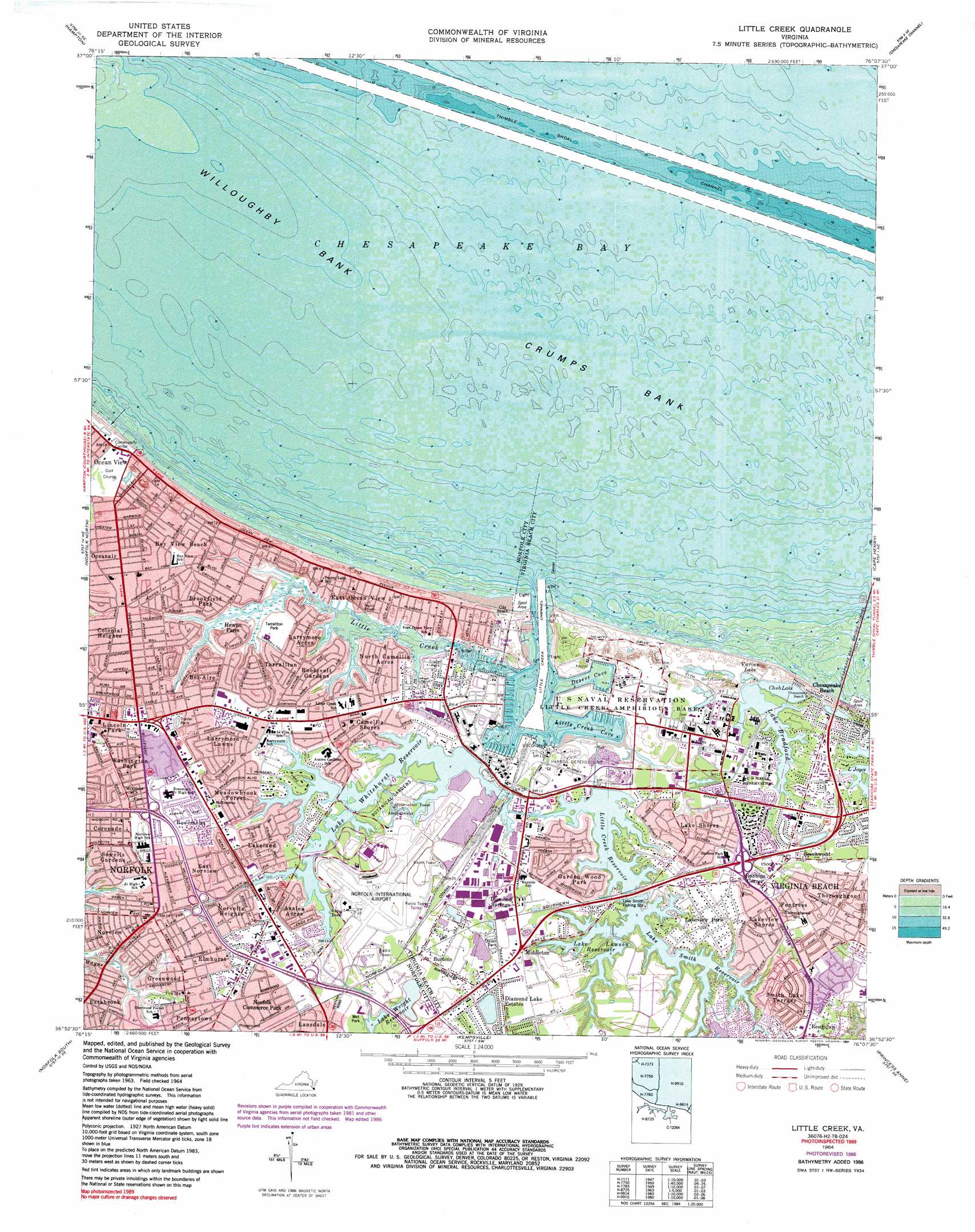
Little Creek Topo Map Virginia
To zoom in, hover over the map of Little Creek
USGS Topo Quad 36076h2 - 1:24,000 scale
| Topo Map Name: | Little Creek |
| USGS Topo Quad ID: | 36076h2 |
| Print Size: | ca. 21 1/4" wide x 27" high |
| Southeast Coordinates: | 36.875° N latitude / 76.125° W longitude |
| Map Center Coordinates: | 36.9375° N latitude / 76.1875° W longitude |
| U.S. State: | VA |
| Filename: | o36076h2.jpg |
| Download Map JPG Image: | Little Creek topo map 1:24,000 scale |
| Map Type: | Topographic |
| Topo Series: | 7.5´ |
| Map Scale: | 1:24,000 |
| Source of Map Images: | United States Geological Survey (USGS) |
| Alternate Map Versions: |
Ocean View VA 1948 Download PDF Buy paper map Ocean View VA 1954, updated 1958 Download PDF Buy paper map Little Creek VA 1964, updated 1968 Download PDF Buy paper map Little Creek VA 1964, updated 1971 Download PDF Buy paper map Little Creek VA 1964, updated 1980 Download PDF Buy paper map Little Creek VA 1964, updated 1987 Download PDF Buy paper map Little Creek VA 1964, updated 1991 Download PDF Buy paper map Little Creek VA 2011 Download PDF Buy paper map Little Creek VA 2013 Download PDF Buy paper map Little Creek VA 2016 Download PDF Buy paper map |
1:24,000 Topo Quads surrounding Little Creek
Poquoson West |
Poquoson East |
East Of Poquoson East |
Elliotts Creek |
Townsend |
Newport News North |
Hampton |
East Of Hampton |
Chesapeake Channel |
Fishermans Island |
Newport News South |
Norfolk North |
Little Creek |
Cape Henry |
North Virginia Beach |
Bowers Hill |
Norfolk South |
Kempsville |
Princess Anne |
Virginia Beach |
Lake Drummond Nw |
Deep Creek |
Fentress |
Pleasant Ridge |
North Bay |
> Back to 36076e1 at 1:100,000 scale
> Back to 36076a1 at 1:250,000 scale
> Back to U.S. Topo Maps home
Little Creek topo map: Gazetteer
Little Creek: Airports
Norfolk International Airport elevation 7m 22′Little Creek: Areas
Norfolk Municipal Azalea Gardens elevation 3m 9′Little Creek: Bays
Desert Cove elevation 0m 0′Fishermans Cove elevation 0m 0′
Little Creek Cove elevation 0m 0′
Little Creek: Capes
Pleasure House Point (historical) elevation 4m 13′Little Creek: Channels
Little Creek Channel elevation 0m 0′Thimble Shoal Channel elevation 0m 0′
Little Creek: Crossings
Interchange 218 elevation 7m 22′Interchange 279 elevation 9m 29′
Interchange 281 elevation 5m 16′
Little Creek: Dams
Little Creek Dam elevation 2m 6′Little Creek Dam elevation 2m 6′
Little Creek: Harbors
Little Creek Harbor elevation 0m 0′Little Creek: Lakes
Lake Pleasure House elevation 1m 3′Little Creek: Levees
Crumps Bank elevation 0m 0′Little Creek: Parks
East Ocean View Community Park elevation 0m 0′Metropolitan Municipal Stadium elevation 3m 9′
Tarrallton Park elevation 4m 13′
Little Creek: Populated Places
Alden Heights elevation 4m 13′Azalea Acres elevation 4m 13′
Bay View Beach elevation 3m 9′
Bayside elevation 3m 9′
Bayview Mobile Home Park elevation 4m 13′
Beechwood elevation 7m 22′
Bel-Aire elevation 4m 13′
Brandon Place elevation 4m 13′
Brentwood elevation 4m 13′
Brookfield Park elevation 3m 9′
Burtons elevation 6m 19′
Camden Heights elevation 6m 19′
Camellia Shores elevation 3m 9′
Cherokee Heights elevation 4m 13′
Colonial Heights elevation 4m 13′
Colonial Run Mobile Home Park elevation 6m 19′
Coronado elevation 4m 13′
Cottage Park elevation 4m 13′
Daugherty Trailer Court elevation 3m 9′
Diamond Lake Estates elevation 6m 19′
East Norview elevation 5m 16′
East Ocean View elevation 2m 6′
El Dorado Trailer Park elevation 3m 9′
Elmhurst elevation 4m 13′
Estabrook elevation 3m 9′
Fentress elevation 8m 26′
Forest Park elevation 5m 16′
Garden Wood Park elevation 6m 19′
Greenwood elevation 3m 9′
Hewitt Farm elevation 4m 13′
Hogshires Trailer Court elevation 4m 13′
Hyde Park Homes elevation 4m 13′
Lake Shores elevation 3m 9′
Lake Smith elevation 5m 16′
Lakeland elevation 4m 13′
Lakeview Park elevation 6m 19′
Lakeview Shores elevation 7m 22′
Lansdale elevation 5m 16′
Larrymore Acres elevation 3m 9′
Larrymore Lawns elevation 5m 16′
Lincoln Park elevation 5m 16′
Little Creek elevation 3m 9′
Meadowbrook Forest elevation 4m 13′
Middleton elevation 7m 22′
North Camellia Acres elevation 3m 9′
Norvella Heights elevation 4m 13′
Norview elevation 4m 13′
Norview Gardens elevation 4m 13′
Norview Heights elevation 3m 9′
Oakwood elevation 5m 16′
Ocean View elevation 3m 9′
Oceanair elevation 4m 13′
Pennsytown elevation 3m 9′
Pooles elevation 4m 13′
Princess Anne Mobile Home Park elevation 3m 9′
Reedtown elevation 8m 26′
Robbins Corner elevation 8m 26′
Roosevelt Gardens elevation 3m 9′
Rosemont elevation 5m 16′
Sewells Gardens elevation 4m 13′
Smith Lake Terrace elevation 7m 22′
Snug Harbor elevation 3m 9′
South Bay View elevation 4m 13′
Tarrallton elevation 3m 9′
Thoroughgood elevation 7m 22′
Washington Park elevation 5m 16′
Wedgewood elevation 3m 9′
Little Creek: Post Offices
Bayside Station Virginia Beach Post Office elevation 3m 9′L C Page Post Office elevation 4m 13′
Norview Station Norfolk Post Office elevation 4m 13′
West Annex Post Office elevation 4m 13′
Little Creek: Reservoirs
Chub Lake elevation 1m 3′Lake Bradford elevation 1m 3′
Lake Lawson elevation 3m 9′
Lake Smith elevation 3m 9′
Lake Whitehurst elevation 2m 6′
Lake Wright elevation 3m 9′
Little Creek Reservoir elevation 2m 6′
Varian Lake elevation 1m 3′
Little Creek: Streams
Little Creek elevation 0m 0′Talbots Branch elevation 1m 3′
Little Creek digital topo map on disk
Buy this Little Creek topo map showing relief, roads, GPS coordinates and other geographical features, as a high-resolution digital map file on DVD:
Atlantic Coast (NY, NJ, PA, DE, MD, VA, NC)
Buy digital topo maps: Atlantic Coast (NY, NJ, PA, DE, MD, VA, NC)
 map DVD")