Smithfield Topo Map Virginia
To zoom in, hover over the map of Smithfield
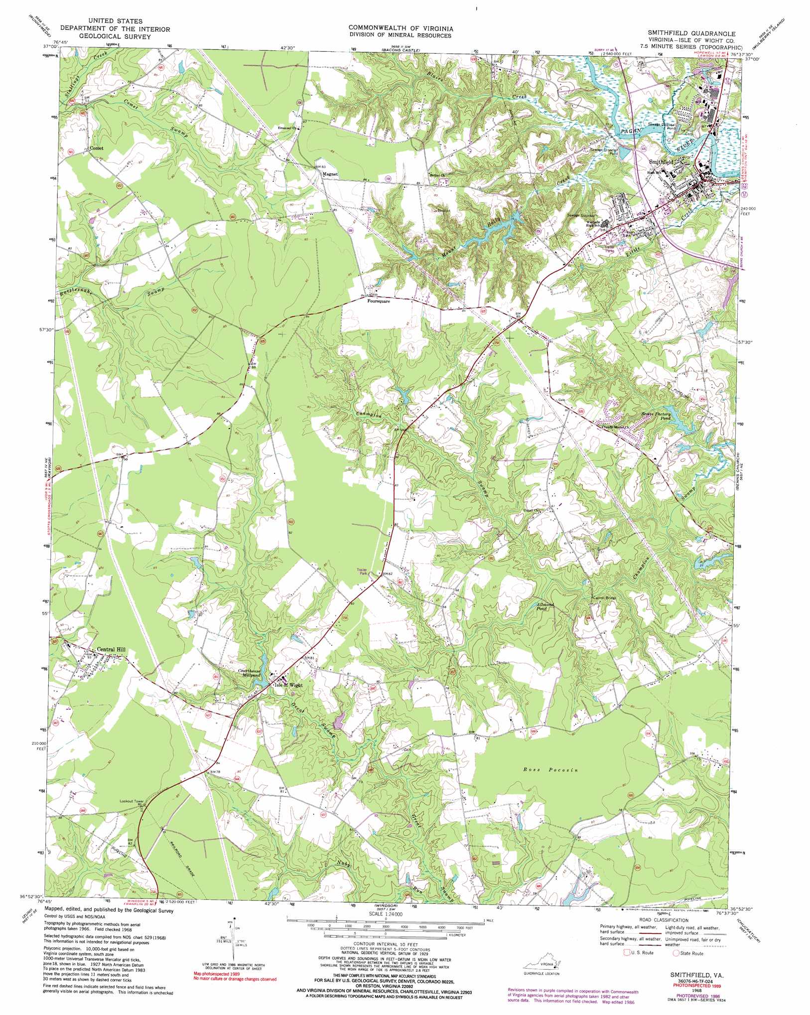
USGS Topo Quad 36076h6 - 1:24,000 scale
| Topo Map Name: | Smithfield |
| USGS Topo Quad ID: | 36076h6 |
| Print Size: | ca. 21 1/4" wide x 27" high |
| Southeast Coordinates: | 36.875° N latitude / 76.625° W longitude |
| Map Center Coordinates: | 36.9375° N latitude / 76.6875° W longitude |
| U.S. State: | VA |
| Filename: | o36076h6.jpg |
| Download Map JPG Image: | Smithfield topo map 1:24,000 scale |
| Map Type: | Topographic |
| Topo Series: | 7.5´ |
| Map Scale: | 1:24,000 |
| Source of Map Images: | United States Geological Survey (USGS) |
| Alternate Map Versions: |
Smithfield VA 1944, updated 1961 Download PDF Buy paper map Smithfield VA 1968, updated 1970 Download PDF Buy paper map Smithfield VA 1968, updated 1980 Download PDF Buy paper map Smithfield VA 1968, updated 1986 Download PDF Buy paper map Smithfield VA 1968, updated 1991 Download PDF Buy paper map Smithfield VA 2010 Download PDF Buy paper map Smithfield VA 2013 Download PDF Buy paper map Smithfield VA 2016 Download PDF Buy paper map |
1:24,000 Topo Quads surrounding Smithfield
Claremont |
Surry |
Hog Island |
Yorktown |
Poquoson West |
Dendron |
Runnymede |
Bacons Castle |
Mulberry Island |
Newport News North |
Ivor |
Raynor |
Smithfield |
Benns Church |
Newport News South |
Sedley |
Zuni |
Windsor |
Chuckatuck |
Bowers Hill |
Franklin |
Holland |
Buckhorn |
Suffolk |
Lake Drummond Nw |
> Back to 36076e1 at 1:100,000 scale
> Back to 36076a1 at 1:250,000 scale
> Back to U.S. Topo Maps home
Smithfield topo map: Gazetteer
Smithfield: Bridges
Carroll Bridge elevation 5m 16′Smithfield: Dams
Butlers Dam elevation 14m 45′Echo Dam elevation 7m 22′
Edwards Dam elevation 6m 19′
Smithfield Lake Dam elevation 5m 16′
Smithfield: Parks
Smithfield Historic District elevation 10m 32′Smithfield: Populated Places
Bethel Church elevation 26m 85′Blairs Creek Mobile Home Park elevation 23m 75′
Central Hill elevation 29m 95′
Comet elevation 24m 78′
Foursquare elevation 24m 78′
Isle of Wight elevation 18m 59′
Lakeside Manufactured Home Community elevation 24m 78′
Magnet elevation 24m 78′
Smithfield elevation 9m 29′
Smithfield: Post Offices
Smithfield Post Office elevation 10m 32′Smithfield: Reservoirs
Allmond Pond elevation 7m 22′Butlers Lake elevation 14m 45′
Courthouse Millpond elevation 14m 45′
Echo Lake elevation 7m 22′
Edwards Pond elevation 6m 19′
Nuby Bridge Pond (historical) elevation 10m 32′
Scotts Factory Pond elevation 6m 19′
Smithfield Lake elevation 5m 16′
Smithfield: Streams
Blairs Creek elevation 1m 3′Mount Holly Creek elevation 1m 3′
Nuby Run elevation 10m 32′
Smithfield: Swamps
Ross Pocosin elevation 24m 78′Smithfield digital topo map on disk
Buy this Smithfield topo map showing relief, roads, GPS coordinates and other geographical features, as a high-resolution digital map file on DVD:
Atlantic Coast (NY, NJ, PA, DE, MD, VA, NC)
Buy digital topo maps: Atlantic Coast (NY, NJ, PA, DE, MD, VA, NC)
 map DVD")