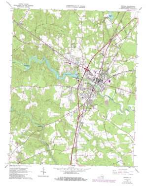
Emporia Topo Map Virginia
To zoom in, hover over the map of Emporia
USGS Topo Quad 36077f5 - 1:24,000 scale
| Topo Map Name: | Emporia |
| USGS Topo Quad ID: | 36077f5 |
| Print Size: | ca. 21 1/4" wide x 27" high |
| Southeast Coordinates: | 36.625° N latitude / 77.5° W longitude |
| Map Center Coordinates: | 36.6875° N latitude / 77.5625° W longitude |
| U.S. State: | VA |
| Filename: | o36077f5.jpg |
| Download Map JPG Image: | Emporia topo map 1:24,000 scale |
| Map Type: | Topographic |
| Topo Series: | 7.5´ |
| Map Scale: | 1:24,000 |
| Source of Map Images: | United States Geological Survey (USGS) |
| Alternate Map Versions: |
Emporia VA 1963, updated 1964 Download PDF Buy paper map Emporia VA 1963, updated 1969 Download PDF Buy paper map Emporia VA 1963, updated 1974 Download PDF Buy paper map Emporia VA 1963, updated 1980 Download PDF Buy paper map Emporia VA 1963, updated 1986 Download PDF Buy paper map Emporia VA 2010 Download PDF Buy paper map Emporia VA 2013 Download PDF Buy paper map Emporia VA 2016 Download PDF Buy paper map |
1:24,000 Topo Quads surrounding Emporia
> Back to 36077e1 at 1:100,000 scale
> Back to 36076a1 at 1:250,000 scale
> Back to U.S. Topo Maps home
Emporia topo map: Gazetteer
Emporia: Airports
Greensville Memorial Hospital Heliport elevation 38m 124′Emporia: Crossings
Interchange 11 elevation 45m 147′Interchange 13 elevation 37m 121′
Interchange 8 elevation 44m 144′
Emporia: Dams
Emporia Dam elevation 33m 108′Slagles Dam elevation 35m 114′
Emporia: Parks
Meherrin River Park elevation 28m 91′Veterans Memorial Park elevation 28m 91′
Emporia: Populated Places
Bufford Crossroads elevation 49m 160′Dons Mobile Home Park elevation 57m 187′
Durand elevation 62m 203′
Emporia elevation 34m 111′
Greenwood Park elevation 48m 157′
Halifax Manor Mobile Home Park elevation 38m 124′
Kingsberry elevation 47m 154′
Lakeside Village Mobile Home Park elevation 42m 137′
Lanes Corner elevation 29m 95′
Lincoln Heights elevation 50m 164′
Magnums Mobile Home Park elevation 33m 108′
Moonlight elevation 33m 108′
North Emporia elevation 32m 104′
Pine View Mobile Home Park elevation 43m 141′
Walnut Heights elevation 43m 141′
Washington Park elevation 41m 134′
Westover Hills elevation 48m 157′
White City elevation 37m 121′
Emporia: Post Offices
Emporia Post Office elevation 28m 91′Emporia: Reservoirs
Emporia Lake elevation 33m 108′Meherrin River Reservoir elevation 33m 108′
Slagles Lake elevation 35m 114′
Emporia: Streams
Falling Run elevation 24m 78′Maclins Creek elevation 30m 98′
Metcalf Branch elevation 24m 78′
Emporia digital topo map on disk
Buy this Emporia topo map showing relief, roads, GPS coordinates and other geographical features, as a high-resolution digital map file on DVD:
Atlantic Coast (NY, NJ, PA, DE, MD, VA, NC)
Buy digital topo maps: Atlantic Coast (NY, NJ, PA, DE, MD, VA, NC)


