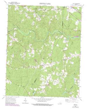
Ante Topo Map Virginia
To zoom in, hover over the map of Ante
USGS Topo Quad 36077f6 - 1:24,000 scale
| Topo Map Name: | Ante |
| USGS Topo Quad ID: | 36077f6 |
| Print Size: | ca. 21 1/4" wide x 27" high |
| Southeast Coordinates: | 36.625° N latitude / 77.625° W longitude |
| Map Center Coordinates: | 36.6875° N latitude / 77.6875° W longitude |
| U.S. State: | VA |
| Filename: | o36077f6.jpg |
| Download Map JPG Image: | Ante topo map 1:24,000 scale |
| Map Type: | Topographic |
| Topo Series: | 7.5´ |
| Map Scale: | 1:24,000 |
| Source of Map Images: | United States Geological Survey (USGS) |
| Alternate Map Versions: |
Ante VA 1963, updated 1964 Download PDF Buy paper map Ante VA 1963, updated 1980 Download PDF Buy paper map Ante VA 1963, updated 1990 Download PDF Buy paper map Ante VA 2010 Download PDF Buy paper map Ante VA 2013 Download PDF Buy paper map Ante VA 2016 Download PDF Buy paper map |
1:24,000 Topo Quads surrounding Ante
> Back to 36077e1 at 1:100,000 scale
> Back to 36076a1 at 1:250,000 scale
> Back to U.S. Topo Maps home
Ante topo map: Gazetteer
Ante: Bridges
Westward Bridge elevation 41m 134′Ante: Dams
Doyles Dam elevation 53m 173′Mitchells Dam elevation 44m 144′
Ante: Populated Places
Ante elevation 91m 298′Harris Crossroads elevation 90m 295′
Racume elevation 77m 252′
Radium elevation 61m 200′
Totaro elevation 70m 229′
Webbs Mill elevation 45m 147′
Ante: Reservoirs
Doyle Lake elevation 53m 173′Doyles Pond elevation 53m 173′
Mitchells Pond elevation 44m 144′
Ante: Streams
Brandy Creek elevation 38m 124′Douglas Run elevation 36m 118′
Greensville Creek elevation 36m 118′
Lightfoot Creek elevation 36m 118′
Meadows Branch elevation 36m 118′
Millpond Creek elevation 36m 118′
Reedy Creek elevation 36m 118′
Robinson Creek elevation 39m 127′
White Oak Creek elevation 57m 187′
Ante digital topo map on disk
Buy this Ante topo map showing relief, roads, GPS coordinates and other geographical features, as a high-resolution digital map file on DVD:
Atlantic Coast (NY, NJ, PA, DE, MD, VA, NC)
Buy digital topo maps: Atlantic Coast (NY, NJ, PA, DE, MD, VA, NC)


