White Plains Topo Map Virginia
To zoom in, hover over the map of White Plains
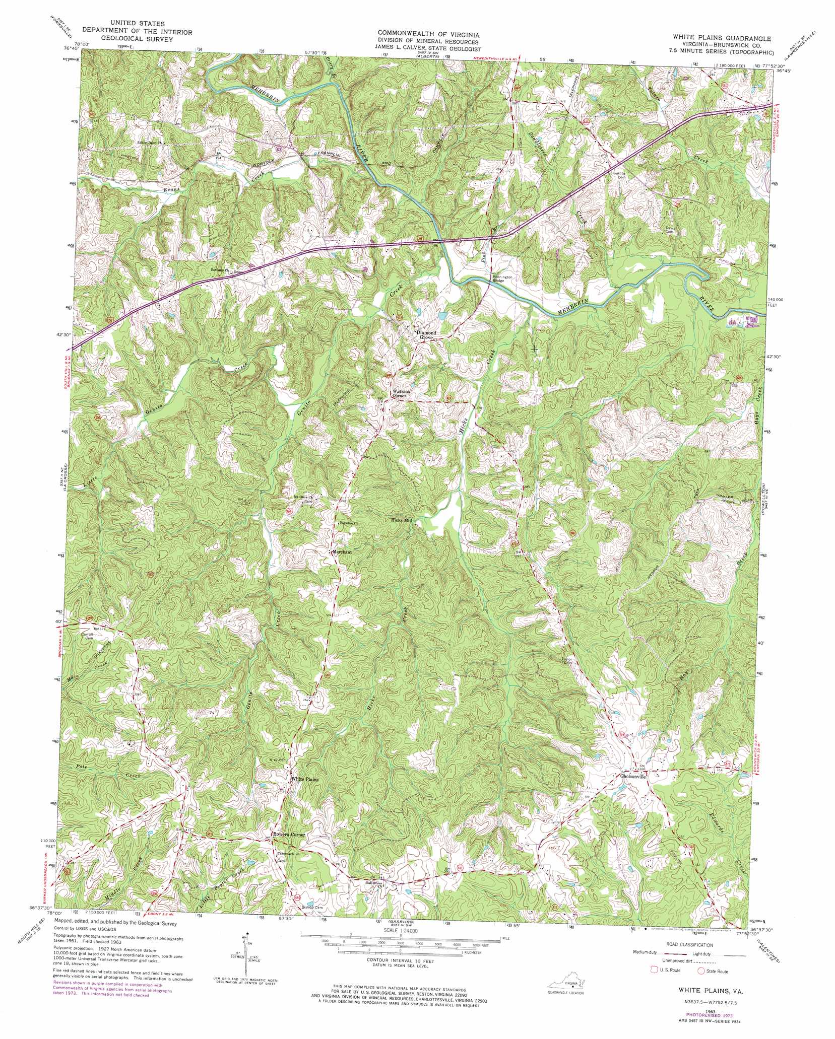
USGS Topo Quad 36077f8 - 1:24,000 scale
| Topo Map Name: | White Plains |
| USGS Topo Quad ID: | 36077f8 |
| Print Size: | ca. 21 1/4" wide x 27" high |
| Southeast Coordinates: | 36.625° N latitude / 77.875° W longitude |
| Map Center Coordinates: | 36.6875° N latitude / 77.9375° W longitude |
| U.S. State: | VA |
| Filename: | o36077f8.jpg |
| Download Map JPG Image: | White Plains topo map 1:24,000 scale |
| Map Type: | Topographic |
| Topo Series: | 7.5´ |
| Map Scale: | 1:24,000 |
| Source of Map Images: | United States Geological Survey (USGS) |
| Alternate Map Versions: |
White Plains VA 1963, updated 1965 Download PDF Buy paper map White Plains VA 1963, updated 1974 Download PDF Buy paper map White Plains VA 2010 Download PDF Buy paper map White Plains VA 2013 Download PDF Buy paper map White Plains VA 2016 Download PDF Buy paper map |
1:24,000 Topo Quads surrounding White Plains
Kenbridge West |
Kenbridge East |
Danieltown |
Warfield |
Mckenney |
North View |
Forksville |
Alberta |
Lawrenceville |
Smoky Ordinary |
South Hill |
La Crosse |
White Plains |
Powellton |
Ante |
Bracey |
South Hill Se |
Gasburg |
Valentines |
Barley |
Warrenton |
Macon |
Littleton |
Thelma |
Roanoke Rapids |
> Back to 36077e1 at 1:100,000 scale
> Back to 36076a1 at 1:250,000 scale
> Back to U.S. Topo Maps home
White Plains topo map: Gazetteer
White Plains: Bridges
Pennington Bridge elevation 52m 170′White Plains: Populated Places
Bowers Corner elevation 117m 383′Diamond Grove elevation 79m 259′
Gholsonville elevation 110m 360′
Hicks Mill elevation 62m 203′
Merchant elevation 93m 305′
Netta (historical) elevation 58m 190′
Watkins Corner elevation 97m 318′
White Plains elevation 108m 354′
White Plains: Streams
Briery Branch elevation 51m 167′Evans Creek elevation 52m 170′
Flat Branch elevation 48m 157′
Genito Creek elevation 48m 157′
Hicks Creek elevation 48m 157′
Little Genito Creek elevation 55m 180′
Saddletree Creek elevation 48m 157′
White Plains digital topo map on disk
Buy this White Plains topo map showing relief, roads, GPS coordinates and other geographical features, as a high-resolution digital map file on DVD:
Atlantic Coast (NY, NJ, PA, DE, MD, VA, NC)
Buy digital topo maps: Atlantic Coast (NY, NJ, PA, DE, MD, VA, NC)
 map DVD")