John H Kerr Dam Topo Map Virginia
To zoom in, hover over the map of John H Kerr Dam
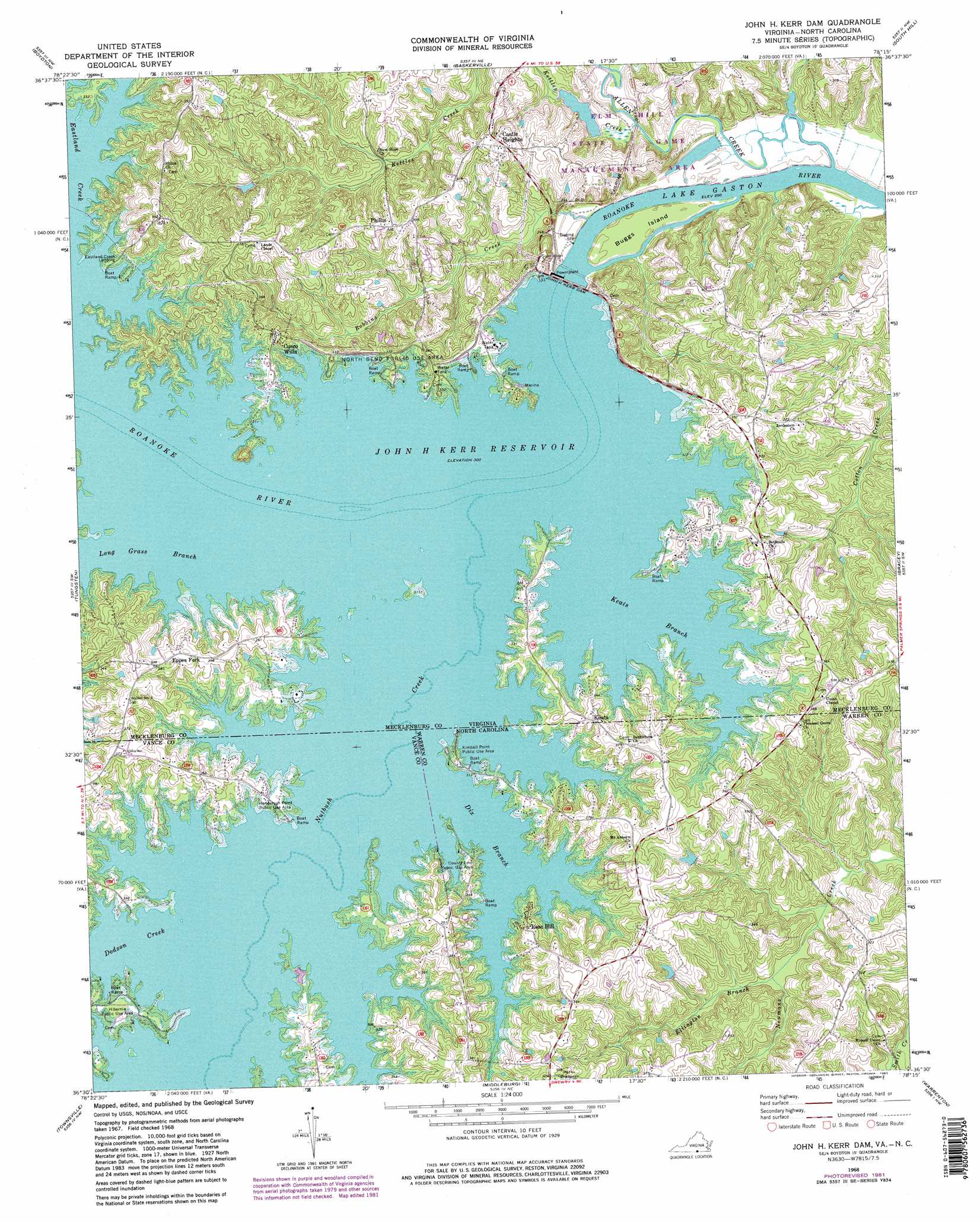
USGS Topo Quad 36078e3 - 1:24,000 scale
| Topo Map Name: | John H Kerr Dam |
| USGS Topo Quad ID: | 36078e3 |
| Print Size: | ca. 21 1/4" wide x 27" high |
| Southeast Coordinates: | 36.5° N latitude / 78.25° W longitude |
| Map Center Coordinates: | 36.5625° N latitude / 78.3125° W longitude |
| U.S. States: | VA, NC |
| Filename: | o36078e3.jpg |
| Download Map JPG Image: | John H Kerr Dam topo map 1:24,000 scale |
| Map Type: | Topographic |
| Topo Series: | 7.5´ |
| Map Scale: | 1:24,000 |
| Source of Map Images: | United States Geological Survey (USGS) |
| Alternate Map Versions: |
John H Kerr Dam VA 1968, updated 1972 Download PDF Buy paper map John H Kerr Dam VA 1968, updated 1975 Download PDF Buy paper map John H Kerr Dam VA 1968, updated 1981 Download PDF Buy paper map John H Kerr Dam VA 1968, updated 1981 Download PDF Buy paper map John H Kerr Dam VA 1977, updated 1978 Download PDF Buy paper map John H Kerr Dam VA 2011 Download PDF Buy paper map John H Kerr Dam VA 2013 Download PDF Buy paper map John H Kerr Dam VA 2016 Download PDF Buy paper map |
1:24,000 Topo Quads surrounding John H Kerr Dam
Wylliesburg |
Chase City |
Wightman |
North View |
Forksville |
Clarksville North |
Boydton |
Baskerville |
South Hill |
La Crosse |
Clarksville South |
Tungsten |
John H Kerr Dam |
Bracey |
South Hill Se |
Stovall |
Townsville |
Middleburg |
Warrenton |
Macon |
Oxford |
Henderson |
Vicksboro |
Afton |
Inez |
> Back to 36078e1 at 1:100,000 scale
> Back to 36078a1 at 1:250,000 scale
> Back to U.S. Topo Maps home
John H Kerr Dam topo map: Gazetteer
John H Kerr Dam: Bends
North Bend (historical) elevation 91m 298′John H Kerr Dam: Capes
Keats Peninsula elevation 103m 337′John H Kerr Dam: Crossings
Haskins Ferry (historical) elevation 91m 298′Roberts Ferry (historical) elevation 61m 200′
John H Kerr Dam: Dams
Hundley Dam elevation 63m 206′John H Kerr Dam elevation 71m 232′
John H Kerr Dam: Islands
Buggs Island elevation 66m 216′Gilligans Island elevation 92m 301′
John H Kerr Dam: Parks
Aurora Park elevation 100m 328′County Line Public Use Area elevation 102m 334′
Elm Hill State Game Management Area elevation 86m 282′
Henderson Point Public Use Area elevation 95m 311′
Hibernia Public Use Area elevation 100m 328′
Kimball Point Public Use Area elevation 99m 324′
North Bend Public Use Area elevation 100m 328′
Palmer Point Park elevation 96m 314′
Tailrace Park elevation 65m 213′
John H Kerr Dam: Populated Places
Castle Heights elevation 97m 318′Cusco Willa elevation 111m 364′
Eppes Fork elevation 114m 374′
Haskinton (historical) elevation 91m 298′
Keats elevation 108m 354′
Phillis elevation 100m 328′
Presbyterian Point elevation 96m 314′
Rose Hill elevation 110m 360′
Whits Point elevation 122m 400′
Wilson Fork elevation 103m 337′
John H Kerr Dam: Reservoirs
Hundley Pond elevation 63m 206′John H. Kerr Reservoir elevation 71m 232′
John H Kerr Dam: Streams
Allen Creek elevation 61m 200′Cox Creek elevation 64m 209′
Dix Branch elevation 91m 298′
Dodson Creek elevation 91m 298′
Eastland Creek elevation 91m 298′
Ellington Branch elevation 76m 249′
Keats Branch elevation 91m 298′
Keats Branch elevation 91m 298′
Kerse Branch elevation 91m 298′
Kettles Creek elevation 67m 219′
Long Grass Branch elevation 91m 298′
Long Grass Branch elevation 91m 298′
Nutbush Creek elevation 91m 298′
Nutbush Creek elevation 91m 298′
Robbins Creek elevation 61m 200′
John H Kerr Dam digital topo map on disk
Buy this John H Kerr Dam topo map showing relief, roads, GPS coordinates and other geographical features, as a high-resolution digital map file on DVD:
Western Virginia & Southern West Virginia
Buy digital topo maps: Western Virginia & Southern West Virginia