Tungsten Topo Map Virginia
To zoom in, hover over the map of Tungsten
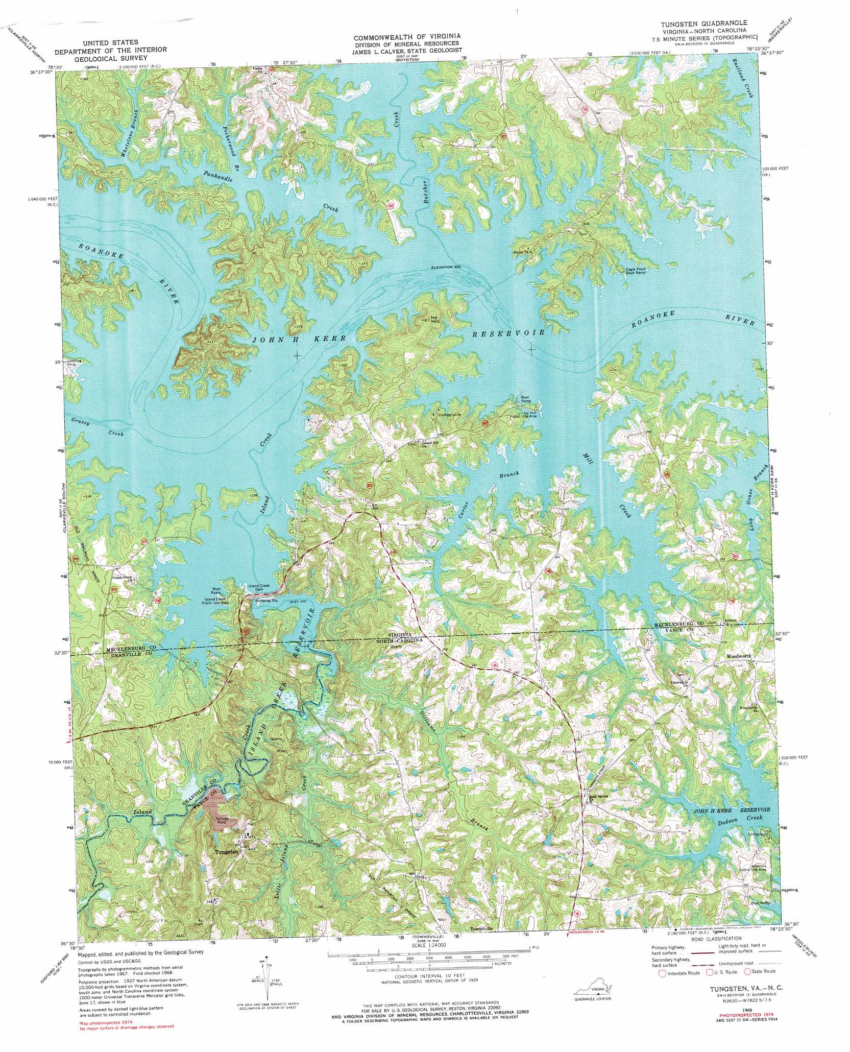
USGS Topo Quad 36078e4 - 1:24,000 scale
| Topo Map Name: | Tungsten |
| USGS Topo Quad ID: | 36078e4 |
| Print Size: | ca. 21 1/4" wide x 27" high |
| Southeast Coordinates: | 36.5° N latitude / 78.375° W longitude |
| Map Center Coordinates: | 36.5625° N latitude / 78.4375° W longitude |
| U.S. States: | VA, NC |
| Filename: | o36078e4.jpg |
| Download Map JPG Image: | Tungsten topo map 1:24,000 scale |
| Map Type: | Topographic |
| Topo Series: | 7.5´ |
| Map Scale: | 1:24,000 |
| Source of Map Images: | United States Geological Survey (USGS) |
| Alternate Map Versions: |
Tungsten NC 1968, updated 1972 Download PDF Buy paper map Tungsten NC 1968, updated 1977 Download PDF Buy paper map Tungsten NC 1977, updated 1978 Download PDF Buy paper map Tungsten NC 2011 Download PDF Buy paper map Tungsten NC 2013 Download PDF Buy paper map Tungsten NC 2016 Download PDF Buy paper map |
1:24,000 Topo Quads surrounding Tungsten
Clover |
Wylliesburg |
Chase City |
Wightman |
North View |
Buffalo Springs |
Clarksville North |
Boydton |
Baskerville |
South Hill |
Nelson |
Clarksville South |
Tungsten |
John H Kerr Dam |
Bracey |
Satterwhite |
Stovall |
Townsville |
Middleburg |
Warrenton |
Berea |
Oxford |
Henderson |
Vicksboro |
Afton |
> Back to 36078e1 at 1:100,000 scale
> Back to 36078a1 at 1:250,000 scale
> Back to U.S. Topo Maps home
Tungsten topo map: Gazetteer
Tungsten: Bends
South Bend (historical) elevation 91m 298′Tungsten: Crossings
Fields Ferry (historical) elevation 91m 298′Tungsten: Dams
Island Creek Dam elevation 95m 311′Tungsten: Falls
Eagle Point Falls (historical) elevation 91m 298′Tungsten: Islands
Big Island elevation 96m 314′Clydes Island elevation 91m 298′
Cooper Island elevation 91m 298′
Fields Island (historical) elevation 91m 298′
Goats Island elevation 97m 318′
Hundred Islands (historical) elevation 91m 298′
Terrys Island (historical) elevation 91m 298′
Tungsten: Parks
Cedar Grove Wildlife Management Area elevation 95m 311′Eagle Point Wildlife Management Area elevation 99m 324′
Island Creek Public Use Area elevation 99m 324′
Ivy Hill Public Use Area elevation 107m 351′
Oakleaf Wildlife Management Area elevation 103m 337′
Tungsten: Populated Places
Ponderosa elevation 105m 344′Richardson elevation 122m 400′
Tungsten elevation 128m 419′
Woodworth elevation 112m 367′
Tungsten: Reservoirs
Island Creek Reservoir elevation 84m 275′Tungsten: Streams
Butcher Creek elevation 91m 298′Carter Branch elevation 91m 298′
Carter Branch elevation 91m 298′
Gilliams Branch elevation 77m 252′
Gilliams Branch elevation 77m 252′
Grassy Creek elevation 91m 298′
Island Creek elevation 91m 298′
Little Island Creek elevation 78m 255′
Mill Creek elevation 91m 298′
Mill Creek elevation 91m 298′
Panhandle Creek elevation 91m 298′
Peckerwood Branch elevation 91m 298′
Rocky Branch elevation 91m 298′
Whetstone Branch elevation 91m 298′
Tungsten: Summits
Ivy Hill elevation 120m 393′Tungsten digital topo map on disk
Buy this Tungsten topo map showing relief, roads, GPS coordinates and other geographical features, as a high-resolution digital map file on DVD:
Western Virginia & Southern West Virginia
Buy digital topo maps: Western Virginia & Southern West Virginia