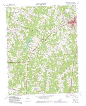
South Hill Topo Map Virginia
To zoom in, hover over the map of South Hill
USGS Topo Quad 36078f2 - 1:24,000 scale
| Topo Map Name: | South Hill |
| USGS Topo Quad ID: | 36078f2 |
| Print Size: | ca. 21 1/4" wide x 27" high |
| Southeast Coordinates: | 36.625° N latitude / 78.125° W longitude |
| Map Center Coordinates: | 36.6875° N latitude / 78.1875° W longitude |
| U.S. State: | VA |
| Filename: | o36078f2.jpg |
| Download Map JPG Image: | South Hill topo map 1:24,000 scale |
| Map Type: | Topographic |
| Topo Series: | 7.5´ |
| Map Scale: | 1:24,000 |
| Source of Map Images: | United States Geological Survey (USGS) |
| Alternate Map Versions: |
South Hill VA 1968, updated 1977 Download PDF Buy paper map South Hill VA 1968, updated 1981 Download PDF Buy paper map South Hill VA 2010 Download PDF Buy paper map South Hill VA 2013 Download PDF Buy paper map South Hill VA 2016 Download PDF Buy paper map |
1:24,000 Topo Quads surrounding South Hill
> Back to 36078e1 at 1:100,000 scale
> Back to 36078a1 at 1:250,000 scale
> Back to U.S. Topo Maps home
South Hill topo map: Gazetteer
South Hill: Airports
South Hill Airfield elevation 119m 390′South Hill: Dams
Copleys Dam elevation 108m 354′Jeffreys Number One Dam elevation 110m 360′
Jeffreys Number Two Dam elevation 103m 337′
Lake Gordons Dam elevation 75m 246′
Moores Dam elevation 82m 269′
South Hill: Parks
Mecklenburg Wayside elevation 90m 295′Parker Park elevation 117m 383′
Town Park elevation 122m 400′
South Hill: Populated Places
Big Fork elevation 99m 324′Busy Bee Corner elevation 121m 396′
Cedar Grove elevation 91m 298′
Dockery elevation 112m 367′
Invermay elevation 96m 314′
Lombardy Grove elevation 103m 337′
Radcliff elevation 101m 331′
Redlawn elevation 97m 318′
Smiths Crossroads elevation 113m 370′
South Hill elevation 137m 449′
Union Level elevation 127m 416′
South Hill: Post Offices
South Hill Post Office elevation 137m 449′South Hill: Reservoirs
Lake Gordon elevation 75m 246′Pine Lake elevation 106m 347′
South Hill: Streams
Dockery Creek elevation 62m 203′Little Miles Creek elevation 76m 249′
Rocky Branch elevation 78m 255′
South Hill digital topo map on disk
Buy this South Hill topo map showing relief, roads, GPS coordinates and other geographical features, as a high-resolution digital map file on DVD:
Western Virginia & Southern West Virginia
Buy digital topo maps: Western Virginia & Southern West Virginia


