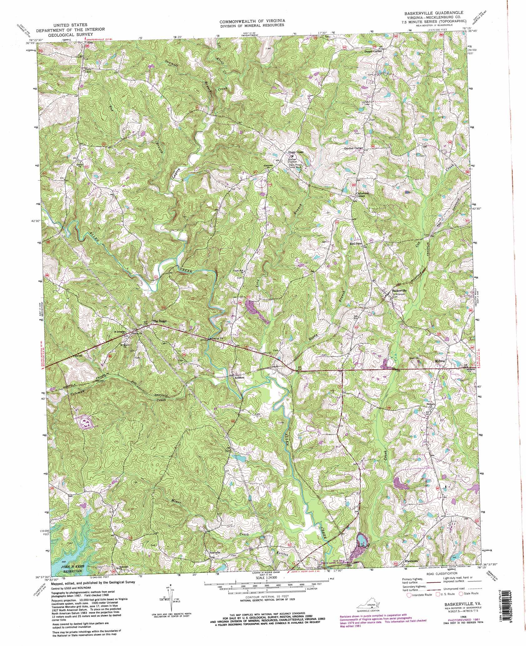
Baskerville Topo Map Virginia
To zoom in, hover over the map of Baskerville
USGS Topo Quad 36078f3 - 1:24,000 scale
| Topo Map Name: | Baskerville |
| USGS Topo Quad ID: | 36078f3 |
| Print Size: | ca. 21 1/4" wide x 27" high |
| Southeast Coordinates: | 36.625° N latitude / 78.25° W longitude |
| Map Center Coordinates: | 36.6875° N latitude / 78.3125° W longitude |
| U.S. State: | VA |
| Filename: | o36078f3.jpg |
| Download Map JPG Image: | Baskerville topo map 1:24,000 scale |
| Map Type: | Topographic |
| Topo Series: | 7.5´ |
| Map Scale: | 1:24,000 |
| Source of Map Images: | United States Geological Survey (USGS) |
| Alternate Map Versions: |
Baskerville VA 1968, updated 1972 Download PDF Buy paper map Baskerville VA 1968, updated 1977 Download PDF Buy paper map Baskerville VA 1968, updated 1981 Download PDF Buy paper map Baskerville VA 1968, updated 1981 Download PDF Buy paper map Baskerville VA 2010 Download PDF Buy paper map Baskerville VA 2013 Download PDF Buy paper map Baskerville VA 2016 Download PDF Buy paper map |
1:24,000 Topo Quads surrounding Baskerville
Drakes Branch |
Fort Mitchell |
Lunenburg |
Kenbridge West |
Kenbridge East |
Wylliesburg |
Chase City |
Wightman |
North View |
Forksville |
Clarksville North |
Boydton |
Baskerville |
South Hill |
La Crosse |
Clarksville South |
Tungsten |
John H Kerr Dam |
Bracey |
South Hill Se |
Stovall |
Townsville |
Middleburg |
Warrenton |
Macon |
> Back to 36078e1 at 1:100,000 scale
> Back to 36078a1 at 1:250,000 scale
> Back to U.S. Topo Maps home
Baskerville topo map: Gazetteer
Baskerville: Dams
Blalock Dam elevation 85m 278′Johnsons Dam elevation 73m 239′
Kidwell Dam elevation 78m 255′
Baskerville: Populated Places
Antlers elevation 75m 246′Baskerville elevation 98m 321′
Callahans Corner elevation 124m 406′
Dunns Corner elevation 146m 479′
Elamtown elevation 95m 311′
Gills elevation 106m 347′
Gordon Corner elevation 132m 433′
Midway elevation 115m 377′
Muck Cross elevation 116m 380′
Newmans elevation 103m 337′
Norvello elevation 91m 298′
The Ridge elevation 113m 370′
Baskerville: Reservoirs
Blalock Pond elevation 85m 278′Johnsons Pond elevation 73m 239′
Kidwell Pond elevation 78m 255′
Baskerville: Streams
Coleman Creek elevation 67m 219′Fox Branch elevation 73m 239′
Layton Creek elevation 69m 226′
Let Alone Creek elevation 81m 265′
Long Branch elevation 66m 216′
Mines Creek elevation 65m 213′
Pole Branch elevation 80m 262′
Reedy Branch elevation 65m 213′
Sawmill Branch elevation 77m 252′
Tapped Branch elevation 73m 239′
Baskerville digital topo map on disk
Buy this Baskerville topo map showing relief, roads, GPS coordinates and other geographical features, as a high-resolution digital map file on DVD:
Western Virginia & Southern West Virginia
Buy digital topo maps: Western Virginia & Southern West Virginia