South Boston Topo Map Virginia
To zoom in, hover over the map of South Boston
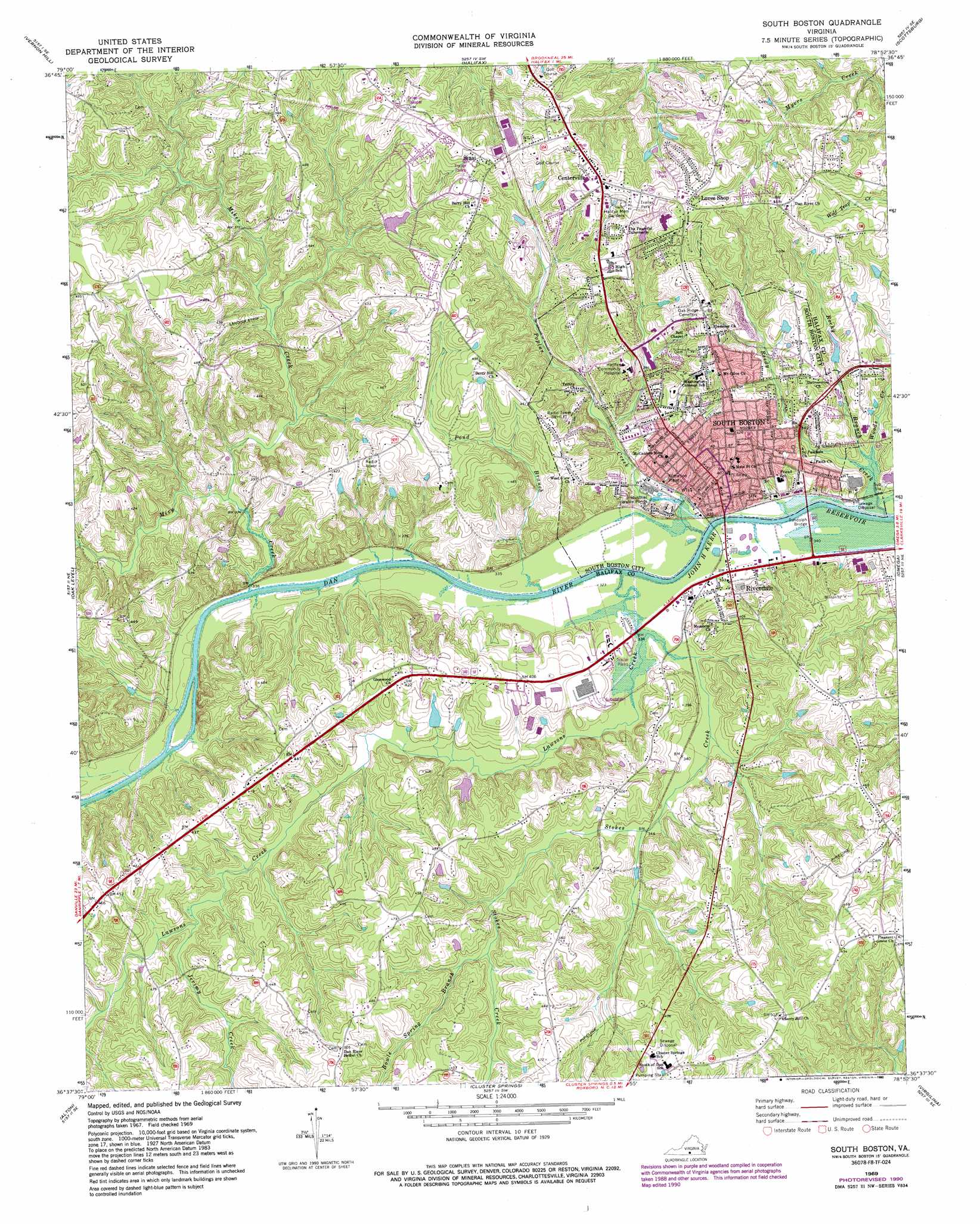
USGS Topo Quad 36078f8 - 1:24,000 scale
| Topo Map Name: | South Boston |
| USGS Topo Quad ID: | 36078f8 |
| Print Size: | ca. 21 1/4" wide x 27" high |
| Southeast Coordinates: | 36.625° N latitude / 78.875° W longitude |
| Map Center Coordinates: | 36.6875° N latitude / 78.9375° W longitude |
| U.S. State: | VA |
| Filename: | o36078f8.jpg |
| Download Map JPG Image: | South Boston topo map 1:24,000 scale |
| Map Type: | Topographic |
| Topo Series: | 7.5´ |
| Map Scale: | 1:24,000 |
| Source of Map Images: | United States Geological Survey (USGS) |
| Alternate Map Versions: |
South Boston VA 1969, updated 1972 Download PDF Buy paper map South Boston VA 1969, updated 1982 Download PDF Buy paper map South Boston VA 1969, updated 1990 Download PDF Buy paper map South Boston VA 2010 Download PDF Buy paper map South Boston VA 2013 Download PDF Buy paper map South Boston VA 2016 Download PDF Buy paper map |
1:24,000 Topo Quads surrounding South Boston
Mount Airy |
Republican Grove |
Nathalie |
Conner Lake |
Saxe |
Java |
Vernon Hill |
Halifax |
Scottsburg |
Clover |
Ingram |
Oak Level |
South Boston |
Omega |
Buffalo Springs |
Milton |
Alton |
Cluster Springs |
Virgilina |
Nelson |
Leasburg |
Olive Hill |
Roxboro |
Triple Springs |
Satterwhite |
> Back to 36078e1 at 1:100,000 scale
> Back to 36078a1 at 1:250,000 scale
> Back to U.S. Topo Maps home
South Boston topo map: Gazetteer
South Boston: Airports
South Boston Medical Heliport elevation 146m 479′South Boston: Bridges
Randolph Bridge elevation 97m 318′Tucker C Watkins Memorial Bridge elevation 97m 318′
South Boston: Dams
Cage Dam elevation 117m 383′Gilliam Dam elevation 104m 341′
McGhaulin and Mays Dam elevation 127m 416′
Powell Dam elevation 124m 406′
Williams Dam elevation 113m 370′
South Boston: Parks
Halifax County Fairgrounds elevation 118m 387′South Boston: Populated Places
Centerville elevation 160m 524′Fordland Estates elevation 152m 498′
Highland Hills elevation 146m 479′
Marsailles (historical) elevation 103m 337′
Oak Hill Estates elevation 152m 498′
Riverdale elevation 100m 328′
Sinai elevation 152m 498′
South Boston elevation 122m 400′
Westside Village elevation 150m 492′
Woodlawn Park elevation 146m 479′
South Boston: Post Offices
South Boston Post Office elevation 124m 406′South Boston: Reservoirs
Bruce Pond (historical) elevation 125m 410′Gilliam Pond elevation 104m 341′
South Boston: Streams
Bowle Spring Branch elevation 114m 374′Jerimy Creek elevation 111m 364′
Lawsons Creek elevation 97m 318′
Mikes Creek elevation 100m 328′
Miry Creek elevation 100m 328′
Pond Branch elevation 97m 318′
Poplar Creek elevation 97m 318′
Reedy Creek elevation 98m 321′
Rocky Branch elevation 99m 324′
Stokes Creek elevation 100m 328′
South Boston digital topo map on disk
Buy this South Boston topo map showing relief, roads, GPS coordinates and other geographical features, as a high-resolution digital map file on DVD:
Western Virginia & Southern West Virginia
Buy digital topo maps: Western Virginia & Southern West Virginia