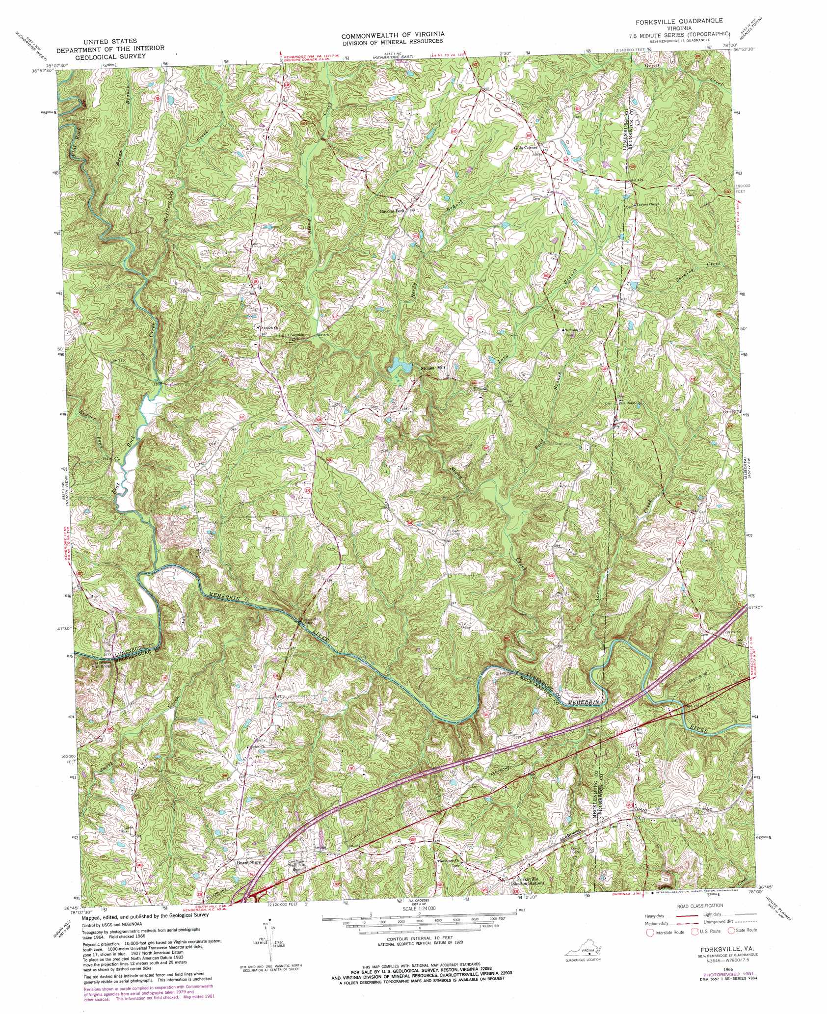
Forksville Topo Map Virginia
To zoom in, hover over the map of Forksville
USGS Topo Quad 36078g1 - 1:24,000 scale
| Topo Map Name: | Forksville |
| USGS Topo Quad ID: | 36078g1 |
| Print Size: | ca. 21 1/4" wide x 27" high |
| Southeast Coordinates: | 36.75° N latitude / 78° W longitude |
| Map Center Coordinates: | 36.8125° N latitude / 78.0625° W longitude |
| U.S. State: | VA |
| Filename: | o36078g1.jpg |
| Download Map JPG Image: | Forksville topo map 1:24,000 scale |
| Map Type: | Topographic |
| Topo Series: | 7.5´ |
| Map Scale: | 1:24,000 |
| Source of Map Images: | United States Geological Survey (USGS) |
| Alternate Map Versions: |
Forksville VA 1966, updated 1968 Download PDF Buy paper map Forksville VA 1966, updated 1982 Download PDF Buy paper map Forksville VA 2010 Download PDF Buy paper map Forksville VA 2013 Download PDF Buy paper map Forksville VA 2016 Download PDF Buy paper map |
1:24,000 Topo Quads surrounding Forksville
Meherrin |
Rubermont |
Blackstone West |
Blackstone East |
Darvills |
Lunenburg |
Kenbridge West |
Kenbridge East |
Danieltown |
Warfield |
Wightman |
North View |
Forksville |
Alberta |
Lawrenceville |
Baskerville |
South Hill |
La Crosse |
White Plains |
Powellton |
John H Kerr Dam |
Bracey |
South Hill Se |
Gasburg |
Valentines |
> Back to 36078e1 at 1:100,000 scale
> Back to 36078a1 at 1:250,000 scale
> Back to U.S. Topo Maps home
Forksville topo map: Gazetteer
Forksville: Bridges
Dix Bridge elevation 54m 177′Hawthorne High Bridge elevation 66m 216′
Union Mill Bridge elevation 58m 190′
Forksville: Crossings
Interchange 15 elevation 111m 364′Forksville: Populated Places
Bacons Fork elevation 119m 390′Forksville elevation 106m 347′
Gills Corner elevation 138m 452′
Lochleven elevation 137m 449′
Stones Mill elevation 81m 265′
Forksville: Post Offices
Lochleven Post Office (historical) elevation 137m 449′Forksville: Streams
Aaron Creek elevation 54m 177′Beaver Pond Creek elevation 63m 206′
Bold Branch elevation 64m 209′
Broad Branch elevation 72m 236′
Flat Rock Creek elevation 64m 209′
Kettlesticks Creek elevation 68m 223′
Long Branch elevation 70m 229′
Reedy Branch elevation 77m 252′
Smith Creek elevation 58m 190′
Stony Creek elevation 59m 193′
Forksville digital topo map on disk
Buy this Forksville topo map showing relief, roads, GPS coordinates and other geographical features, as a high-resolution digital map file on DVD:
Western Virginia & Southern West Virginia
Buy digital topo maps: Western Virginia & Southern West Virginia