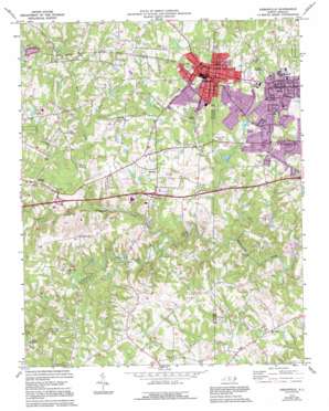
Gibsonville Topo Map North Carolina
To zoom in, hover over the map of Gibsonville
USGS Topo Quad 36079a5 - 1:24,000 scale
| Topo Map Name: | Gibsonville |
| USGS Topo Quad ID: | 36079a5 |
| Print Size: | ca. 21 1/4" wide x 27" high |
| Southeast Coordinates: | 36° N latitude / 79.5° W longitude |
| Map Center Coordinates: | 36.0625° N latitude / 79.5625° W longitude |
| U.S. State: | NC |
| Filename: | o36079a5.jpg |
| Download Map JPG Image: | Gibsonville topo map 1:24,000 scale |
| Map Type: | Topographic |
| Topo Series: | 7.5´ |
| Map Scale: | 1:24,000 |
| Source of Map Images: | United States Geological Survey (USGS) |
| Alternate Map Versions: |
Gibsonville NC 1970, updated 1973 Download PDF Buy paper map Gibsonville NC 1970, updated 1994 Download PDF Buy paper map Gibsonville NC 2010 Download PDF Buy paper map Gibsonville NC 2013 Download PDF Buy paper map Gibsonville NC 2016 Download PDF Buy paper map |
1:24,000 Topo Quads surrounding Gibsonville
> Back to 36079a1 at 1:100,000 scale
> Back to 36078a1 at 1:250,000 scale
> Back to U.S. Topo Maps home
Gibsonville topo map: Gazetteer
Gibsonville: Airports
Clayton Airpark elevation 200m 656′McLean Brothers Airport elevation 211m 692′
Gibsonville: Dams
Gerrards Lake Dam elevation 207m 679′McEwen Estate Dam elevation 190m 623′
Superior Stone Company Lake Dam elevation 212m 695′
Gibsonville: Parks
Beth Schmidt Park elevation 208m 682′Morgan Place Park elevation 209m 685′
Gibsonville: Populated Places
Country Club Acres elevation 207m 679′Deerfield elevation 197m 646′
Elon elevation 215m 705′
Gibsonville elevation 219m 718′
Glenwood Acres elevation 194m 636′
Mark View elevation 209m 685′
Random Hills elevation 195m 639′
Sedalia elevation 214m 702′
The Country elevation 183m 600′
Westbrook elevation 202m 662′
Westbrook Forest elevation 211m 692′
Westview elevation 212m 695′
Westview Terrace elevation 200m 656′
Whitsett elevation 207m 679′
Gibsonville: Reservoirs
Gerrards Lake elevation 207m 679′Superior Stone Company Lake elevation 212m 695′
Gibsonville: Streams
Beaver Creek elevation 169m 554′Little Alamance Creek elevation 168m 551′
Rock Creek elevation 168m 551′
Gibsonville digital topo map on disk
Buy this Gibsonville topo map showing relief, roads, GPS coordinates and other geographical features, as a high-resolution digital map file on DVD:
Western Virginia & Southern West Virginia
Buy digital topo maps: Western Virginia & Southern West Virginia


