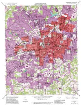
Greensboro Topo Map North Carolina
To zoom in, hover over the map of Greensboro
USGS Topo Quad 36079a7 - 1:24,000 scale
| Topo Map Name: | Greensboro |
| USGS Topo Quad ID: | 36079a7 |
| Print Size: | ca. 21 1/4" wide x 27" high |
| Southeast Coordinates: | 36° N latitude / 79.75° W longitude |
| Map Center Coordinates: | 36.0625° N latitude / 79.8125° W longitude |
| U.S. State: | NC |
| Filename: | o36079a7.jpg |
| Download Map JPG Image: | Greensboro topo map 1:24,000 scale |
| Map Type: | Topographic |
| Topo Series: | 7.5´ |
| Map Scale: | 1:24,000 |
| Source of Map Images: | United States Geological Survey (USGS) |
| Alternate Map Versions: |
Greensboro NC 1951, updated 1953 Download PDF Buy paper map Greensboro NC 1951, updated 1970 Download PDF Buy paper map Greensboro NC 1951, updated 1986 Download PDF Buy paper map Greensboro NC 1951, updated 1994 Download PDF Buy paper map Greensboro NC 1951, updated 1994 Download PDF Buy paper map Greensboro NC 1977, updated 1979 Download PDF Buy paper map Greensboro NC 1997, updated 2001 Download PDF Buy paper map Greensboro NC 2010 Download PDF Buy paper map Greensboro NC 2013 Download PDF Buy paper map Greensboro NC 2016 Download PDF Buy paper map |
1:24,000 Topo Quads surrounding Greensboro
> Back to 36079a1 at 1:100,000 scale
> Back to 36078a1 at 1:250,000 scale
> Back to U.S. Topo Maps home
Greensboro topo map: Gazetteer
Greensboro: Airports
Law Enforcement Center Airport elevation 245m 803′Greensboro: Dams
Benjamin Lake Dam elevation 255m 836′Buffalo Lake Dam elevation 233m 764′
Lake Hamilton Dam elevation 265m 869′
Lake Property Lake Dam elevation 236m 774′
Pegram Lake Dam elevation 221m 725′
Rounda Lake Dam elevation 231m 757′
Trospar Dam elevation 245m 803′
White Oak Lake Dam elevation 222m 728′
Greensboro: Lakes
White Oak Lake elevation 221m 725′Greensboro: Parks
Amber Park elevation 245m 803′Barber Park elevation 221m 725′
Brown Bark Park elevation 259m 849′
Dogwood Park elevation 230m 754′
Douglas Park elevation 244m 800′
Fisher Park elevation 235m 770′
Gillespie Park elevation 227m 744′
Greensboro Country Park elevation 266m 872′
Hamilton Lakes Park elevation 254m 833′
Hillsdale Park elevation 228m 748′
Lake Daniel Park elevation 227m 744′
Latham Park elevation 223m 731′
Lindley Park elevation 248m 813′
Rolling Park elevation 231m 757′
Shannon Hills Park elevation 237m 777′
Shannon Woods Park elevation 232m 761′
Spring Valley Park elevation 226m 741′
Starmount Park elevation 238m 780′
Tiffany Park elevation 252m 826′
Greensboro: Populated Places
Bluford Heights elevation 226m 741′British Woods elevation 267m 875′
Broadview elevation 247m 810′
Brookwood Gardens elevation 242m 793′
Carriage Hills elevation 274m 898′
Clinton Hills elevation 243m 797′
Cumberland elevation 241m 790′
Dellwood Park elevation 231m 757′
Dudley Heights elevation 236m 774′
East White Oak elevation 239m 784′
Edgeville elevation 231m 757′
Fairfield elevation 260m 853′
Fisher Park elevation 242m 793′
Forest Valley elevation 269m 882′
Friendly Acres elevation 270m 885′
Friendly Homes elevation 244m 800′
Garden Homes elevation 263m 862′
Glenwood elevation 253m 830′
Green Tree elevation 247m 810′
Green Valley elevation 255m 836′
Greenfield elevation 244m 800′
Greenhaven elevation 246m 807′
Greensboro elevation 252m 826′
Guilford Hills elevation 256m 839′
Hamilton Forest elevation 271m 889′
Hamilton Hills elevation 276m 905′
Hamilton Lakes elevation 250m 820′
Highland Park West elevation 265m 869′
Hillsdale Park elevation 238m 780′
Hunter Hills elevation 244m 800′
Irving Park elevation 239m 784′
Kirkwood elevation 250m 820′
Lake Daniel elevation 233m 764′
Latham Park elevation 246m 807′
Latham Town elevation 247m 810′
Lawndale Homes elevation 226m 741′
Lincoln Heights elevation 228m 748′
Lindley Park elevation 253m 830′
McAdoo Heights elevation 239m 784′
Meadowood Homes elevation 256m 839′
Nocho Park elevation 251m 823′
O Henry Oaks elevation 234m 767′
Oak Grove elevation 244m 800′
Oakwood elevation 261m 856′
Pennydale elevation 251m 823′
Piedmont Heights elevation 266m 872′
Pinecroft elevation 256m 839′
Pomona elevation 268m 879′
Proximity elevation 241m 790′
Random Woods elevation 249m 816′
Rankin elevation 245m 803′
Revolution elevation 236m 774′
Rocky Knoll elevation 236m 774′
Rolling Roads elevation 238m 780′
Scott Park elevation 241m 790′
Sedgefield Park elevation 258m 846′
Sedge-Town elevation 270m 885′
Shannon Hills elevation 255m 836′
Shannon Woods elevation 250m 820′
Smith Homes elevation 247m 810′
Southmont elevation 238m 780′
Spring Valley elevation 235m 770′
Starmount Forest elevation 251m 823′
Sunset Hills elevation 249m 816′
Terra Cotta elevation 269m 882′
The Pines elevation 248m 813′
Vandalia elevation 253m 830′
Warnersville elevation 253m 830′
Westbury elevation 246m 807′
Westerwood elevation 237m 777′
Westridge Heights elevation 276m 905′
Westwood elevation 268m 879′
White Oak elevation 237m 777′
Woodlea elevation 236m 774′
Woodlea Lakes elevation 246m 807′
Greensboro: Reservoirs
Benjamin Lake elevation 255m 836′Buffalo Lake elevation 233m 764′
Lake Euphemia elevation 255m 836′
Lake Hamilton elevation 265m 869′
Lake Property elevation 236m 774′
Pegram Lake elevation 221m 725′
Philadelphia Lake elevation 233m 764′
Revolution Mill Reservoir elevation 249m 816′
Rounda Lake Dam elevation 231m 757′
Trospar Lake elevation 245m 803′
White Oak Lake elevation 222m 728′
Greensboro: Streams
Mile Run Creek elevation 220m 721′Russells Run elevation 226m 741′
Ryan Creek elevation 224m 734′
Greensboro: Summits
Pisgah Hill elevation 281m 921′Greensboro digital topo map on disk
Buy this Greensboro topo map showing relief, roads, GPS coordinates and other geographical features, as a high-resolution digital map file on DVD:
Western Virginia & Southern West Virginia
Buy digital topo maps: Western Virginia & Southern West Virginia


