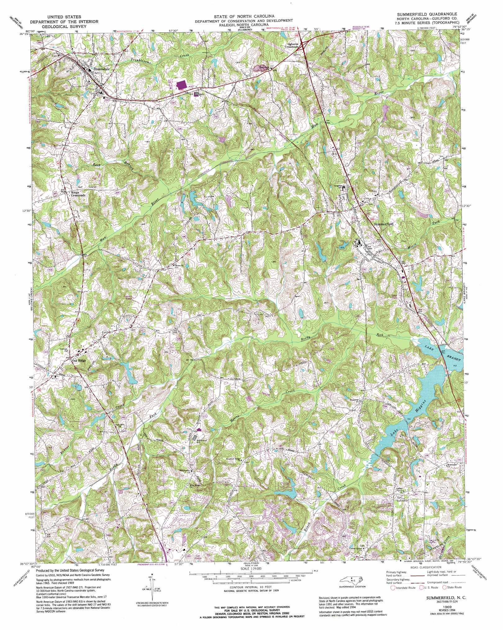
Summerfield Topo Map North Carolina
To zoom in, hover over the map of Summerfield
USGS Topo Quad 36079b8 - 1:24,000 scale
| Topo Map Name: | Summerfield |
| USGS Topo Quad ID: | 36079b8 |
| Print Size: | ca. 21 1/4" wide x 27" high |
| Southeast Coordinates: | 36.125° N latitude / 79.875° W longitude |
| Map Center Coordinates: | 36.1875° N latitude / 79.9375° W longitude |
| U.S. State: | NC |
| Filename: | o36079b8.jpg |
| Download Map JPG Image: | Summerfield topo map 1:24,000 scale |
| Map Type: | Topographic |
| Topo Series: | 7.5´ |
| Map Scale: | 1:24,000 |
| Source of Map Images: | United States Geological Survey (USGS) |
| Alternate Map Versions: |
Summerfield NC 1969, updated 1972 Download PDF Buy paper map Summerfield NC 1969, updated 1994 Download PDF Buy paper map Summerfield NC 2010 Download PDF Buy paper map Summerfield NC 2013 Download PDF Buy paper map Summerfield NC 2016 Download PDF Buy paper map |
1:24,000 Topo Quads surrounding Summerfield
Danbury |
Ayersville |
Mayodan |
Southwest Eden |
Southeast Eden |
Walnut Cove |
Belews Lake |
Ellisboro |
Bethany |
Reidsville |
Walkertown |
Belews Creek |
Summerfield |
Lake Brandt |
Browns Summit |
Winston-Salem East |
Kernersville |
Guilford |
Greensboro |
Mcleansville |
Midway |
High Point West |
High Point East |
Pleasant Garden |
Climax |
> Back to 36079a1 at 1:100,000 scale
> Back to 36078a1 at 1:250,000 scale
> Back to U.S. Topo Maps home
Summerfield topo map: Gazetteer
Summerfield: Dams
Bailes Old Mill Dam elevation 251m 823′Barricks Dam elevation 259m 849′
Cardinal Country Club Dam elevation 250m 820′
Carlson Farms Lake Dam elevation 256m 839′
Foglemans Lake Dam elevation 244m 800′
Foster Dam elevation 259m 849′
Hardin Lake Dam elevation 259m 849′
Henson Lake Dam elevation 246m 807′
Hobbs Lake Dam elevation 255m 836′
Honkers Hollow Dam elevation 276m 905′
Lake Higgins Dam elevation 232m 761′
Lambert Dam elevation 240m 787′
Lenio Dam elevation 260m 853′
Linville Dam elevation 266m 872′
Martin Lake Dam elevation 249m 816′
Ski Lake Dam elevation 246m 807′
Waynick Lake Dam elevation 244m 800′
Whitaker Lake Dam elevation 246m 807′
Wood Lake Dam elevation 243m 797′
Summerfield: Parks
Her-La-Co Park elevation 248m 813′Summerfield: Populated Places
Kings Crossroads elevation 290m 951′Oak Ridge elevation 286m 938′
Ogburns Crossroads elevation 278m 912′
Stokesdale elevation 291m 954′
Summerfield elevation 276m 905′
Summerfield: Reservoirs
Bailes Old Millpond elevation 251m 823′Barricks Lake elevation 259m 849′
Cardinal Country Club Lake elevation 250m 820′
Carlson Farms Lake elevation 256m 839′
Foglemans Lake elevation 244m 800′
Foster Lake elevation 259m 849′
Hardin Lake elevation 259m 849′
Henson Lake elevation 246m 807′
Hobbs Lake elevation 255m 836′
Honkers Hollow Lake elevation 276m 905′
Lake Higgins elevation 232m 761′
Lambert Lake elevation 240m 787′
Lenio Dam elevation 260m 853′
Linville Lake elevation 266m 872′
Martin Lake elevation 249m 816′
Ski Lake elevation 246m 807′
Waynick Lake elevation 244m 800′
Whitaker Lake elevation 246m 807′
Wood Lake elevation 243m 797′
Summerfield: Streams
Beaver Creek elevation 238m 780′Brush Creek elevation 226m 741′
Moores Creek elevation 229m 751′
Rock Branch elevation 237m 777′
Summerfield digital topo map on disk
Buy this Summerfield topo map showing relief, roads, GPS coordinates and other geographical features, as a high-resolution digital map file on DVD:
Western Virginia & Southern West Virginia
Buy digital topo maps: Western Virginia & Southern West Virginia