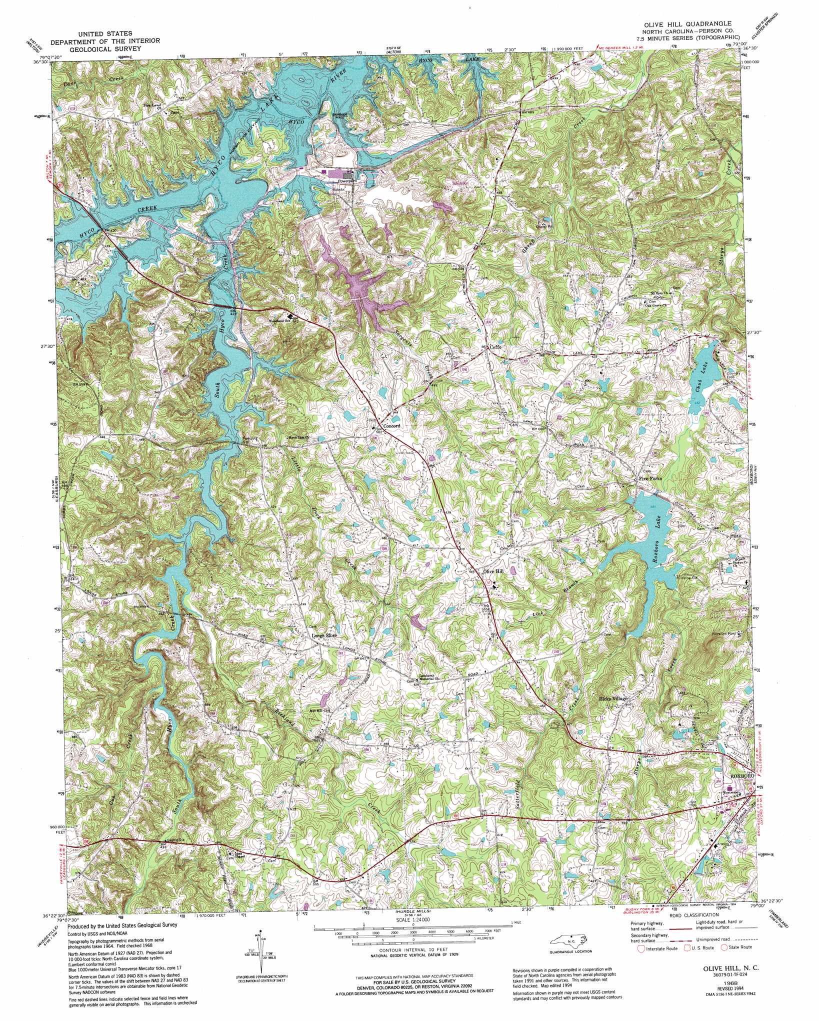
Olive Hill Topo Map North Carolina
To zoom in, hover over the map of Olive Hill
USGS Topo Quad 36079d1 - 1:24,000 scale
| Topo Map Name: | Olive Hill |
| USGS Topo Quad ID: | 36079d1 |
| Print Size: | ca. 21 1/4" wide x 27" high |
| Southeast Coordinates: | 36.375° N latitude / 79° W longitude |
| Map Center Coordinates: | 36.4375° N latitude / 79.0625° W longitude |
| U.S. State: | NC |
| Filename: | o36079d1.jpg |
| Download Map JPG Image: | Olive Hill topo map 1:24,000 scale |
| Map Type: | Topographic |
| Topo Series: | 7.5´ |
| Map Scale: | 1:24,000 |
| Source of Map Images: | United States Geological Survey (USGS) |
| Alternate Map Versions: |
Olive Hill NC 1968, updated 1994 Download PDF Buy paper map Olive Hill NC 2011 Download PDF Buy paper map Olive Hill NC 2013 Download PDF Buy paper map Olive Hill NC 2016 Download PDF Buy paper map |
1:24,000 Topo Quads surrounding Olive Hill
Blairs |
Ingram |
Oak Level |
South Boston |
Omega |
Ringgold |
Milton |
Alton |
Cluster Springs |
Virgilina |
Yanceyville |
Leasburg |
Olive Hill |
Roxboro |
Triple Springs |
Anderson |
Ridgeville |
Hurdle Mills |
Timberlake |
Moriah |
Burlington Ne |
Cedar Grove |
Caldwell |
Rougemont |
Lake Michie |
> Back to 36079a1 at 1:100,000 scale
> Back to 36078a1 at 1:250,000 scale
> Back to U.S. Topo Maps home
Olive Hill topo map: Gazetteer
Olive Hill: Bridges
Dunnaways Bridge (historical) elevation 125m 410′Olive Hill: Dams
C P and L Ash Pond elevation 126m 413′Chub Lake Dam elevation 140m 459′
Hedgepeth Pond Dam elevation 171m 561′
Roxboro Municipal Lake Dam elevation 144m 472′
Wagstaff Pond Dam elevation 151m 495′
Olive Hill: Populated Places
Ceffo elevation 177m 580′Chub Lake elevation 148m 485′
Concord elevation 175m 574′
Five Forks elevation 162m 531′
Hicks Village elevation 201m 659′
Lake View elevation 231m 757′
Longs Store elevation 194m 636′
Olive Hill elevation 203m 666′
Williamsville elevation 173m 567′
Olive Hill: Reservoirs
C P and L Ash Pond elevation 126m 413′Chub Lake elevation 140m 459′
Hedgepeth Pond elevation 171m 561′
Roxboro City Lake elevation 144m 472′
Roxboro Lake elevation 149m 488′
Wagstaff Pond elevation 151m 495′
Olive Hill: Streams
Cobbs Creek elevation 125m 410′Cub Creek elevation 125m 410′
Hyco Creek elevation 124m 406′
Lick Branch elevation 148m 485′
Little Duck Creek elevation 124m 406′
Richland Creek elevation 125m 410′
Sargents Creek elevation 125m 410′
Satterfield Creek elevation 148m 485′
South Hyco Creek elevation 124m 406′
Olive Hill digital topo map on disk
Buy this Olive Hill topo map showing relief, roads, GPS coordinates and other geographical features, as a high-resolution digital map file on DVD:
Western Virginia & Southern West Virginia
Buy digital topo maps: Western Virginia & Southern West Virginia