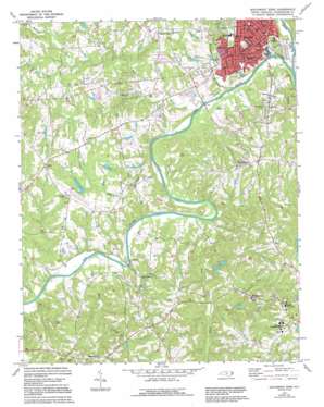
Southwest Eden Topo Map North Carolina
To zoom in, hover over the map of Southwest Eden
USGS Topo Quad 36079d7 - 1:24,000 scale
| Topo Map Name: | Southwest Eden |
| USGS Topo Quad ID: | 36079d7 |
| Print Size: | ca. 21 1/4" wide x 27" high |
| Southeast Coordinates: | 36.375° N latitude / 79.75° W longitude |
| Map Center Coordinates: | 36.4375° N latitude / 79.8125° W longitude |
| U.S. State: | NC |
| Filename: | o36079d7.jpg |
| Download Map JPG Image: | Southwest Eden topo map 1:24,000 scale |
| Map Type: | Topographic |
| Topo Series: | 7.5´ |
| Map Scale: | 1:24,000 |
| Source of Map Images: | United States Geological Survey (USGS) |
| Alternate Map Versions: |
Southwest Eden NC 1971, updated 1974 Download PDF Buy paper map Southwest Eden NC 1971, updated 1994 Download PDF Buy paper map Southwest Eden NC 2002, updated 2002 Download PDF Buy paper map Southwest Eden NC 2010 Download PDF Buy paper map Southwest Eden NC 2013 Download PDF Buy paper map Southwest Eden NC 2016 Download PDF Buy paper map |
1:24,000 Topo Quads surrounding Southwest Eden
> Back to 36079a1 at 1:100,000 scale
> Back to 36078a1 at 1:250,000 scale
> Back to U.S. Topo Maps home
Southwest Eden topo map: Gazetteer
Southwest Eden: Airports
Four Winds Farm Airport elevation 185m 606′Rockingham County Airport elevation 201m 659′
Shiloh Airport elevation 202m 662′
Southwest Eden: Bridges
Rockhouse Creek Bridge elevation 167m 547′Settles Bridge elevation 157m 515′
Southwest Eden: Crossings
Dead Timbers Ford elevation 157m 515′Southwest Eden: Dams
Medberrys Lake Dam elevation 193m 633′Smiths Lake Dam elevation 157m 515′
Tuttles Lake Dam elevation 155m 508′
Youngs Lake Dam elevation 213m 698′
Southwest Eden: Populated Places
Dan River elevation 201m 659′Eden elevation 181m 593′
Green Knolls elevation 170m 557′
Holly Hills elevation 180m 590′
Homestead elevation 181m 593′
Indian Hills elevation 175m 574′
Kirkwood elevation 229m 751′
Laurel Bluffs elevation 211m 692′
Meadowood elevation 188m 616′
Piney Fork elevation 227m 744′
Pleasantville elevation 234m 767′
Providence elevation 191m 626′
Ravenwood elevation 183m 600′
Reywin Acres elevation 167m 547′
Riverbend elevation 182m 597′
Shiloh elevation 235m 770′
Shiloh Acres elevation 210m 688′
Smith Acres elevation 182m 597′
Sunset Hills elevation 205m 672′
Wentworth elevation 224m 734′
West Holly Hills elevation 190m 623′
Whipporrwill Hills elevation 182m 597′
Whispering Pines elevation 186m 610′
Windwood elevation 185m 606′
Southwest Eden: Reservoirs
Medberrys Lake elevation 193m 633′Smiths Lake elevation 157m 515′
Tuttles Lake elevation 155m 508′
Youngs Lake elevation 213m 698′
Southwest Eden: Streams
Buffalo Creek elevation 151m 495′Massy Creek elevation 157m 515′
Matrimony Creek elevation 151m 495′
Roach Creek elevation 155m 508′
Rock House Creek elevation 155m 508′
Smith River elevation 150m 492′
Whetstone Creek elevation 153m 501′
Southwest Eden digital topo map on disk
Buy this Southwest Eden topo map showing relief, roads, GPS coordinates and other geographical features, as a high-resolution digital map file on DVD:
Western Virginia & Southern West Virginia
Buy digital topo maps: Western Virginia & Southern West Virginia


