Danville Topo Map Virginia
To zoom in, hover over the map of Danville
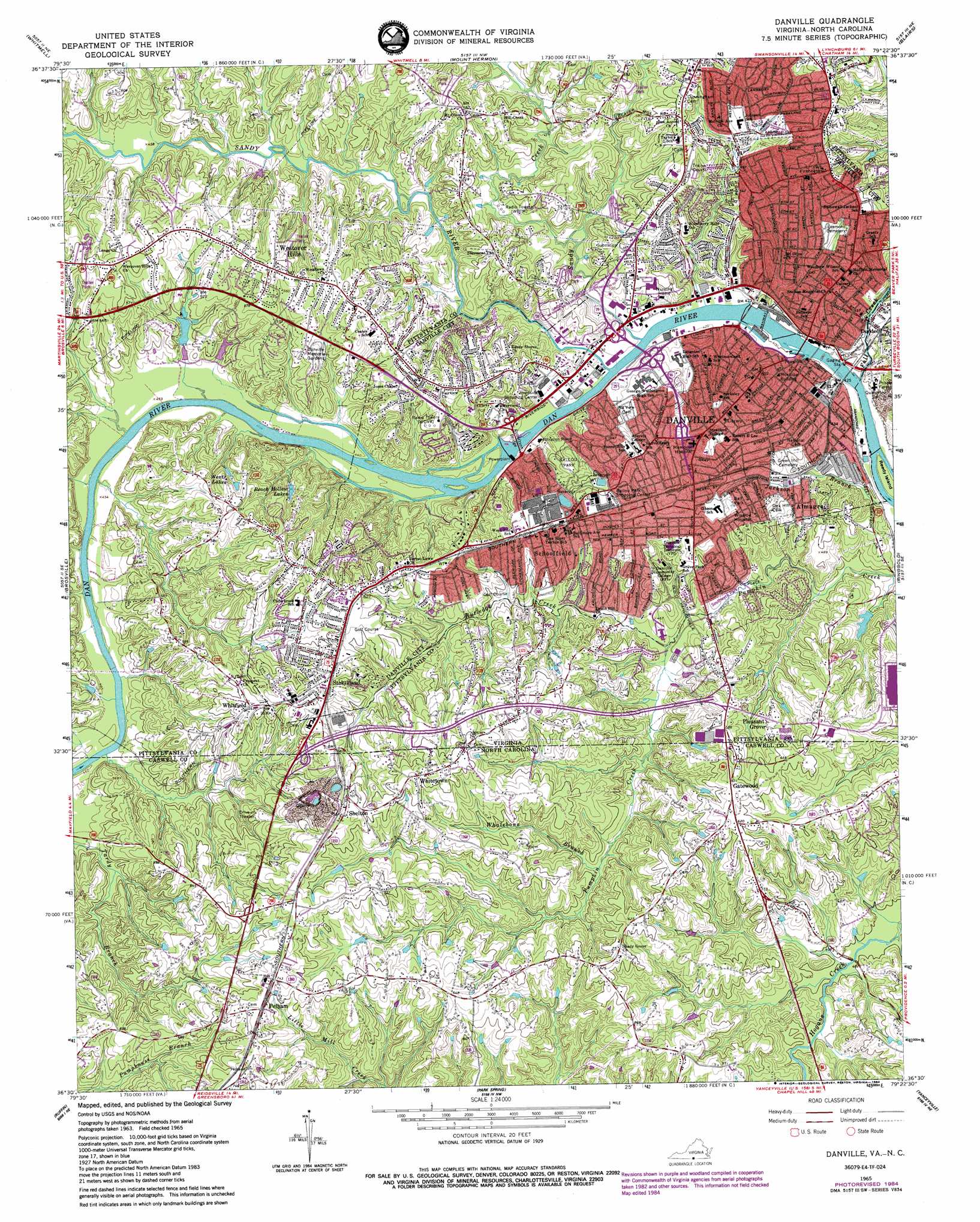
USGS Topo Quad 36079e4 - 1:24,000 scale
| Topo Map Name: | Danville |
| USGS Topo Quad ID: | 36079e4 |
| Print Size: | ca. 21 1/4" wide x 27" high |
| Southeast Coordinates: | 36.5° N latitude / 79.375° W longitude |
| Map Center Coordinates: | 36.5625° N latitude / 79.4375° W longitude |
| U.S. States: | VA, NC |
| Filename: | o36079e4.jpg |
| Download Map JPG Image: | Danville topo map 1:24,000 scale |
| Map Type: | Topographic |
| Topo Series: | 7.5´ |
| Map Scale: | 1:24,000 |
| Source of Map Images: | United States Geological Survey (USGS) |
| Alternate Map Versions: |
Danville VA 1964, updated 1967 Download PDF Buy paper map Danville VA 1964, updated 1981 Download PDF Buy paper map Danville VA 1965, updated 1966 Download PDF Buy paper map Danville VA 1965, updated 1971 Download PDF Buy paper map Danville VA 1965, updated 1978 Download PDF Buy paper map Danville VA 1965, updated 1984 Download PDF Buy paper map Danville VA 2011 Download PDF Buy paper map Danville VA 2013 Download PDF Buy paper map Danville VA 2016 Download PDF Buy paper map |
1:24,000 Topo Quads surrounding Danville
Mountain Valley |
Callands |
Chatham |
Spring Garden |
Java |
Axton |
Whitmell |
Mount Hermon |
Blairs |
Ingram |
Northeast Eden |
Brosville |
Danville |
Ringgold |
Milton |
Southeast Eden |
Ruffin |
Park Spring |
Yanceyville |
Leasburg |
Reidsville |
Williamsburg |
Cherry Grove |
Anderson |
Ridgeville |
> Back to 36079e1 at 1:100,000 scale
> Back to 36078a1 at 1:250,000 scale
> Back to U.S. Topo Maps home
Danville topo map: Gazetteer
Danville: Bridges
Main Street Bridge elevation 119m 390′Robertson Bridge elevation 125m 410′
Union Street Bridge elevation 122m 400′
Worsham Street Bridge elevation 119m 390′
Danville: Dams
Arey Dam elevation 149m 488′Boatwright Dam elevation 155m 508′
Boatwright Dam elevation 154m 505′
Riverside Dam elevation 119m 390′
Schoolfield Dam elevation 125m 410′
Danville: Islands
Reedy Island elevation 129m 423′Danville: Parks
Auctioneers Park elevation 127m 416′Ballou Park elevation 177m 580′
Camilla Williams Park elevation 129m 423′
Dan Daniel Memorial Park elevation 127m 416′
Danville Historic District elevation 159m 521′
Danville Tobacco Warehouse and Residential Historic District elevation 134m 439′
Fountain Park elevation 161m 528′
Green Street Park elevation 168m 551′
Monument Circle elevation 176m 577′
Reservoir Park elevation 195m 639′
Schoolfield Recreation Center elevation 194m 636′
Southwick Park elevation 131m 429′
Stonewall Jackson Park elevation 192m 629′
Danville: Populated Places
Almagro elevation 167m 547′Beverstone Park elevation 173m 567′
Birnam Wood elevation 163m 534′
Brentwood Park elevation 186m 610′
Cedar Park elevation 177m 580′
Country Club West elevation 181m 593′
Dan River (historical) elevation 143m 469′
Danville elevation 162m 531′
Danville Estates elevation 187m 613′
Donna Estates elevation 185m 606′
Druid Hills elevation 157m 515′
Dundee elevation 140m 459′
Edgewood elevation 190m 623′
Forest Hills elevation 165m 541′
Fox Hollow elevation 173m 567′
Gatewood elevation 197m 646′
Grove Park elevation 157m 515′
Miller Park elevation 183m 600′
Newton elevation 190m 623′
Oak Hills elevation 172m 564′
Pelham elevation 225m 738′
Pine Crest elevation 173m 567′
Pinetag elevation 193m 633′
Pleasant Grove elevation 177m 580′
Rutledge Creek Park elevation 181m 593′
Sandy Shores elevation 162m 531′
Schoolfield elevation 169m 554′
Shelton elevation 220m 721′
Sherwood Forest elevation 155m 508′
Springfield elevation 166m 544′
Starmount Forest elevation 170m 557′
Stokesland elevation 200m 656′
Surry Hills elevation 179m 587′
Tanglewydle elevation 182m 597′
Temple Terrace elevation 181m 593′
Wedgewood elevation 163m 534′
Westover Hills elevation 182m 597′
Whitetown elevation 230m 754′
Whitfield elevation 195m 639′
Windsor Heights elevation 162m 531′
Withers Park elevation 190m 623′
Woodbury Hills elevation 166m 544′
Wyndover Woods elevation 157m 515′
Danville: Post Offices
Danville Post Office elevation 169m 554′Danville: Reservoirs
Arey Lake elevation 149m 488′Beach Hollow Lakes elevation 168m 551′
Boatwright Pond elevation 155m 508′
Lake Heron elevation 148m 485′
Riverside Reservoir elevation 124m 406′
Schoolfield Reservoir elevation 125m 410′
Wentz Lakes elevation 172m 564′
Danville: Streams
Fall Creek elevation 119m 390′Jackson Branch elevation 114m 374′
Rutledge Creek elevation 134m 439′
Rutledy Creek elevation 132m 433′
Sandy Creek elevation 125m 410′
Sandy River elevation 125m 410′
Whalebone Branch elevation 148m 485′
Danville digital topo map on disk
Buy this Danville topo map showing relief, roads, GPS coordinates and other geographical features, as a high-resolution digital map file on DVD:
Western Virginia & Southern West Virginia
Buy digital topo maps: Western Virginia & Southern West Virginia