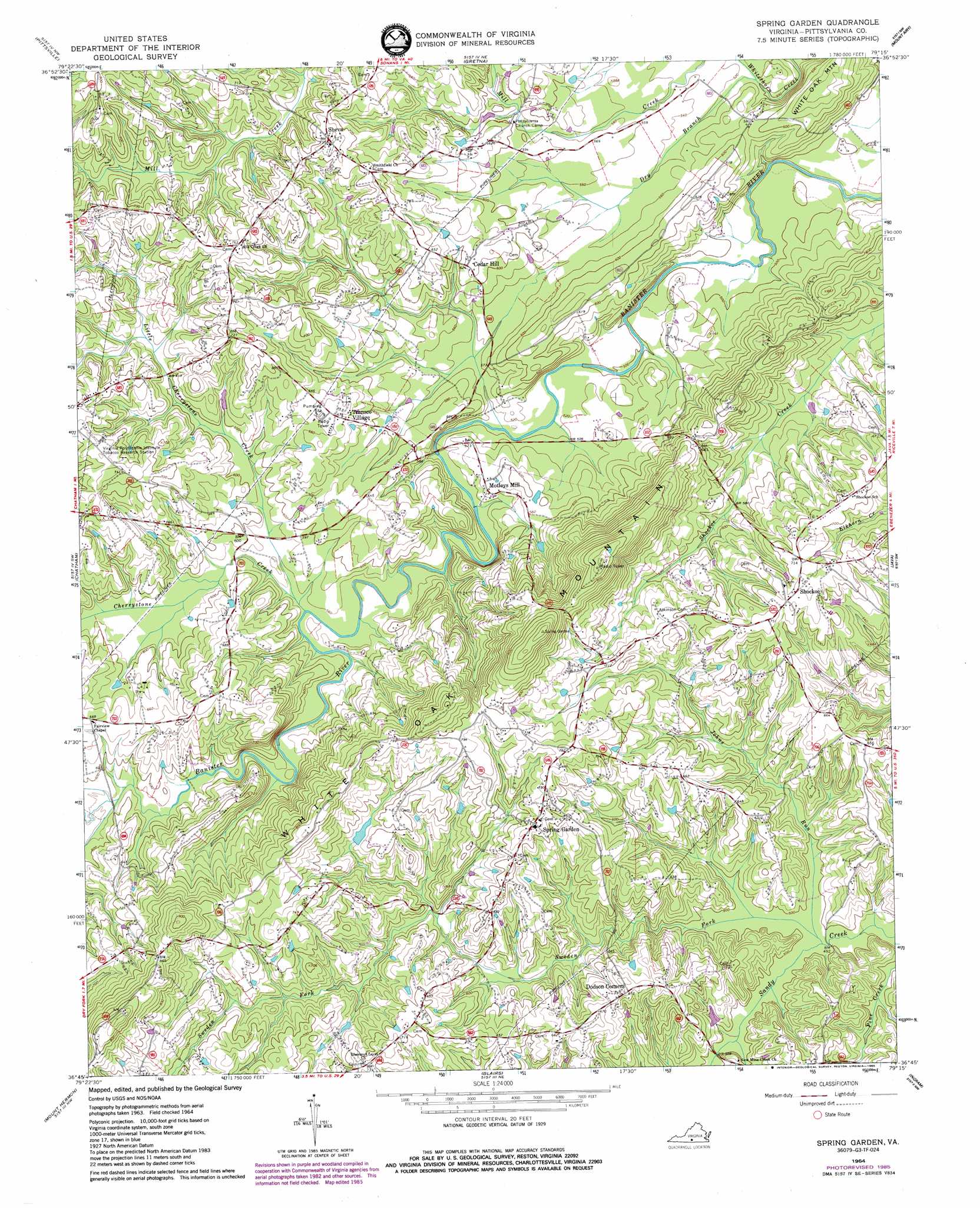
Spring Garden Topo Map Virginia
To zoom in, hover over the map of Spring Garden
USGS Topo Quad 36079g3 - 1:24,000 scale
| Topo Map Name: | Spring Garden |
| USGS Topo Quad ID: | 36079g3 |
| Print Size: | ca. 21 1/4" wide x 27" high |
| Southeast Coordinates: | 36.75° N latitude / 79.25° W longitude |
| Map Center Coordinates: | 36.8125° N latitude / 79.3125° W longitude |
| U.S. State: | VA |
| Filename: | o36079g3.jpg |
| Download Map JPG Image: | Spring Garden topo map 1:24,000 scale |
| Map Type: | Topographic |
| Topo Series: | 7.5´ |
| Map Scale: | 1:24,000 |
| Source of Map Images: | United States Geological Survey (USGS) |
| Alternate Map Versions: |
Spring Garden VA 1964, updated 1966 Download PDF Buy paper map Spring Garden VA 1964, updated 1980 Download PDF Buy paper map Spring Garden VA 1964, updated 1985 Download PDF Buy paper map Spring Garden VA 1964, updated 1985 Download PDF Buy paper map Spring Garden VA 2011 Download PDF Buy paper map Spring Garden VA 2013 Download PDF Buy paper map Spring Garden VA 2016 Download PDF Buy paper map |
1:24,000 Topo Quads surrounding Spring Garden
Smith Mountain Dam |
Leesville |
Altavista |
Straightstone |
Long Island |
Sandy Level |
Pittsville |
Gretna |
Mount Airy |
Republican Grove |
Callands |
Chatham |
Spring Garden |
Java |
Vernon Hill |
Whitmell |
Mount Hermon |
Blairs |
Ingram |
Oak Level |
Brosville |
Danville |
Ringgold |
Milton |
Alton |
> Back to 36079e1 at 1:100,000 scale
> Back to 36078a1 at 1:250,000 scale
> Back to U.S. Topo Maps home
Spring Garden topo map: Gazetteer
Spring Garden: Bridges
Clark Bridge elevation 157m 515′Robinson Bridge (historical) elevation 170m 557′
Spring Garden: Dams
C B Firth Dam elevation 178m 583′Hood Dam elevation 178m 583′
White Oak Mountain Dam elevation 200m 656′
Spring Garden: Parks
White Oak Mountain Wildlife Management Area elevation 187m 613′Spring Garden: Populated Places
Cedar Hill elevation 190m 623′Motleys Mill elevation 172m 564′
Sheva elevation 225m 738′
Shockoe elevation 222m 728′
Spring Garden elevation 227m 744′
Transco Village elevation 204m 669′
Spring Garden: Reservoirs
Hood Lake elevation 178m 583′White Oak Mountain Lake elevation 200m 656′
Spring Garden: Streams
Cherrystone Creek elevation 170m 557′Dry Branch elevation 155m 508′
Johns Run elevation 148m 485′
Little Cherrystone Creek elevation 170m 557′
Sweden Fork elevation 148m 485′
Spring Garden digital topo map on disk
Buy this Spring Garden topo map showing relief, roads, GPS coordinates and other geographical features, as a high-resolution digital map file on DVD:
Western Virginia & Southern West Virginia
Buy digital topo maps: Western Virginia & Southern West Virginia