Pittsville Topo Map Virginia
To zoom in, hover over the map of Pittsville
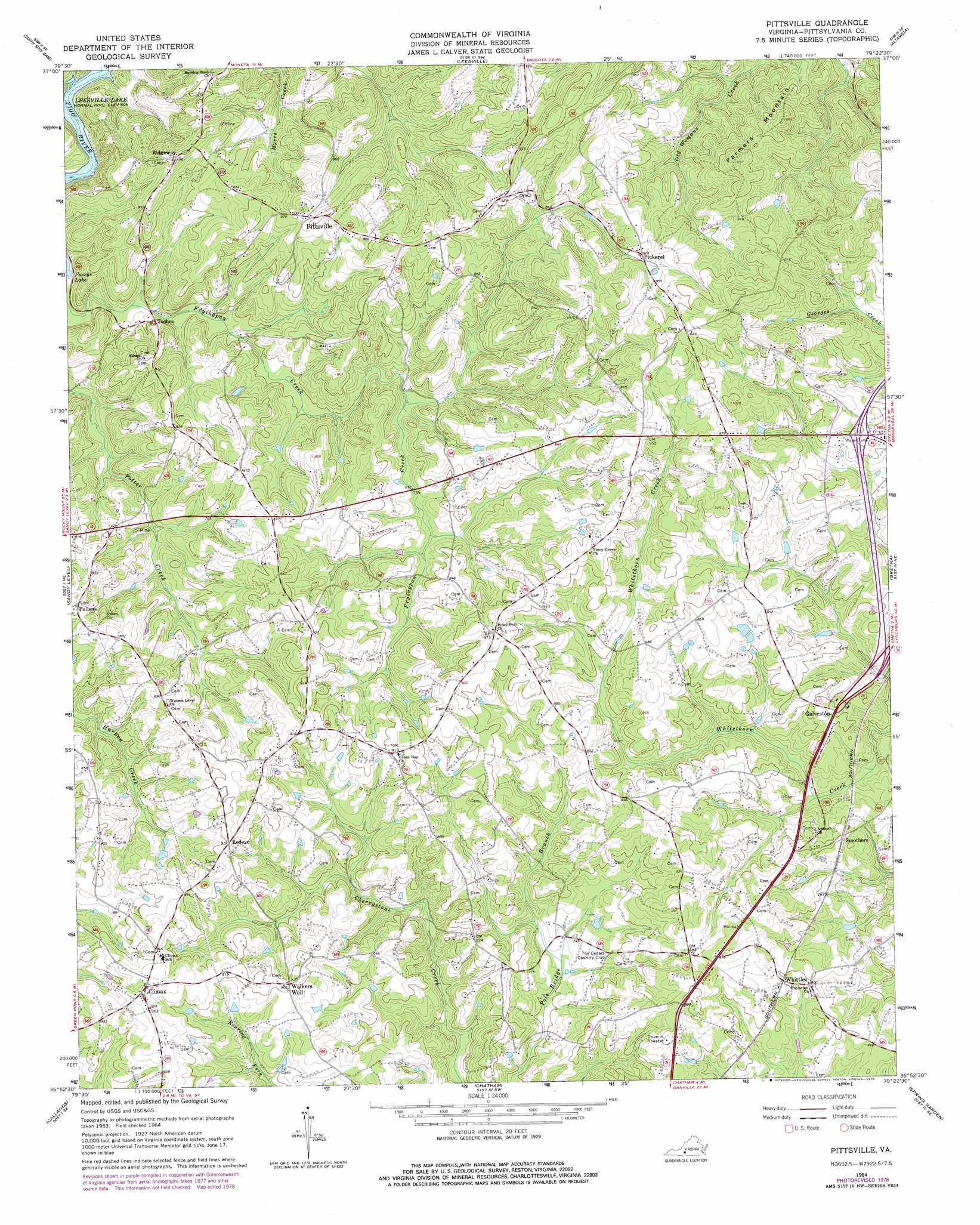
USGS Topo Quad 36079h4 - 1:24,000 scale
| Topo Map Name: | Pittsville |
| USGS Topo Quad ID: | 36079h4 |
| Print Size: | ca. 21 1/4" wide x 27" high |
| Southeast Coordinates: | 36.875° N latitude / 79.375° W longitude |
| Map Center Coordinates: | 36.9375° N latitude / 79.4375° W longitude |
| U.S. State: | VA |
| Filename: | o36079h4.jpg |
| Download Map JPG Image: | Pittsville topo map 1:24,000 scale |
| Map Type: | Topographic |
| Topo Series: | 7.5´ |
| Map Scale: | 1:24,000 |
| Source of Map Images: | United States Geological Survey (USGS) |
| Alternate Map Versions: |
Pittsville VA 1964, updated 1967 Download PDF Buy paper map Pittsville VA 1964, updated 1978 Download PDF Buy paper map Pittsville VA 2011 Download PDF Buy paper map Pittsville VA 2013 Download PDF Buy paper map Pittsville VA 2016 Download PDF Buy paper map |
1:24,000 Topo Quads surrounding Pittsville
Goodview |
Moneta |
Huddleston |
Lynch Station |
Castle Craig |
Moneta Sw |
Smith Mountain Dam |
Leesville |
Altavista |
Straightstone |
Penhook |
Sandy Level |
Pittsville |
Gretna |
Mount Airy |
Mountain Valley |
Callands |
Chatham |
Spring Garden |
Java |
Axton |
Whitmell |
Mount Hermon |
Blairs |
Ingram |
> Back to 36079e1 at 1:100,000 scale
> Back to 36078a1 at 1:250,000 scale
> Back to U.S. Topo Maps home
Pittsville topo map: Gazetteer
Pittsville: Dams
Shelhorse Dam elevation 251m 823′Pittsville: Mines
Bennett Mine elevation 262m 859′Thompsons Mine elevation 213m 698′
Pittsville: Populated Places
Climax elevation 293m 961′Farmers elevation 313m 1026′
Galveston elevation 245m 803′
Newton (historical) elevation 212m 695′
Pickerel elevation 282m 925′
Pittsville elevation 270m 885′
Pullens elevation 264m 866′
Redeye elevation 276m 905′
Ridgeway elevation 272m 892′
Smothers elevation 237m 777′
Toshes elevation 215m 705′
Whittles elevation 244m 800′
Pittsville: Summits
Farmers Mountain elevation 333m 1092′Pittsville digital topo map on disk
Buy this Pittsville topo map showing relief, roads, GPS coordinates and other geographical features, as a high-resolution digital map file on DVD:
Western Virginia & Southern West Virginia
Buy digital topo maps: Western Virginia & Southern West Virginia