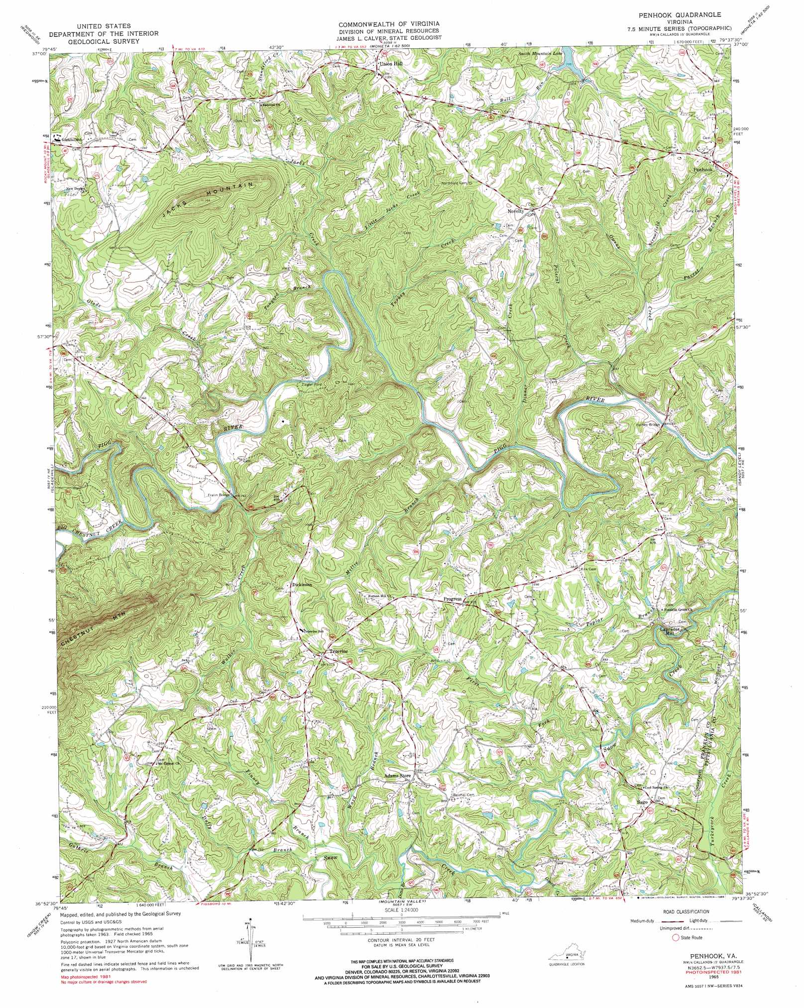
Penhook Topo Map Virginia
To zoom in, hover over the map of Penhook
USGS Topo Quad 36079h6 - 1:24,000 scale
| Topo Map Name: | Penhook |
| USGS Topo Quad ID: | 36079h6 |
| Print Size: | ca. 21 1/4" wide x 27" high |
| Southeast Coordinates: | 36.875° N latitude / 79.625° W longitude |
| Map Center Coordinates: | 36.9375° N latitude / 79.6875° W longitude |
| U.S. State: | VA |
| Filename: | o36079h6.jpg |
| Download Map JPG Image: | Penhook topo map 1:24,000 scale |
| Map Type: | Topographic |
| Topo Series: | 7.5´ |
| Map Scale: | 1:24,000 |
| Source of Map Images: | United States Geological Survey (USGS) |
| Alternate Map Versions: |
Penhook VA 1965, updated 1966 Download PDF Buy paper map Penhook VA 1965, updated 1985 Download PDF Buy paper map Penhook VA 2011 Download PDF Buy paper map Penhook VA 2013 Download PDF Buy paper map Penhook VA 2016 Download PDF Buy paper map |
1:24,000 Topo Quads surrounding Penhook
Garden City |
Hardy |
Goodview |
Moneta |
Huddleston |
Boones Mill |
Redwood |
Moneta Sw |
Smith Mountain Dam |
Leesville |
Rocky Mount |
Gladehill |
Penhook |
Sandy Level |
Pittsville |
Bassett |
Snow Creek |
Mountain Valley |
Callands |
Chatham |
Martinsville West |
Martinsville East |
Axton |
Whitmell |
Mount Hermon |
> Back to 36079e1 at 1:100,000 scale
> Back to 36078a1 at 1:250,000 scale
> Back to U.S. Topo Maps home
Penhook topo map: Gazetteer
Penhook: Bridges
Fralin Bridge elevation 228m 748′Haines Bridge elevation 206m 675′
Penhook: Crossings
Edwards Ford elevation 206m 675′Pearson Ford elevation 211m 692′
Ziegler Ford elevation 219m 718′
Penhook: Populated Places
Dickinson elevation 295m 967′Laprades Mill elevation 207m 679′
Peckerwood Level elevation 266m 872′
Penhook elevation 299m 980′
Progress elevation 282m 925′
Sago elevation 270m 885′
Penhook: Streams
Big Chestnut Creek elevation 228m 748′Dinner Creek elevation 210m 688′
Ditto Branch elevation 228m 748′
Duffy Branch elevation 231m 757′
Finney Branch elevation 230m 754′
First Fork elevation 219m 718′
Glade Creek elevation 222m 728′
Gourd Creek elevation 224m 734′
Jacks Creek elevation 219m 718′
Little Jacks Creek elevation 221m 725′
Millie Branch elevation 211m 692′
Owens Creek elevation 206m 675′
Parrot Branch elevation 206m 675′
Polecat Creek elevation 216m 708′
Poplar Branch elevation 207m 679′
Strawfield Creek elevation 229m 751′
Tanyard Branch elevation 219m 718′
Turkey Creek elevation 217m 711′
Walker Creek elevation 223m 731′
Ward Branch elevation 231m 757′
Penhook: Summits
Jacks Mountain elevation 406m 1332′Penhook digital topo map on disk
Buy this Penhook topo map showing relief, roads, GPS coordinates and other geographical features, as a high-resolution digital map file on DVD:
Western Virginia & Southern West Virginia
Buy digital topo maps: Western Virginia & Southern West Virginia