Osbornville Topo Map North Carolina
To zoom in, hover over the map of Osbornville
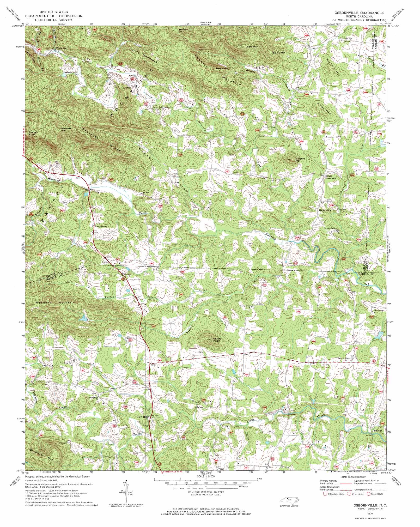
USGS Topo Quad 36080a8 - 1:24,000 scale
| Topo Map Name: | Osbornville |
| USGS Topo Quad ID: | 36080a8 |
| Print Size: | ca. 21 1/4" wide x 27" high |
| Southeast Coordinates: | 36° N latitude / 80.875° W longitude |
| Map Center Coordinates: | 36.0625° N latitude / 80.9375° W longitude |
| U.S. State: | NC |
| Filename: | o36080a8.jpg |
| Download Map JPG Image: | Osbornville topo map 1:24,000 scale |
| Map Type: | Topographic |
| Topo Series: | 7.5´ |
| Map Scale: | 1:24,000 |
| Source of Map Images: | United States Geological Survey (USGS) |
| Alternate Map Versions: |
Osbornville NC 1997, updated 2000 Download PDF Buy paper map Osbornville NC 2010 Download PDF Buy paper map Osbornville NC 2013 Download PDF Buy paper map Osbornville NC 2016 Download PDF Buy paper map |
1:24,000 Topo Quads surrounding Osbornville
Mcgrady |
Traphill |
Thurmond |
Elkin North |
Copeland |
Wilkesboro |
Roaring River |
Ronda |
Elkin South |
Yadkinville |
Moravian Falls |
Gilreath |
Osbornville |
Brooks Crossroads |
Lone Hickory |
Taylorsville |
Hiddenite |
Central |
Harmony |
Calahaln |
Millersville |
Stony Point |
Statesville West |
Statesville East |
Cool Springs |
> Back to 36080a1 at 1:100,000 scale
> Back to 36080a1 at 1:250,000 scale
> Back to U.S. Topo Maps home
Osbornville topo map: Gazetteer
Osbornville: Dams
Cass Dam elevation 301m 987′Johnson Dam elevation 367m 1204′
Mathis Dam elevation 449m 1473′
Osbornville: Populated Places
Jennings elevation 290m 951′Lovelace (historical) elevation 311m 1020′
New Castle elevation 332m 1089′
New Hope elevation 309m 1013′
Osbornville elevation 326m 1069′
Somers Crossroads elevation 333m 1092′
Windy Gap elevation 363m 1190′
Zimmerman (historical) elevation 294m 964′
Zion (historical) elevation 303m 994′
Osbornville: Reservoirs
Cass Fishing Lake elevation 301m 987′Mathis Lake elevation 449m 1473′
Noname elevation 367m 1204′
Osbornville: Ridges
Prevette Ridge elevation 454m 1489′Osbornville: Streams
Bear Branch elevation 373m 1223′Brushy Creek elevation 268m 879′
Bussels Creek elevation 295m 967′
Clercy Branch elevation 360m 1181′
Dishmon Creek elevation 322m 1056′
Dugger Creek elevation 297m 974′
Little Hunting Creek elevation 276m 905′
Osborn Creek elevation 270m 885′
Pasture Bottom Creek elevation 301m 987′
Sam Branch elevation 375m 1230′
Osbornville: Summits
Bailey Mountain elevation 496m 1627′Bald Mountain elevation 534m 1751′
Bear Mountain elevation 499m 1637′
Bee Knob elevation 515m 1689′
Fitches Knob elevation 564m 1850′
Grassy Knob elevation 450m 1476′
Harris Mountain elevation 491m 1610′
Hickory Mountain elevation 412m 1351′
Nesbert Hill elevation 568m 1863′
Piney Mountain elevation 410m 1345′
Redmond Mountain elevation 517m 1696′
Ringfire Mountain elevation 424m 1391′
Roberts Mountain elevation 517m 1696′
Shumaker Mountain elevation 516m 1692′
Wallace Mountain elevation 571m 1873′
Osbornville: Valleys
Cooter Hollow elevation 289m 948′Osbornville digital topo map on disk
Buy this Osbornville topo map showing relief, roads, GPS coordinates and other geographical features, as a high-resolution digital map file on DVD:
Western Virginia & Southern West Virginia
Buy digital topo maps: Western Virginia & Southern West Virginia