Dobson Topo Map North Carolina
To zoom in, hover over the map of Dobson
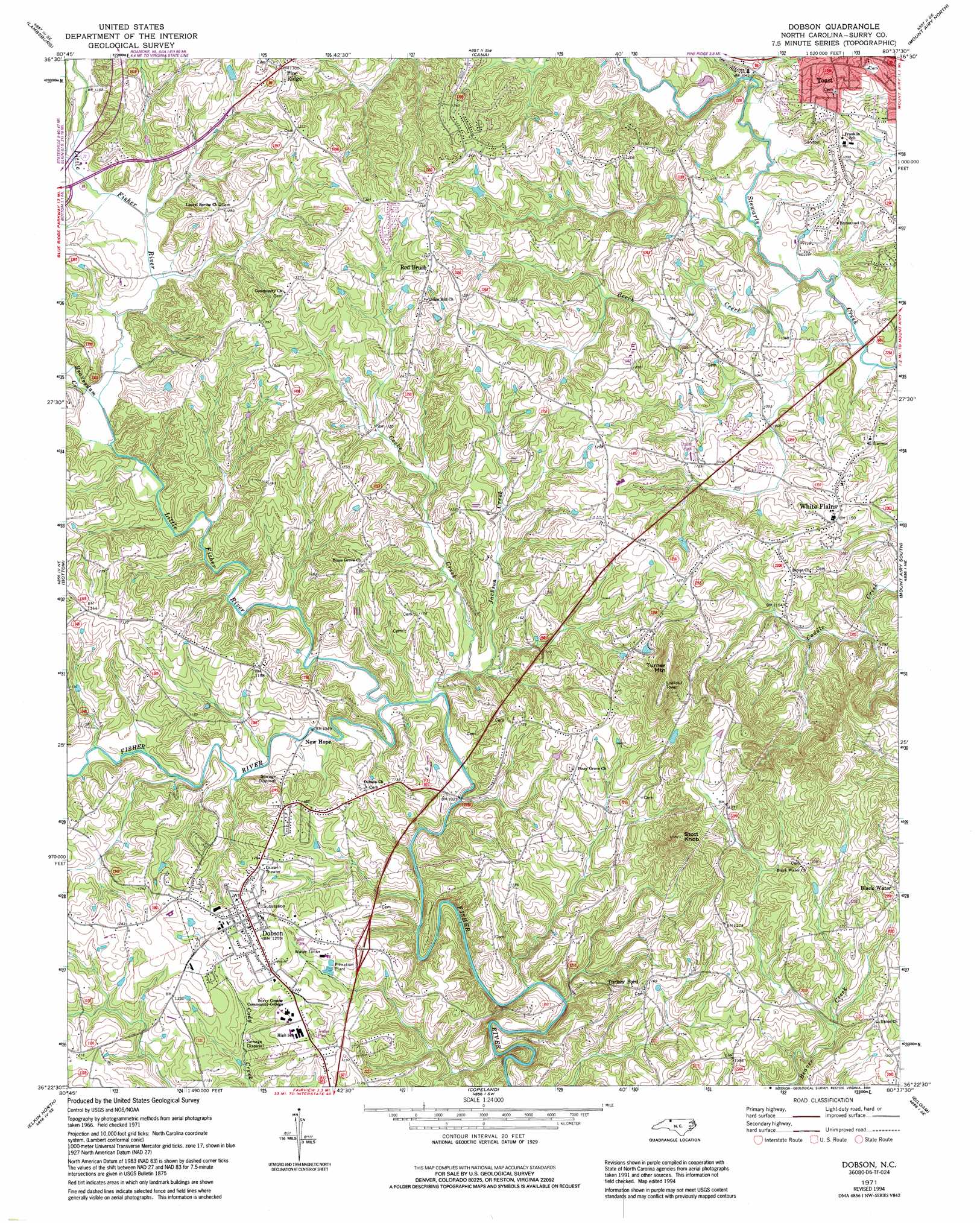
USGS Topo Quad 36080d6 - 1:24,000 scale
| Topo Map Name: | Dobson |
| USGS Topo Quad ID: | 36080d6 |
| Print Size: | ca. 21 1/4" wide x 27" high |
| Southeast Coordinates: | 36.375° N latitude / 80.625° W longitude |
| Map Center Coordinates: | 36.4375° N latitude / 80.6875° W longitude |
| U.S. State: | NC |
| Filename: | o36080d6.jpg |
| Download Map JPG Image: | Dobson topo map 1:24,000 scale |
| Map Type: | Topographic |
| Topo Series: | 7.5´ |
| Map Scale: | 1:24,000 |
| Source of Map Images: | United States Geological Survey (USGS) |
| Alternate Map Versions: |
Dobson NC 1971, updated 1973 Download PDF Buy paper map Dobson NC 1971, updated 1973 Download PDF Buy paper map Dobson NC 1971, updated 1994 Download PDF Buy paper map Dobson NC 1976, updated 1979 Download PDF Buy paper map Dobson NC 2010 Download PDF Buy paper map Dobson NC 2013 Download PDF Buy paper map Dobson NC 2016 Download PDF Buy paper map |
1:24,000 Topo Quads surrounding Dobson
Galax |
Woodlawn |
Fancy Gap |
Laurel Fork |
Meadows Of Dan |
Cumberland Knob |
Lambsburg |
Cana |
Mount Airy North |
Claudville |
Roaring Gap |
Bottom |
Dobson |
Mount Airy South |
Pilot Mountain |
Thurmond |
Elkin North |
Copeland |
Siloam |
Pinnacle |
Ronda |
Elkin South |
Yadkinville |
East Bend |
Vienna |
> Back to 36080a1 at 1:100,000 scale
> Back to 36080a1 at 1:250,000 scale
> Back to U.S. Topo Maps home
Dobson topo map: Gazetteer
Dobson: Dams
Doggett Lake Dam elevation 337m 1105′Hawks Lake Dam elevation 381m 1250′
Dobson: Parks
Bunker Homesite elevation 352m 1154′Reeves-Freeman House elevation 378m 1240′
Dobson: Populated Places
Dobson elevation 383m 1256′Franklin elevation 343m 1125′
Holly View Forest-Highland Park elevation 328m 1076′
New Hope elevation 326m 1069′
Pine Ridge elevation 395m 1295′
Red Brush elevation 410m 1345′
Turkey Ford elevation 355m 1164′
White Plains elevation 343m 1125′
Dobson: Reservoirs
Doggett Lake elevation 337m 1105′Hawks Lake elevation 381m 1250′
Dobson: Streams
Beaverdam Creek elevation 329m 1079′Beech Creek elevation 306m 1003′
Burkes Creek elevation 302m 990′
Cooks Creek elevation 310m 1017′
Horns Creek elevation 296m 971′
Jackson Creek elevation 310m 1017′
Little Fisher River elevation 307m 1007′
Ring Creek elevation 356m 1167′
Ross Creek elevation 322m 1056′
Turners Creek elevation 308m 1010′
Dobson: Summits
Stott Knob elevation 478m 1568′Turner Mountain elevation 484m 1587′
Dobson digital topo map on disk
Buy this Dobson topo map showing relief, roads, GPS coordinates and other geographical features, as a high-resolution digital map file on DVD:
Western Virginia & Southern West Virginia
Buy digital topo maps: Western Virginia & Southern West Virginia