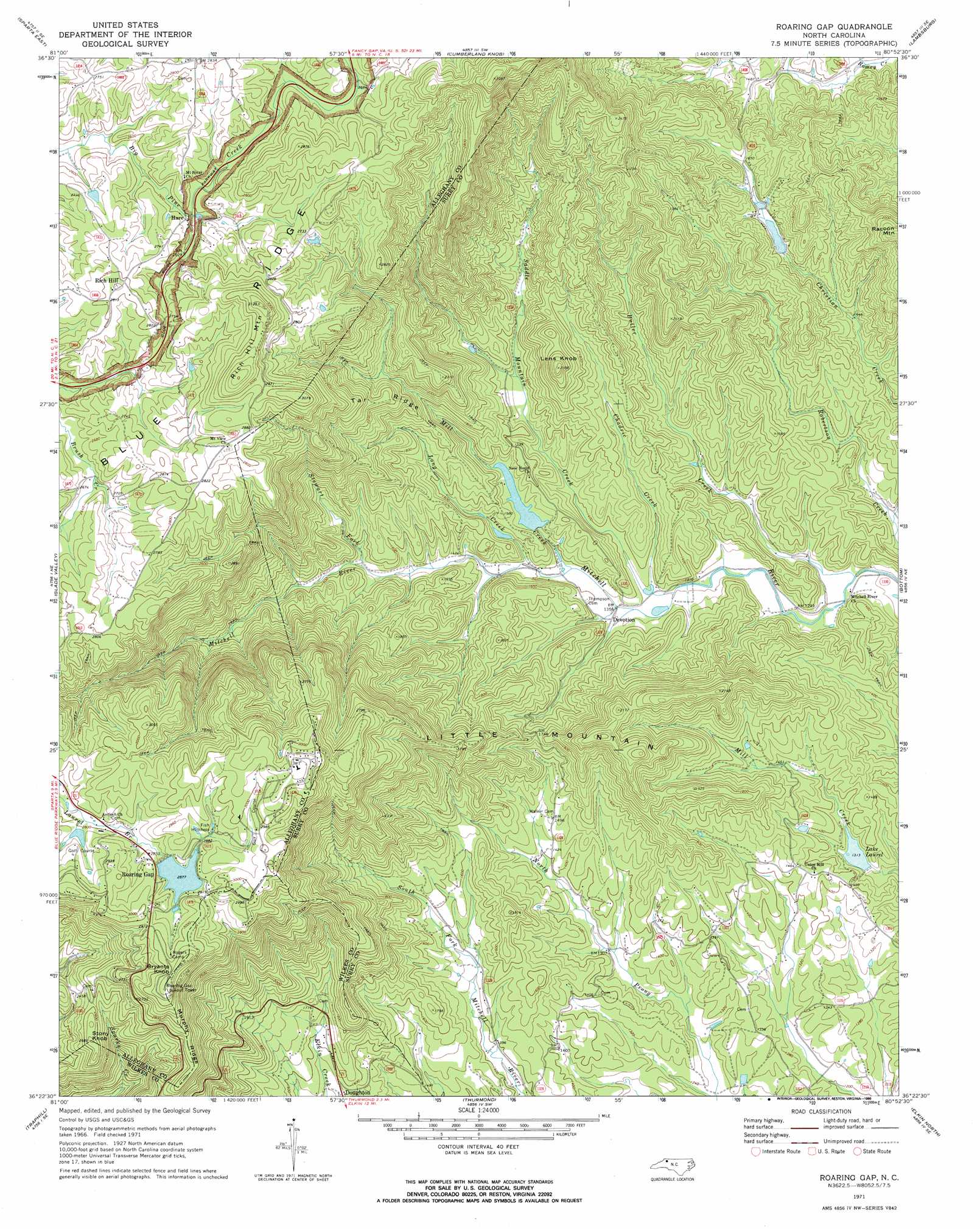
Roaring Gap Topo Map North Carolina
To zoom in, hover over the map of Roaring Gap
USGS Topo Quad 36080d8 - 1:24,000 scale
| Topo Map Name: | Roaring Gap |
| USGS Topo Quad ID: | 36080d8 |
| Print Size: | ca. 21 1/4" wide x 27" high |
| Southeast Coordinates: | 36.375° N latitude / 80.875° W longitude |
| Map Center Coordinates: | 36.4375° N latitude / 80.9375° W longitude |
| U.S. State: | NC |
| Filename: | o36080d8.jpg |
| Download Map JPG Image: | Roaring Gap topo map 1:24,000 scale |
| Map Type: | Topographic |
| Topo Series: | 7.5´ |
| Map Scale: | 1:24,000 |
| Source of Map Images: | United States Geological Survey (USGS) |
| Alternate Map Versions: |
Roaring Gap NC 1971, updated 1973 Download PDF Buy paper map Roaring Gap NC 1971, updated 1990 Download PDF Buy paper map Roaring Gap NC 1997, updated 2000 Download PDF Buy paper map Roaring Gap NC 2010 Download PDF Buy paper map Roaring Gap NC 2013 Download PDF Buy paper map Roaring Gap NC 2016 Download PDF Buy paper map |
1:24,000 Topo Quads surrounding Roaring Gap
Elk Creek |
Brierpatch Mountain |
Galax |
Woodlawn |
Fancy Gap |
Sparta West |
Sparta East |
Cumberland Knob |
Lambsburg |
Cana |
Whitehead |
Glade Valley |
Roaring Gap |
Bottom |
Dobson |
Mcgrady |
Traphill |
Thurmond |
Elkin North |
Copeland |
Wilkesboro |
Roaring River |
Ronda |
Elkin South |
Yadkinville |
> Back to 36080a1 at 1:100,000 scale
> Back to 36080a1 at 1:250,000 scale
> Back to U.S. Topo Maps home
Roaring Gap topo map: Gazetteer
Roaring Gap: Dams
D R Stone Dam elevation 811m 2660′High Meadows Dam elevation 886m 2906′
Lake Laurel Dam elevation 448m 1469′
Low Gap Wildlife Club Dam elevation 494m 1620′
Reynolds Lake Dam elevation 485m 1591′
Roaring Gap Lake Dam elevation 878m 2880′
Royall Lake Dam elevation 431m 1414′
Roaring Gap: Gaps
Roaring Gap elevation 885m 2903′Roaring Gap: Populated Places
Devotion elevation 416m 1364′Hare elevation 793m 2601′
High Meadows Estates elevation 907m 2975′
New Home (historical) elevation 493m 1617′
Rich Hill elevation 861m 2824′
Roaring Gap elevation 877m 2877′
Union Hill elevation 445m 1459′
Roaring Gap: Reservoirs
High Meadows Lake elevation 886m 2906′Lake Laurel elevation 400m 1312′
Lake Laurel elevation 448m 1469′
Lake Louise elevation 878m 2880′
Low Gap Wildlife Pond elevation 494m 1620′
Noname elevation 811m 2660′
Reynolds Lake elevation 485m 1591′
Royall Lake elevation 431m 1414′
Roaring Gap: Ridges
Murphy Ridge elevation 822m 2696′Tar Ridge elevation 692m 2270′
Roaring Gap: Streams
Butler Creek elevation 379m 1243′Chadric Creek elevation 409m 1341′
Long Creek elevation 426m 1397′
Mill Creek elevation 420m 1377′
Robertson Creek elevation 385m 1263′
Saddle Mountain Creek elevation 402m 1318′
Stewart Fork elevation 465m 1525′
Thompsons Branch elevation 402m 1318′
Williams Creek elevation 402m 1318′
Roaring Gap: Summits
Bryants Knob elevation 955m 3133′Lens Knob elevation 663m 2175′
Little Mountain elevation 960m 3149′
Racoon Mountain elevation 655m 2148′
Rich Hill Mountain elevation 971m 3185′
Stony Knob elevation 816m 2677′
Roaring Gap digital topo map on disk
Buy this Roaring Gap topo map showing relief, roads, GPS coordinates and other geographical features, as a high-resolution digital map file on DVD:
Western Virginia & Southern West Virginia
Buy digital topo maps: Western Virginia & Southern West Virginia